Michigan Public Land Map by County: DNR State Game Areas, National Forests & Free Hunting Access Guide
Michigan is blessed with an extraordinary public land legacy, featuring more than 4.6 million acres of state-managed public land and nearly 3 million acres of federal national forests permanently open to public hunting, backcountry fishing, hiking, and wildlife exploration. From the massive continuous wilderness blocks of the Ottawa and Hiawatha National Forests in the Upper Peninsula to intensively managed State Game Areas (SGAs) in southern Lower Michigan, understanding exact county boundaries is essential for sportsmen, conservationists, and outdoor enthusiasts. Explore our high-resolution downloadable public land maps, county-by-county state game area directory, and legal access regulations below.
Download Official Michigan Public Land & County Basemap PDFs
Access high-resolution vector PDF downloads calibrated at 300 DPI for standard Letter (8.5″ x 11″) and Tabloid (11″ x 17″) field maps, optimized for offline GPS navigation, hunting stand scouting, and DNR boundary compliance:
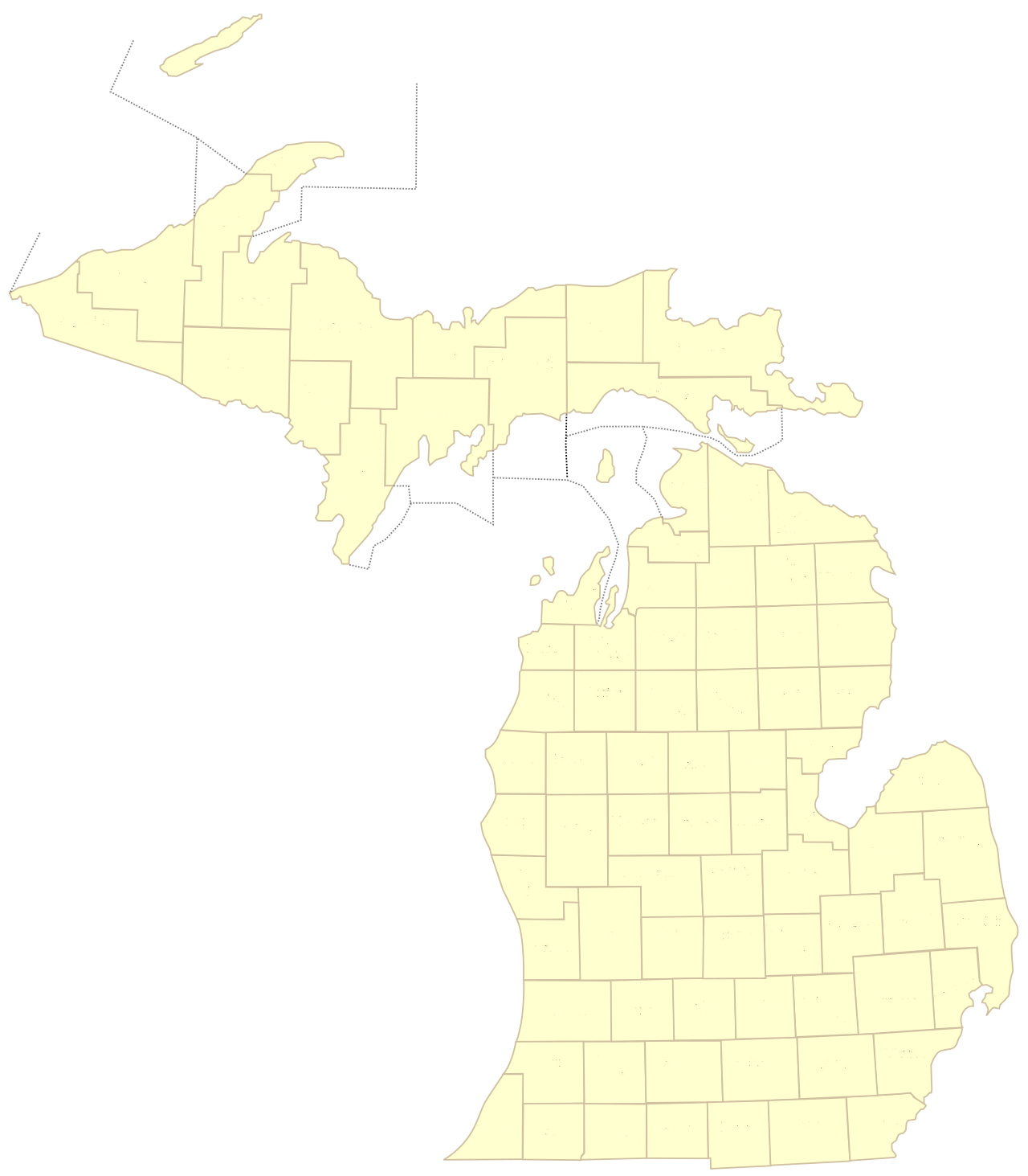
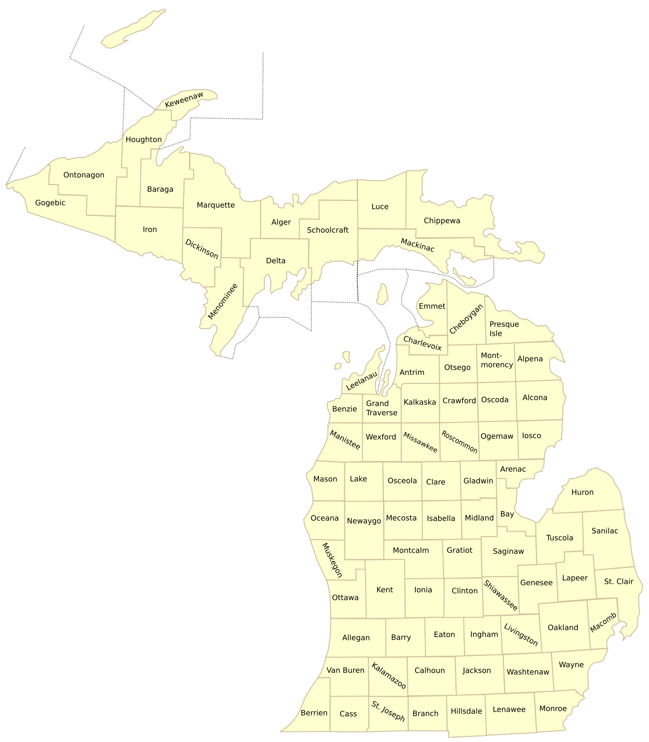
Figure 1: Master cartographic basemap showing Michigan’s 83 county jurisdictions governing state forest and public land boundaries.
Understanding Michigan’s Public Land Architecture & Legal Access Rules
Public land in Michigan is divided into four primary administrative jurisdictions, each operating under distinct statutory regulations governing firearms discharge, motorized vehicle access, camping, and timber harvesting:
The Four Primary Public Land Classifications:
- Michigan State Forests (DNR Wildlife Division – ~3.9 Million Acres): Spanning the Northern Lower Peninsula and Upper Peninsula, state forests are managed for multiple uses including timber management, wildlife habitat restoration, and dispersed recreational hunting. Dispersed rustic camping is permitted on state forest land at no charge provided campsites are located at least one mile from state forest campgrounds and properly registered with a free DNR camp registration card.
- State Game Areas & Wildlife Research Areas (~350,000 Acres): Located primarily in southern Lower Michigan (such as Allegan SGA, Barry SGA, Gratiot-Saginaw SGA, and Dansville SGA), these public parcels were purchased using Pittman-Robertson federal excise tax revenues on hunting equipment. They are intensively managed with agricultural food plots, wetland impoundments, and controlled prairie burns specifically to optimize whitetail deer, wild turkey, ring-necked pheasant, and waterfowl populations.
- U.S. National Forests (U.S. Forest Service – ~2.8 Million Acres): Encompasses the Huron-Manistee National Forests in the Lower Peninsula, and the Hiawatha National Forest and Ottawa National Forest in the Upper Peninsula. Open to public hunting and fishing under Michigan state bag limits and season dates, governed by federal motor vehicle use maps (MVUM).
- Commercial Forest Act (CFA) Private Timberlands (~2.2 Million Acres): Under Michigan’s Commercial Forest Program (Part 511 of PA 451), private commercial timberland owners receive significant property tax reductions in exchange for granting the general public year-round foot access for hunting and fishing without charge. Motorized vehicles, permanent hunting blinds, and camping are strictly prohibited on CFA parcels.
The Michigan Hunting Access Program (HAP):
In southern Michigan counties where over 95 percent of land is privately owned, the DNR administers the Hunting Access Program (HAP). Private farmers and rural landowners receive annual state lease payments to open their private acreage to public hunters. Hunters must check in at designated on-site registration boxes at the property boundary, adhering to strict landowner rules regarding designated parking, crop field buffers, and species authorizations (e.g., archery deer only, youth hunt only, or all-species hunting).
Navigating Public Boundaries: Mi-HUNT & GPS Boundary Applications
Respecting private property lines while hunting public land is both a legal mandate and a foundational principle of ethical outdoor sportsmanship. The Michigan Department of Natural Resources provides Mi-HUNT, an interactive web-based GIS mapping application that displays aerial imagery, public land boundary lines, cover types (e.g., aspen, oak, lowland conifer), and satellite vegetation density. Sportsmen regularly cross-reference Mi-HUNT data with mobile GPS mapping applications (such as onX Hunt and HuntStand) to avoid inadvertent recreational trespassing onto posted private parcels bordering state game tracts.
County Directory: Public Lands, State Game Areas & Game Species by County
The following master directory indexes all 83 Michigan counties with their primary public land reserves, dominant wildlife game species, and relative public land density ratings:
| County | County Seat | Major Public Land Reserves & Game Areas | Key Game Species | Public Land Density |
|---|---|---|---|---|
| Alcona | Harrisville | Huron National Forest, Alcona State Forest | Whitetail Deer, Ruffed Grouse, Black Bear | High (>40%) |
| Alger | Munising | Hiawatha National Forest, Pictured Rocks Lakeshore | Black Bear, Whitetail Deer, Snowshoe Hare | Very High (>65%) |
| Allegan | Allegan | Allegan State Game Area (50,000+ acres) | Whitetail Deer, Wild Turkey, Waterfowl | Moderate (~15%) |
| Alpena | Alpena | Alpena State Forest, Norway Ridge Pathways | Whitetail Deer, Woodcock, Grouse | Moderate (~25%) |
| Antrim | Bellaire | Jordan River Valley State Forest | Ruffed Grouse, Brook Trout, Whitetail Deer | Moderate (~20%) |
| Arenac | Standish | Wigwam Bay State Wildlife Area, Saganing SGA | Waterfowl (Mallards, Pintails), Deer | Low (~8%) |
| Baraga | L’Anse | Ottawa National Forest, Baraga Plains Wildlife Area | Black Bear, Ruffed Grouse, Moose | Very High (>60%) |
| Barry | Hastings | Barry State Game Area (16,000+ acres), Yankee Springs | Wild Turkey, Whitetail Deer, Cottontail | Moderate (~18%) |
| Bay | Bay City | Tobico Marsh / Bay City State Park, Nayanquing Point | Ducks, Geese, Pheasant | Low (~5%) |
| Benzie | Beulah | Sleeping Bear Dunes National Lakeshore, Betsie River | Whitetail Deer, Woodcock, Waterfowl | Moderate (~30%) |
| Berrien | St. Joseph | Warren Dunes State Park, Grand Mere, Galien River | Whitetail Deer, Waterfowl | Low (~4%) |
| Branch | Coldwater | Coldwater Lake State Park, Girard Public Access | Waterfowl, Whitetail Deer, Small Game | Low (~2%) |
| Calhoun | Marshall | Fort Custer State Recreation Area, Duck Lake | Whitetail Deer, Wild Turkey, Small Game | Low (~5%) |
| Cass | Cassopolis | Crane Pond State Game Area (4,000+ acres) | Whitetail Deer, Turkey, Waterfowl | Low (~6%) |
| Charlevoix | Charlevoix | Mackinaw State Forest, Beaver Island Wildlife Area | Whitetail Deer, Grouse, Small Game | High (~35%) |
| Cheboygan | Cheboygan | Pigeon River Country State Forest, Black Lake | Elk, Whitetail Deer, Black Bear, Grouse | Very High (>55%) |
| Chippewa | Sault Ste. Marie | Hiawatha National Forest, Munuscong State Wildlife Area | Waterfowl, Black Bear, Whitetail Deer | High (~45%) |
| Clare | Harrison | Ausable State Forest, Leota ORV & Game Lands | Whitetail Deer, Grouse, Turkey | Moderate (~25%) |
| Clinton | St. Johns | Rose Lake State Wildlife Research Area (4,000+ acres) | Pheasant, Whitetail Deer, Cottontail | Low (~4%) |
| Crawford | Grayling | Au Sable State Forest, Hartwick Pines, Camp Grayling | Whitetail Deer, Black Bear, Kirtland’s Warbler | Very High (>60%) |
| Delta | Escanaba | Hiawatha National Forest, Escanaba River State Forest | Whitetail Deer, Black Bear, Grouse | High (~50%) |
| Dickinson | Iron Mountain | Copper Country State Forest, Gene’s Pond | Whitetail Deer, Ruffed Grouse, Bear | High (~45%) |
| Eaton | Charlotte | Grand Ledge / Fitzgerald Park, Charlotte Wildlife Tracts | Whitetail Deer, Wild Turkey, Pheasant | Low (~2%) |
| Emmet | Petoskey | Wilderness State Park, Mackinaw State Forest | Whitetail Deer, Snowshoe Hare, Waterfowl | Moderate (~30%) |
| Genesee | Flint | Holloway Reservoir, Murphy Lake SGA (nearby) | Whitetail Deer, Waterfowl, Cottontail | Low (~3%) |
| Gladwin | Gladwin | Gladwin State Forest Reserve, Tittabawassee River | Whitetail Deer, Ruffed Grouse, Turkey | Moderate (~22%) |
| Gogebic | Bessemer | Ottawa National Forest, Porcupine Mountains | Black Bear, Whitetail Deer, Grouse | Very High (>65%) |
| Grand Traverse | Traverse City | Pere Marquette State Forest, Boardman River Basin | Whitetail Deer, Ruffed Grouse, Turkey | Moderate (~25%) |
| Gratiot | Ithaca | Gratiot-Saginaw State Game Area (16,000+ acres) | Whitetail Deer, Pheasant, Wild Turkey | Low (~7%) |
| Hillsdale | Hillsdale | Lost Nation State Game Area (2,400+ acres) | Whitetail Deer, Wild Turkey, Small Game | Low (~4%) |
| Houghton | Houghton | Ottawa National Forest, Copper Country State Forest | Black Bear, Ruffed Grouse, Deer | High (~40%) |
| Huron | Bad Axe | Rush Lake State Game Area, Verona State Game Area | Pheasant, Waterfowl, Whitetail Deer | Low (~5%) |
| Ingham | Mason | Dansville State Game Area (4,000+ acres) | Whitetail Deer, Wild Turkey, Cottontail | Low (~3%) |
| Ionia | Ionia | Flat River State Game Area, Ionia State Rec Area | Whitetail Deer, Wild Turkey, Waterfowl | Low (~8%) |
| Iosco | Tawas City | Huron National Forest, Tuttle Marsh Wildlife Area | Whitetail Deer, Black Bear, Waterfowl | High (~48%) |
| Iron | Crystal Falls | Ottawa National Forest, Copper Country State Forest | Black Bear, Whitetail Deer, Grouse | Very High (>60%) |
| Isabella | Mt. Pleasant | Chippewa River State Game Lands, Mount Pleasant SGA | Whitetail Deer, Turkey, Small Game | Low (~5%) |
| Jackson | Jackson | Waterloo State Recreation Area (20,000+ acres) | Whitetail Deer, Wild Turkey, Waterfowl | Moderate (~12%) |
| Kalamazoo | Kalamazoo | Fort Custer State Recreation Area, Gourdneck SGA | Whitetail Deer, Turkey, Waterfowl | Low (~4%) |
| Kalkaska | Kalkaska | Pere Marquette State Forest, Manistee River Tracts | Whitetail Deer, Ruffed Grouse, Bear | High (~45%) |
| Kent | Grand Rapids | Rogue River State Game Area, Flat River SGA | Whitetail Deer, Turkey, Waterfowl | Low (~5%) |
| Keweenaw | Eagle River | Fort Wilkins, Keweenaw Tip CFA Lands, Isle Royale | Black Bear, Snowshoe Hare, Grouse | Very High (>70%) |
| Lake | Baldwin | Huron-Manistee National Forests, Pere Marquette River | Whitetail Deer, Grouse, Wild Turkey | High (~48%) |
| Lapeer | Lapeer | Lapeer State Game Area (9,000+ acres) | Whitetail Deer, Wild Turkey, Small Game | Low (~6%) |
| Leelanau | Suttons Bay | Sleeping Bear Dunes National Lakeshore (NPS) | Whitetail Deer, Woodcock, Waterfowl | Moderate (~20%) |
| Lenawee | Adrian | Onsted State Wildlife Area, Lake Hudson State Rec Area | Whitetail Deer, Wild Turkey, Waterfowl | Low (~3%) |
| Livingston | Howell | Pinckney State Recreation Area, Island Lake, Gregory SGA | Whitetail Deer, Turkey, Small Game | Low (~8%) |
| Luce | Newberry | Lake Superior State Forest, Tahquamenon River Basin | Black Bear, Moose, Whitetail Deer, Grouse | Very High (>55%) |
| Mackinac | St. Ignace | Hiawatha National Forest, Mackinac Island State Park | Whitetail Deer, Black Bear, Waterfowl | High (~45%) |
| Macomb | Mount Clemens | Wetzel State Recreation Area, St. Clair Flats (nearby) | Whitetail Deer, Small Game, Waterfowl | Low (~2%) |
| Manistee | Manistee | Huron-Manistee National Forests, Manistee River Trail | Whitetail Deer, Ruffed Grouse, Turkey | Moderate (~35%) |
| Marquette | Marquette | Copper Country State Forest, Escanaba River Forest | Black Bear, Whitetail Deer, Ruffed Grouse | High (~45%) |
| Mason | Ludington | Huron-Manistee National Forests, Ludington State Park | Whitetail Deer, Ruffed Grouse, Turkey | Moderate (~28%) |
| Mecosta | Big Rapids | Haymarsh Lake State Game Area (6,700+ acres) | Whitetail Deer, Waterfowl, Turkey | Moderate (~15%) |
| Menominee | Menominee | Escanaba River State Forest, Menominee River Basin | Whitetail Deer, Black Bear, Grouse | Moderate (~28%) |
| Midland | Midland | Au Sable State Forest (Kawkawlin River Tracts) | Whitetail Deer, Wild Turkey, Grouse | Moderate (~15%) |
| Missaukee | Lake City | Pere Marquette State Forest, Dead Stream Swamp | Whitetail Deer, Bear, Grouse, Elk (stray) | High (~40%) |
| Monroe | Monroe | Pointe Mouillee State Game Area, Petersburg SGA | Waterfowl (Mallards, Canvasbacks), Deer | Low (~5%) |
| Montcalm | Stanton | Langston State Game Area, Flat River SGA | Whitetail Deer, Wild Turkey, Waterfowl | Low (~8%) |
| Montmorency | Atlanta | Pigeon River Country State Forest, Clear Lake | Elk, Whitetail Deer, Black Bear, Grouse | High (~40%) |
| Muskegon | Muskegon | Muskegon State Game Area (10,000+ acres delta) | Waterfowl, Whitetail Deer, Wild Turkey | Moderate (~15%) |
| Newaygo | White Cloud | Huron-Manistee National Forests, Hardy Dam Tracts | Whitetail Deer, Wild Turkey, Grouse | Moderate (~35%) |
| Oakland | Pontiac | Holly State Recreation Area, Highland SRA, Ortonville | Whitetail Deer, Waterfowl, Small Game | Low (~6%) |
| Oceana | Hart | Manistee National Forest, Pentwater River SGA | Whitetail Deer, Wild Turkey, Woodcock | Moderate (~25%) |
| Ogemaw | West Branch | Ogemaw Hills Pathway, Rifle River State Rec Area | Whitetail Deer, Black Bear, Turkey | Moderate (~30%) |
| Ontonagon | Ontonagon | Porcupine Mountains Wilderness (60,000 acres), Ottawa NF | Black Bear, Whitetail Deer, Snowshoe Hare | Very High (>70%) |
| Osceola | Reed City | Pere Marquette State Forest, Sunrise Lake Public Lands | Whitetail Deer, Ruffed Grouse, Turkey | Moderate (~20%) |
| Oscoda | Mio | Huron National Forest, Au Sable River Holy Waters | Whitetail Deer, Black Bear, Ruffed Grouse | High (~45%) |
| Otsego | Gaylord | Pigeon River Country State Forest (Elk Herd Core) | Rocky Mountain Elk, Deer, Bear, Grouse | Moderate (~35%) |
| Ottawa | Grand Haven | Grand River Open Space, Port Sheldon State Wildlife Area | Waterfowl, Whitetail Deer | Low (~4%) |
| Presque Isle | Rogers City | Mackinaw State Forest, Ocqueoc Falls Public Forest | Whitetail Deer, Black Bear, Grouse | Moderate (~32%) |
| Roscommon | Roscommon | Houghton Lake State Forest, Dead Stream Swamp | Whitetail Deer, Black Bear, Waterfowl | High (~50%) |
| Saginaw | Saginaw | Shiawassee National Wildlife Refuge, Crow Island SGA | Waterfowl (Geese, Ducks), Deer | Low (~5%) |
| St. Clair | Port Huron | Port Huron State Game Area, St. Clair Flats Wildlife Area | Waterfowl, Whitetail Deer, Small Game | Low (~6%) |
| St. Joseph | Centreville | Fabius State Game Area, Three Rivers SGA | Whitetail Deer, Wild Turkey, Small Game | Low (~4%) |
| Sanilac | Sandusky | Minden City State Game Area, Sanilac State Game Area | Whitetail Deer, Pheasant, Turkey | Low (~5%) |
| Schoolcraft | Manistique | Seney National Wildlife Refuge (95,000 acres), Hiawatha NF | Black Bear, Moose, Waterfowl, Deer | Very High (>65%) |
| Shiawassee | Corunna | Rose Lake State Wildlife Area (nearby), Shiawassee River | Whitetail Deer, Wild Turkey, Small Game | Low (~2%) |
| Tuscola | Caro | Fish Point State Wildlife Area, Deford State Game Area | Waterfowl (Mallards, Teal), Pheasant, Deer | Low (~8%) |
| Van Buren | Paw Paw | Keeler State Game Area, Van Buren State Park | Whitetail Deer, Turkey, Waterfowl | Low (~4%) |
| Washtenaw | Ann Arbor | Waterloo State Recreation Area, Sharonville SGA | Whitetail Deer, Wild Turkey, Small Game | Low (~7%) |
| Wayne | Detroit | Pointe Mouillee SGA (Detroit River mouth), Belle Isle | Waterfowl (Diver Ducks, Mallards) | Low (~1%) |
| Wexford | Cadillac | Manistee National Forest, Pere Marquette State Forest | Whitetail Deer, Ruffed Grouse, Turkey | Moderate (~35%) |
Regional Hunting Highlights: From Upper Peninsula Wilderness to Southern Farmland
Michigan’s hunting landscape transitions dramatically across its two peninsulas, offering distinct sporting pursuits governed by regional forest cover types and agricultural soil fertility:
Three Distinct Regional Hunting Ecosystems:
- The Upper Peninsula Wilderness (Zone 1): Encompassing 15 counties where public land exceeds 50 to 70 percent of total land area. Renowned for remote, backcountry big-woods hunting for black bear, ruffed grouse in regenerating aspen cuts, and hardy, mature whitetail bucks navigating deep winter snow belts. Counties like Gogebic, Ontonagon, and Iron offer true solitude where hunters can walk miles without encountering paved roads.
- Northern Lower Peninsula Forest & Elk Country (Zone 2): Home to the Pigeon River Country State Forest across Otsego, Montmorency, and Cheboygan counties—the core territory of Michigan’s wild Rocky Mountain elk herd (managed via highly coveted annual lottery hunt licenses). Counties like Crawford, Roscommon, and Kalkaska offer extensive oak-pine ridges, cedar swamps, and premier woodcock flyways along the Au Sable and Manistee river headwaters.
- Southern Lower Peninsula Agricultural Belt (Zone 3): Featuring rich agricultural soils, corn, and soybean crops that produce Michigan’s highest whitetail deer densities and trophy antler growth. While public land is limited, major state game areas like Allegan SGA (50,000 acres), Barry SGA (16,000 acres), and Lapeer SGA (9,000 acres) provide premier public archery and firearm deer hunting, spring wild turkey hunting, and managed waterfowl marsh blinds within easy driving distance of Detroit, Grand Rapids, and Lansing.
Waterfowl Staging Sanctuaries on Saginaw Bay & Lake Erie:
Michigan is positioned along the Mississippi and Atlantic waterfowl flyways. World-class managed waterfowl hunting areas—such as Fish Point Wildlife Area in Tuscola County, Nayanquing Point in Bay County, Shiawassee River State Game Area in Saginaw County, and Pointe Mouillee State Game Area in Monroe County—utilize daily morning hunting lotteries to allocate regulated shooting zones across managed diked corn marshes, drawing waterfowl hunters targeting mallards, black ducks, pintails, and diving canvasbacks.
Frequently Asked Questions: Michigan Public Land & Hunting Access
Which Michigan county has the most public land?
By total acreage, Marquette County in the central Upper Peninsula possesses the largest volume of public land in Michigan, featuring over 500,000 acres of state forest, CFA private timberlands, and federal preserves. By percentage of land area, western Upper Peninsula counties like Ontonagon and Keweenaw lead the state, with over 70 percent of their land open to public recreational access.
Can you camp anywhere on Michigan state forest land?
Yes, dispersed rustic camping is allowed on unposted state forest land across Michigan at no cost. Campers must locate their campsite at least one mile from any designated state forest campground, ensure it is not located within a state game area or state park, properly dispose of waste, and complete and display a free DNR Camp Registration Card at the campsite.
What is the Commercial Forest Act (CFA) and how do you access CFA land?
The Commercial Forest Act (CFA) is a Michigan tax incentive program covering approximately 2.2 million acres of private commercial timberland. Participating landowners must grant the public free foot access for hunting and fishing. Motorized vehicles, target shooting, permanent tree stands, and camping are strictly prohibited on CFA parcels.
Are tree stands and ground blinds allowed on Michigan public hunting land?
Yes, but with strict seasonal regulations. On public land, hunters may only place portable tree stands and ground blinds between September 1 and the following March 1. The stand or blind must be clearly labeled with the hunter’s name and address, or Michigan DNR Sportcard number. Screw-in tree steps and any fasteners that damage live trees are illegal.
What is the Hunting Access Program (HAP)?
The Hunting Access Program (HAP) is a DNR initiative that leases private agricultural and forest land in southern Lower Michigan and parts of the northern Lower Peninsula to provide public hunting access. Hunters must register in person at the property’s on-site mailbox kiosk before entering and follow specific landowner guidelines.
Explore Related Michigan Cartographic & County Resources
- Upper Peninsula Michigan County Map (15 Northern Counties)
- Northern Michigan County Map (21 Up North Vacation Counties)
- Michigan Highway and County Transportation Map
- Complete Alphabetical List of All 83 Michigan Counties
- Michigan Counties Ranked by Total Land Area
- Printable Michigan County Map (PDF Downloads)