
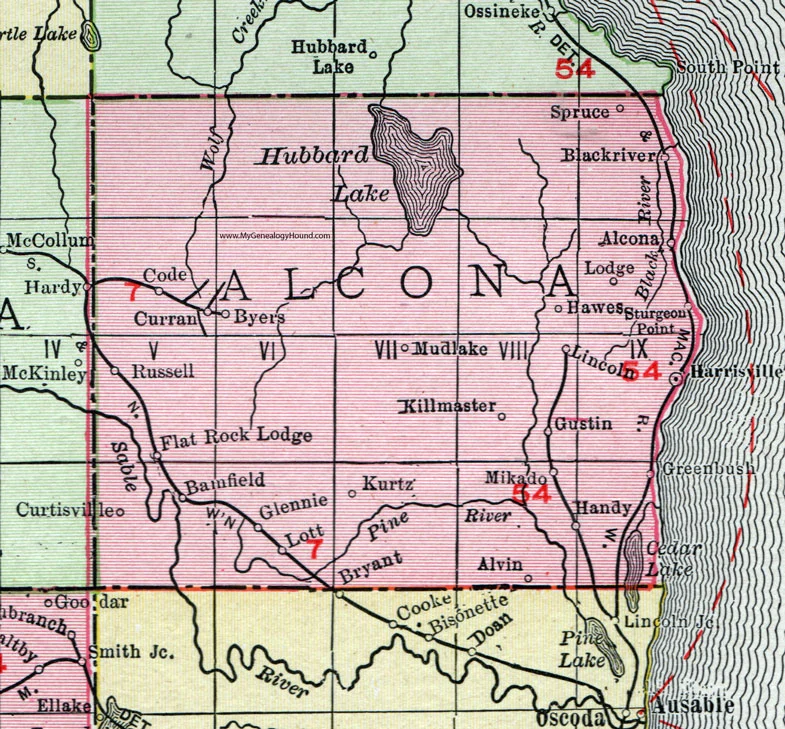
Alcona County, located along the northeastern shoreline of Michigan’s Lower Peninsula, is a hidden gem for travelers, nature enthusiasts, and Michigan map lovers. Whether you’re planning a road trip, exploring property boundaries, or studying Michigan geography, having an accurate Alcona County map helps you navigate this scenic region with confidence.
If you’re exploring more counties across the state, check out our complete Michigan County Map for an interactive overview of all 83 counties.
Where is Alcona County in Michigan?
Alcona County sits on the shores of Lake Huron, bordered by Oscoda County, Iosco County, Montmorency County, and Alpena County. The county’s central city is Harrisville, known for its lighthouse, beaches, and quiet coastal charm.
| Feature | Details |
|---|---|
| County Seat | Harrisville |
| Region | Northeastern Lower Peninsula |
| Founded | 1840 |
| Area | 1,791 sq mi (approx. 70% water) |
| Major Highways | US-23, M-72, F-41 |
| Nearby Counties | Alpena, Oscoda, Montmorency, Iosco |
| Population (2020) | ~10,000 |
| ZIP Codes | 48705–48790 range |
Map Overview & Geographic Highlights
An interactive Alcona County map shows not just the city limits but also natural features like forests, lakes, and state parks. The Huron-Manistee National Forests stretch through the western edge, while Harrisville State Park and Negwegon State Park line the coast — offering rich outdoor experiences.
Key townships you’ll find on the Alcona County township map include:
- Harrisville Township – coastal, scenic, and residential.
- Caledonia Township – inland forests and farms.
- Greenbush Township – lakeside trails and campgrounds.
- Gustin Township – historic rail lines and heritage sites.
Why Use the Alcona County Map?
A detailed Alcona County Michigan map helps with:
- Travel planning – locating highways, gas stations, and campgrounds.
- Real estate – understanding property zones and county boundaries.
- Education – studying Michigan’s local geography and administrative divisions.
- Outdoor recreation – identifying hiking, fishing, and lake areas.