
Michigan Highway and County Map: Interstate, US Routes & State Road Corridors
A comprehensive cartographic guide to Michigan’s statewide transportation network. Learn how Interstate freeways (I-75, I-94, I-96, I-69), US highways (US-131, US-23, US-31, US-2, US-41), and state trunklines interconnect all 83 Michigan counties, complete with printable PDF maps.
Download Official Michigan Highway & Arterial Network Maps
Precision cartographic vector PDF showing all Interstate, US, and state highway routes overlaid with county boundaries.
High-Resolution Michigan Highway & Road Network Map
The map below illustrates Michigan’s comprehensive highway framework. Interstates are denoted in blue shields, US routes in white shields, and state trunklines in white diamond markers. All 83 county boundary jurisdictions are outlined to demonstrate how logistics corridors traverse the state.
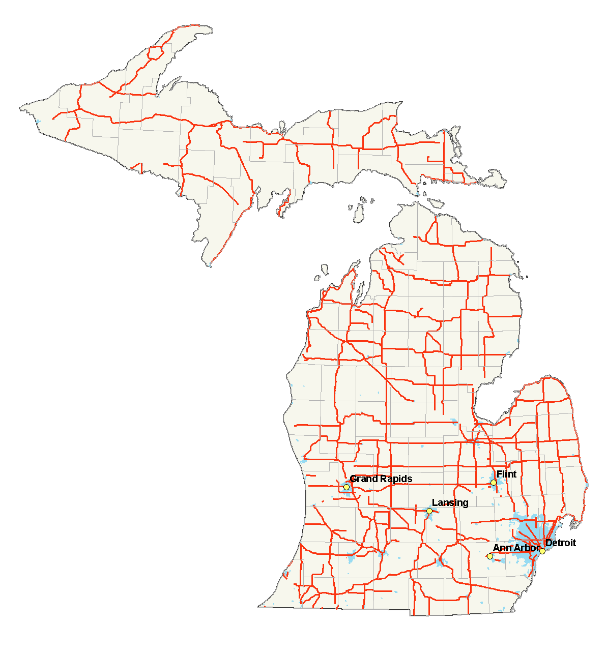
Figure 1: Official Michigan State Highway Network and County Arterials cartographic map.
Major Highway Corridors Across Michigan Counties
Detailed breakdown of primary Interstate, US, and state highway routes, including counties traversed and major economic hubs connected.
| Highway Corridor | Classification | Length | Counties Traversed | Major Hubs | Role & Connectivity |
|---|---|---|---|---|---|
| Interstate 75 (I-75) | Interstate | 395 miles | Monroe, Wayne, Oakland, Genesee, Saginaw, Bay, Arenac, Ogemaw, Roscommon, Crawford, Otsego, Cheboygan, Mackinac, Chippewa | Detroit, Flint, Saginaw, Bay City, Grayling, St. Ignace, Sault Ste. Marie | Primary North-South artery of Michigan, crossing the Mackinac Bridge to Canada |
| Interstate 94 (I-94) | Interstate | 275 miles | Berrien, Van Buren, Kalamazoo, Calhoun, Jackson, Washtenaw, Wayne, Macomb, St. Clair | New Buffalo, Kalamazoo, Battle Creek, Jackson, Ann Arbor, Detroit, Port Huron | Main Midwest commerce corridor connecting Chicago, Detroit, and Ontario via Blue Water Bridge |
| Interstate 96 (I-96) | Interstate | 192 miles | Muskegon, Ottawa, Kent, Ionia, Clinton, Eaton, Ingham, Livingston, Oakland, Wayne | Muskegon, Grand Rapids, Lansing, Howell, Detroit | Critical central east-west link connecting Lake Michigan coast to Detroit through the state capital |
| Interstate 69 (I-69) | Interstate | 202 miles | Branch, Calhoun, Eaton, Clinton, Shiawassee, Genesee, Lapeer, St. Clair | Coldwater, Marshall, Charlotte, Lansing, Flint, Lapeer, Port Huron | Major NAFTA international freight corridor linking Indiana to Canada |
| Interstate 196 (I-196) | Interstate | 80 miles | Berrien, Van Buren, Allegan, Ottawa, Kent | Benton Harbor, South Haven, Holland, Grand Rapids | Southwest Michigan lakeshore freeway connecting I-94 to Grand Rapids |
| US Highway 131 (US-131) | US Highway | 269 miles | St. Joseph, Kalamazoo, Allegan, Kent, Montcalm, Mecosta, Osceola, Wexford, Grand Traverse, Kalkaska, Antrim, Charlevoix, Emmet | Three Rivers, Kalamazoo, Grand Rapids, Big Rapids, Cadillac, Petoskey | Primary western Lower Peninsula arterial spine connecting southern border to Petoskey |
| US Highway 23 (US-23) | US Highway | 362 miles | Monroe, Washtenaw, Livingston, Genesee, Saginaw, Bay, Arenac, Iosco, Alcona, Alpena, Presque Isle, Cheboygan | Ann Arbor, Flint, Bay City, Tawas City, Alpena, Mackinaw City | Eastern Lower Peninsula and Lake Huron coastline scenic and commercial route |
| US Highway 31 (US-31) | US Highway | 356 miles | Berrien, Van Buren, Allegan, Ottawa, Muskegon, Oceana, Mason, Manistee, Benzie, Grand Traverse, Antrim, Charlevoix, Emmet | Niles, Holland, Muskegon, Ludington, Traverse City, Petoskey, Mackinaw City | Lake Michigan scenic coastal highway passing Sleeping Bear Dunes |
| US Highway 127 (US-127) | US Highway | 214 miles | Hillsdale, Lenawee, Jackson, Ingham, Clinton, Gratiot, Isabella, Clare | Hudson, Jackson, Lansing, St. Johns, Alma, Mt. Pleasant, Clare | Central Michigan spine freeway connecting southern border to US-10 / I-75 junction |
| US Highway 2 (US-2) | US Highway | 305 miles (MI portion) | Mackinac, Schoolcraft, Delta, Menominee, Dickinson, Iron, Gogebic | St. Ignace, Manistique, Escanaba, Iron Mountain, Crystal Falls, Watersmeet, Ironwood | Primary southern Upper Peninsula east-west lifeway from Mackinac Bridge to Wisconsin |
| US Highway 41 (US-41) | US Highway | 279 miles (MI portion) | Menominee, Delta, Marquette, Baraga, Houghton, Keweenaw | Menominee, Escanaba, Marquette, L’Anse, Houghton, Calumet, Copper Harbor | Backbone highway of the central/northern U.P. and Copper Country |
| M-28 | State Highway | 290 miles | Gogebic, Ontonagon, Houghton, Iron, Baraga, Marquette, Alger, Schoolcraft, Luce, Chippewa | Wakefield, Ishpeming, Marquette, Munising, Seney, Newberry, Sault Ste. Marie | Longest continuous state trunkline in Michigan, crossing the U.P. wilderness and Seney Stretch |
Strategic Highway Corridors: Regional Analysis
1. The I-75 North-South Lifeline
Interstate 75 is the commercial backbone of Michigan. Entering from Ohio into Monroe County, it bisects Wayne, Oakland, and Genesee before continuing north through Saginaw, crossing the Mackinac Bridge, and terminating at the international border in Sault Ste. Marie.
2. The I-94 & I-96 East-West Freight Axes
Interstate 94 links Chicago to Detroit, running across Berrien, Kalamazoo, Calhoun, Jackson, and Washtenaw. Further north, I-96 links Grand Rapids in Kent County to Lansing in Ingham County and Detroit.
3. US-131 & US-31 Western Michigan Spines
US-131 serves as the primary multi-lane freeway linking Kalamazoo and Grand Rapids to northern tourist regions including Cadillac and Petoskey. Along the shoreline, US-31 traverses Ottawa, Muskegon, and Grand Traverse counties.
4. Upper Peninsula Cross-Country Lifelines
In the Upper Peninsula, US-2 hugs the southern Lake Michigan shoreline from St. Ignace to Escanaba and Iron Mountain, while US-41 climbs through Marquette County all the way to Keweenaw County. M-28 connects the northern wilderness from Wakefield to Sault Ste. Marie.
Explore Related Michigan Cartographic Resources
Browse our full suite of interactive directories, demographic rankings, and county maps:
International Trade Gateways & Heavy Freight Logistics
Michigan occupies a pivotal position in North American multimodal logistics, functioning as the premier continental land port between the manufacturing supply chains of the United States and Canada. Supported by an extensive network of Interstate, US, and State Trunkline highways maintained by the Michigan Department of Transportation (MDOT), the state facilitates hundreds of billions of dollars in cross-border trade annually:
Critical International Border Gateways:
- Detroit-Windsor International Gateway (Wayne County): Linked via the Ambassador Bridge, the Detroit-Windsor Tunnel, and the new multi-billion dollar Gordie Howe International Bridge. This corridor handles more than 25% of all bilateral automotive parts and finished commercial freight between the United States and Canada, connecting directly to I-75 and I-94.
- Blue Water Bridge (St. Clair County): Connecting Port Huron to Point Edward and Sarnia, Ontario, across the head of the St. Clair River. As the northern conduit of the I-69 / I-94 trade corridor, it serves as the primary route for long-haul freight trucks bypassing Detroit’s urban congestion.
- Sault Ste. Marie International Bridge (Chippewa County): Anchoring the northern terminal of I-75, this 2.8-mile bridge connects the Upper Peninsula to Sault Ste. Marie, Ontario, and Trans-Canada Highway 17, providing vital timber, steel, and mineral freight passage above the St. Marys River and historic Soo Locks.
Scenic Heritage Byways & Historic Great Lakes Touring Routes
Beyond commercial freight corridors, Michigan features some of the nation’s most breathtaking designated scenic byways, engineered to showcase the dramatic topography, coastal dunes, and virgin forests of both peninsulas:
- M-22 Scenic Highway (Manistee, Benzie & Leelanau): Tracing 116 miles of pristine Lake Michigan coastline, M-22 loops around the Leelanau Peninsula through Sleeping Bear Dunes National Lakeshore, historic fishing villages, cherry orchards, and world-class cool-climate vineyards.
- M-119 Tunnel of Trees (Emmet County): Beginning north of Harbor Springs and winding along the high bluffs overlooking Lake Michigan to Cross Village, this 20-mile narrow scenic highway traverses dense deciduous canopy, hugging sharp shoreline curves without a painted center line.
- US-23 Huron Shores Heritage Route (Arenac to Cheboygan): Known as Michigan’s Sunrise Side highway, US-23 hugs the dramatic rocky shores and sandy beaches of Lake Huron, connecting coastal lighthouses, maritime shipwreck preserves, and the Au Sable River delta.
- Brockway Mountain Drive (Keweenaw County): The highest paved highway between the Allegheny and Rocky Mountains, climbing to a breathtaking 1,328-foot summit overlooking Lake Superior, copper cliffs, and vast migrating raptor flyways near Copper Harbor.
- US-2 Upper Peninsula Coastal Route: Stretching from the Mackinac Bridge westward through St. Ignace, Epoufette, Manistique, and Escanaba, US-2 treats motorists to panoramic expanses of Lake Michigan’s northern shoreline and pristine northern pine woodlands.
Winter Road Maintenance, Snow Belt Dynamics & Traveler Safety
Traversing Michigan’s highway network during winter months requires an understanding of localized lake-effect meteorological dynamics. Prevailing westerly winds blowing across unfrozen waters of Lake Michigan and Lake Superior deposit heavy snow squalls along primary corridors, including US-131 through Grand Rapids, Cadillac, and Petoskey; I-94 between New Buffalo and Kalamazoo; and US-41 across the Marquette Iron Range.
The Michigan Department of Transportation deploys an extensive fleet of advanced winter maintenance plows equipped with automated liquid deicer application, tow-plow attachments, and live GPS location beacons visible on the MDOT Mi Drive web portal. Motorists navigating county expressways are advised to monitor dynamic overhead variable message signs, check real-time traffic camera feeds, and maintain emergency winter supply kits during lake-effect winter storm warnings.
Michigan’s Engineering Marvels: The Great Straits & River Bridges
Because Michigan is divided into two distinct peninsulas separated by the five-mile-wide Straits of Mackinac and flanked by swift international border waterways, the state’s transportation network is defined by world-famous long-span bridges. These engineering landmarks unite Michigan’s counties into an integrated economic and cultural commonwealth:
Michigan’s Premier Bridge Corridors:
- The Mackinac Bridge ("Mighty Mac" – Emmet & Mackinac Counties): Spanning five miles across the Straits of Mackinac to unite Mackinaw City in the Lower Peninsula with St. Ignace in the Upper Peninsula, the Mackinac Bridge opened on November 1, 1957. Engineered by master bridge designer David B. Steinman, its 3,800-foot central suspension span was specifically calculated to withstand extreme Great Lakes gales exceeding 150 mph. Every Labor Day, tens of thousands of pedestrians participate in the annual Mackinac Bridge Walk, led by Michigan’s governor.
- Blue Water Bridges (St. Clair County): A twin-span international bridge system carrying I-69 and I-94 over the St. Clair River between Port Huron and Point Edward, Ontario. The original continuous-truss span opened in 1938, supplemented by a modern continuous-tied arch span in 1997 to handle accelerating commercial freight volumes.
- The Zilwaukee Bridge (Saginaw County): A monumental eight-lane segmental concrete box girder bridge carrying I-75 and US-23 over the Saginaw River in Zilwaukee Township. Rising 125 feet above the water, this high-level structure eliminated notorious drawbridge traffic gridlocks along Michigan’s primary northbound recreational route.
- Gordie Howe International Bridge (Wayne County): A state-of-the-art cable-stayed crossing between Detroit and Windsor, Ontario. Featuring a 2,799-foot main span with no piers in the water, it ranks among the largest cable-stayed bridges in North America, equipped with automated customs processing plazas, dedicated multi-use pedestrian greenways, and direct highway-to-highway connections to I-75.
MDOT Intelligent Transportation Systems (ITS) & Traffic Centers:
To safeguard millions of annual commuters and interstate truck drivers, MDOT operates regional Statewide Transportation Operations Centers (STOC) in Lansing and Detroit. Utilizing hundreds of high-definition closed-circuit traffic cameras, microwave vehicle sensors, automated wrong-way driver detection alerts, and dynamic electronic variable message signs, traffic engineers monitor incident response, clear hazardous crash bottlenecks, and coordinate real-time detour routing around highway construction zones.
Electric Vehicle Infrastructure & Michigan’s Future Mobility Corridors
As the birthplace of the American automotive industry, Michigan is actively transforming its highway corridors into next-generation smart transportation networks. Through the National Electric Vehicle Infrastructure (NEVI) formula program and MDOT’s Lake Michigan EV Circuit initiative, high-speed DC fast-charging stations (150kW to 350kW) are being systematically deployed at maximum 50-mile intervals along all designated alternative fuel corridors:
Key Michigan Connected & EV Highway Corridors:
- Lake Michigan EV Circuit: Tracing US-31 and coastal trunklines from New Buffalo north through Holland, Muskegon, Ludington, Traverse City, and Mackinaw City, providing seamless fast-charging access for coastal eco-tourists visiting state parks and coastal resort destinations.
- I-94 CAV Corridor: A pioneering connected and automated vehicle (CAV) test corridor spanning Wayne, Washtenaw, and Jackson counties between Detroit and Ann Arbor, engineered with dedicated smart sensors, vehicle-to-infrastructure (V2I) communication, and dynamic lane controls to facilitate autonomous freight testing.
- Upper Peninsula Cross-Peninsula EV Network: Establishing strategic charging hubs along US-2 and US-41 in Iron Mountain, Escanaba, Marquette, Manistique, and Sault Ste. Marie, ensuring reliable winter electric vehicle transit across vast northern wilderness stretches.
Rest Areas & Traveler Welcome Centers:
MDOT operates 77 roadside rest areas and 14 comprehensive Welcome Centers strategically located at interstate border gateways (such as Coldwater on I-69, New Buffalo on I-94, Monroe on I-75, and Sault Ste. Marie on I-75). These facilities provide free wireless internet, 24-hour commercial truck parking, ADA-compliant restrooms, real-time travel weather displays, and complimentary printed Michigan transportation maps for traveling motorists.
How does the Michigan Department of Transportation classify state trunklines versus local county roads?
Under Michigan law (Public Act 51 of 1951), public roadways are strictly divided into three distinct operational jurisdictions. The Michigan Department of Transportation (MDOT) directly finances, designs, and maintains all Interstate highways (e.g., I-75, I-94, I-96), US routes (e.g., US-131, US-23, US-2, US-41), and State Trunkline highways (designated with the ‘M-‘ prefix like M-28 or M-53). Conversely, all public roads outside incorporated city boundaries that lack an Interstate, US, or M-designation are under the direct jurisdiction of autonomous County Road Commissions, which oversee local primary and secondary rural roads.
Frequently Asked Questions: Michigan Highway & County Map
What is the longest Interstate highway in Michigan?
Interstate 75 (I-75) is Michigan’s longest Interstate highway, covering approximately 395 miles from Monroe County at the Ohio state line in the south, north across the Mackinac Bridge, terminating at Sault Ste. Marie at the Canadian border in Chippewa County.
Which Interstate connects Detroit to Grand Rapids?
Interstate 96 (I-96) directly connects Detroit and its western suburbs to Lansing (state capital in Ingham County) and Grand Rapids (Kent County), before continuing west to Muskegon along Lake Michigan.
How does highway traffic cross between Michigan’s Lower and Upper Peninsulas?
All highway vehicular traffic crosses between the peninsulas via the Mackinac Bridge, a 5-mile suspension bridge carrying Interstate 75 from Mackinaw City (Lower Peninsula) to St. Ignace (Upper Peninsula).
Where can I download the official Michigan highway and county map PDF?
You can download the high-resolution vector PDF of the Michigan State Highway Network and County Arterials directly from MichiganCountyMap.com using the download buttons provided on this page.