Located in the heart of Southeastern Michigan, Washtenaw County is a vibrant convergence of world-class academic institutions, cutting-edge technology hubs, rich agricultural heritage, and historic Huron River communities. Navigating from the bustling cultural districts of Ann Arbor to the historic depots of Ypsilanti requires a clear, reliable geographic guide. This comprehensive Washtenaw County Map is your essential resource for understanding municipal boundaries, townships, major highway corridors, school districts, and public recreational lands. Whether you are a student, relocating homeowner, researcher, or weekend traveler, explore Washtenaw County with our interactive guides and free downloadable maps.
Interactive Washtenaw County Map Michigan
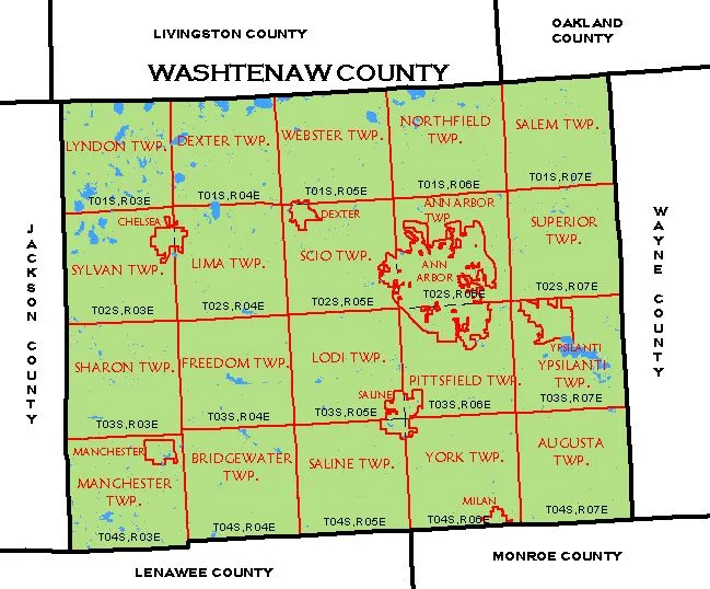
When studying the map of Washtenaw County, several vital geographic features stand out:
- Principal Cities & Villages: Ann Arbor (County Seat), Ypsilanti, Saline, Chelsea, Dexter, and Milan.
- Core Arterial Highways: Interstate 94 (I-94) connecting Detroit to Chicago, US Highway 23 (US-23) connecting Flint and Toledo, and M-14 freeway bypass.
- Academic Campuses: The University of Michigan (Central, North, Medical, and Athletic campuses) and Eastern Michigan University.
- Waterways & Natural Assets: The scenic Huron River Water Trail, Hudson Mills Metropark, Delhi Metropark, and Dexter-Huron Metropark.
Looking for broader regional context? Explore our master Interactive Michigan County Map to see how Washtenaw connects with neighboring Wayne, Oakland, and Livingston counties.
Washtenaw County Facts, Geography & Demographics
Organized in 1826 and named after the Ojibwe word “Wash-ten-ong” (meaning “far off waters” or “Grand River”), Washtenaw County is Michigan’s sixth most populous county, renowned for having the highest rate of educational attainment in the state.
| Geographic Metric | Data / Details |
|---|---|
| County Seat | Ann Arbor (Population: ~123,800) |
| Second Largest City | Ypsilanti (Population: ~19,400) |
| Region | Southeastern Michigan / Ann Arbor Metro |
| Established | September 10, 1822 (Organized 1826) |
| Total Area | 722 sq miles (1,870 km²) |
| Land Area | 706 sq miles (97.7% of total area) |
| Water Area | 16 sq miles (2.3% of total area) |
| Population (Census Est.) | ~372,258 residents |
| Population Density | 527.3 people per sq mile |
| FIPS Code | 26-161 |
| Major Freeways | I-94, US-23, M-14, M-52, M-17 |
| Bordering Counties | Wayne (East), Oakland (Northeast), Livingston (North), Ingham (Northwest), Jackson (West), Lenawee (South), Monroe (Southeast) |
Washtenaw County Township Map & Municipal Breakdown
Washtenaw County is divided into 20 civil townships surrounding its incorporated cities. Understanding the township structure is crucial for property zoning, school district boundaries, and municipal services:
Urban & Suburban Corridors
- Ann Arbor Charter Township: Encircles the north and east perimeter of the city of Ann Arbor, featuring technology research parks and affluent residential developments.
- Pittsfield Charter Township: Situated south of Ann Arbor, Pittsfield is a rapidly growing suburban community featuring major retail centers along Michigan Avenue (US-12) and extensive greenways.
- Scio Township: Positioned west of Ann Arbor along the Jackson Road commercial corridor, blending commercial centers with picturesque Huron River valleys.
- Ypsilanti Charter Township: Bordering the city of Ypsilanti and Ford Lake, home to historic automotive manufacturing landmarks and diverse neighborhoods.
Western & Rural Townships
- Lima, Sylvan & Lyndon Townships: Scenic rolling countryside surrounding Chelsea and the Waterloo State Recreation Area, offering extensive hiking and equestrian trails.
- Webster & Dexter Townships: Located northwest near the Huron River and Chain of Lakes, renowned for pastoral farms, orchards, and river recreation.
- Bridgewater, Freedom, Lodi, Manchester, Sharon & Saline Townships: The agricultural heartland of southwestern Washtenaw, known for historic barns, cider mills, and community festivals.
- Augusta, Salem, Superior, Northfield & York Townships: Strategic rural-residential buffers connecting Washtenaw with Wayne, Oakland, and Monroe counties.
Transportation & Highway Navigation
Washtenaw County serves as one of the most critical transportation crossroads in Lower Michigan:
- I-94: Traverses east-west directly through Ypsilanti and south of Ann Arbor, providing express transit to Detroit Metro Airport (DTW) and Chicago.
- US-23: Traverses north-south, carrying heavy commuter traffic between Brighton/Flint to the north and Toledo/Ohio to the south.
- M-14: Connects north Ann Arbor directly to I-96 and the western suburbs of Detroit (Livonia, Plymouth).
Printable Washtenaw County Map (Free PDF Download)
Download our free, high-resolution Washtenaw County Map PDF. Designed for crisp home or classroom printing, this vector-format reference map clearly labels all 20 townships, municipal borders, state highways, and major parks.
Frequently Asked Questions (FAQ) – Washtenaw County Map
What is the county seat of Washtenaw County, Michigan?
The county seat of Washtenaw County is Ann Arbor. Founded in 1824 and incorporated as a city in 1851, Ann Arbor is home to the county administrative offices, courts, and the primary campus of the University of Michigan.
How many townships are in Washtenaw County?
There are 20 civil townships in Washtenaw County: Ann Arbor, Augusta, Bridgewater, Dexter, Freedom, Lima, Lodi, Lyndon, Manchester, Northfield, Pittsfield, Salem, Saline, Scio, Sharon, Superior, Sylvan, Webster, York, and Ypsilanti.
What counties border Washtenaw County?
Washtenaw County is bordered by seven Michigan counties: Wayne County to the east, Oakland County to the northeast, Livingston County to the north, Ingham County to the northwest, Jackson County to the west, Lenawee County to the south, and Monroe County to the southeast.
Where can I find school district maps for Washtenaw County?
Washtenaw County is served by nine public school districts, including Ann Arbor Public Schools (AAPS), Ypsilanti Community Schools, Saline Area Schools, Chelsea School District, Dexter Community Schools, Lincoln Consolidated Schools, Manchester Community Schools, Milan Area Schools, and Whitmore Lake Public Schools. Municipal boundaries often overlap multiple school districts.
Explore Neighboring Michigan County Maps
Continue your geographic exploration across Michigan with our detailed regional guides:
- Genesee County Map – Flint metropolitan hub, I-75/I-69 corridors & townships.
- Midland County Map – Tri-Cities region, Dow Gardens & riverways.
- Alcona County Map – Lake Huron coastline & Huron National Forest guide.
- Keweenaw County Map – Upper Peninsula wilderness & Lake Superior coast.