
Explore our comprehensive Michigan county map with cities and towns, providing an authoritative geographic reference linking all 276 incorporated cities, 258 villages, and 1,240 civil and charter townships across Michigan’s 83 county jurisdictions. Whether you are conducting property tax research, planning commercial freight routing along Interstate corridors, verifying municipal boundaries for legal filings, or looking up which county governs a specific municipality, this detailed cartographic directory delivers complete administrative, demographic, and spatial data for the entire Great Lakes State.
In Michigan administrative law, municipal boundaries function under unique constitutional frameworks established by the 1963 Michigan Constitution and the Home Rule City Act of 1909. Unlike many other US states where city and county boundaries nest cleanly into uniform geographic grids, Michigan features independent incorporated cities that operate entirely outside of surrounding township jurisdictions, as well as several prominent multi-county municipalities. Every municipal dataset on this page has been cross-referenced against the State of Michigan Center for Geographic Information (CGI), the United States Census Bureau TIGER/Line spatial database, and the official Michigan county map cartographic framework.
1. Authentic Municipal & City Cartographic Gallery
Below are authentic, high-resolution cartographic artifacts illustrating Michigan’s municipal geography. These maps are sourced directly from the State of Michigan Geographic Framework open-data repository and the United States Geological Survey (USGS):
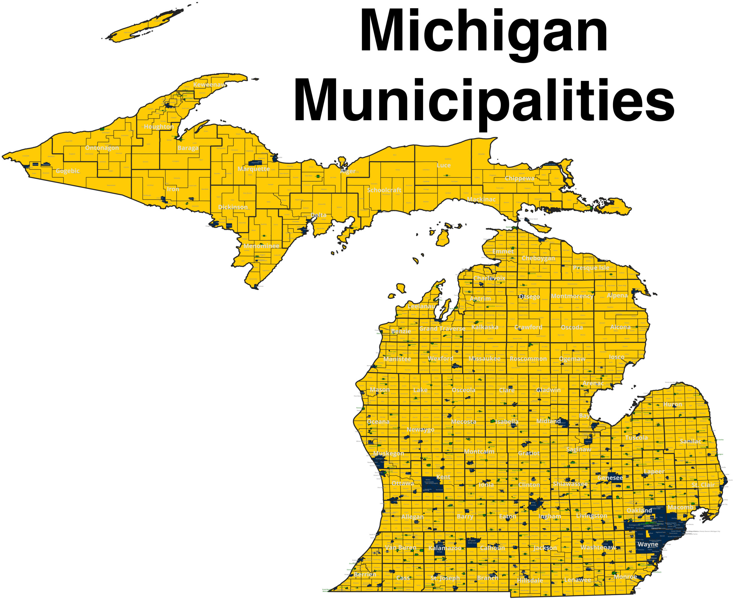
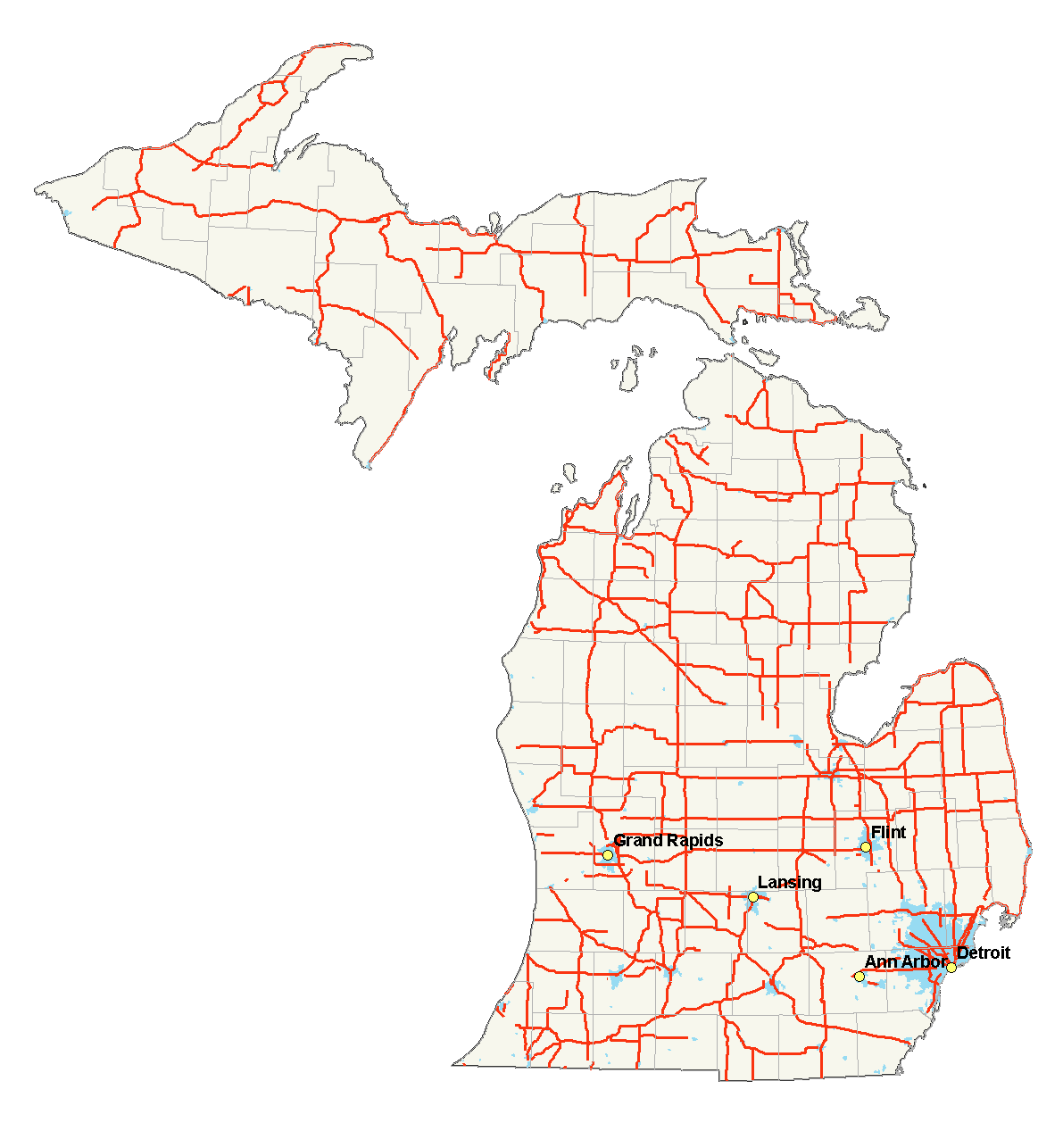
2. Understanding Michigan’s Municipal Hierarchy: Cities vs. Villages vs. Townships
To accurately interpret a Michigan county map showing cities, one must understand how Michigan’s local government structure operates under state statute. Michigan is one of only 20 states in the nation that utilizes a strong civil township system, which divides all county land into distinct administrative units:
A. Incorporated Cities (276 Cities Statewide)
Under Michigan Public Act 279 of 1909 (the Home Rule City Act), an incorporated city is a completely autonomous municipal corporation. When a community incorporates as a city, it automatically severs all political and administrative ties with the township(s) from which its land was carved. Key characteristics of Michigan cities include:
- Complete Township Independence: Residents of a Michigan city do not pay township property taxes, do not vote in township elections, and do not receive township municipal services.
- Direct County Relationship: The city interacts directly with the county government for property tax equalization, county road commission coordination, deed recordation, and circuit court administration.
- Autonomous Public Services: Michigan cities operate their own police departments, fire protection services, municipal water and sewer utilities, and local property assessment rolls.
B. Incorporated Villages (258 Villages Statewide)
Unlike cities, an incorporated village in Michigan remains an integral part of the township (or townships) in which it is geographically situated. Governed by the General Law Village Act (PA 3 of 1895) or the Home Rule Village Act (PA 278 of 1909):
- Dual Taxation & Governance: Village residents pay both village property taxes (for localized services like sidewalks, street lighting, and village parks) and township property taxes (for broad administrative, fire, and library services).
- Voter Participation: Village residents vote in both village municipal elections and township general elections.
- Path to Cityhood: Many historic Michigan communities initially incorporate as villages to secure dense village services, and later transition to full home-rule cities to eliminate double taxation from the surrounding township.
C. Civil & Charter Townships (1,240 Townships Statewide)
Civil townships are the fundamental geographic subdivisions of a Michigan county. Every square inch of land in Michigan that does not fall inside an incorporated city limits is governed by a township:
- General Law Townships: The traditional township form established under the 1846 Revised Statutes, governed by a seven-member township board comprising a Supervisor, Clerk, Treasurer, and four Trustees.
- Charter Townships: Created under the Charter Township Act of 1947 (PA 359), this special status provides growing suburban townships (such as Clinton Township in Macomb County or Canton Township in Wayne County) with enhanced statutory powers, streamlined administrative authority, and greater protection against municipal annexation by neighboring cities.
3. Cross-County Municipalities: Geographic & Jurisdictional Anomalies
One of the most complex cartographic challenges when navigating a map of Michigan counties with cities is identifying municipalities that span multiple county borders. Because Michigan city boundaries can expand through voter annexation or municipal consolidation across county lines, several prominent cities occupy territory in two or more separate counties:
| City Name | Primary County (Main Seat) | Secondary County | Cartographic & Legal Significance |
|---|---|---|---|
| Lansing | Ingham County (Downtown & Capitol) | Eaton County & Clinton County | Michigan’s State Capital. While downtown Lansing, the Capitol building, and City Hall sit in Ingham County, significant residential neighborhoods and commercial developments extend west into Eaton County and north into Clinton County. |
| Holland | Ottawa County (Historic Downtown) | Allegan County | Famed for Tulip Time and Windmill Island. The northern portion (including downtown, Hope College, and Lake Macatawa frontage) lies in Ottawa County; southern commercial and industrial districts lie in Allegan County. |
| Milan | Washtenaw County | Monroe County | Situated along US-23. The northern section falls under Washtenaw County jurisdiction (Ann Arbor court district), while southern portions fall under Monroe County. |
| Richmond | Macomb County | St. Clair County | Located in northern Macomb County, with eastern city boundaries extending across Division Road into Columbus Township in St. Clair County. |
| Northville | Wayne County | Oakland County | Historic downtown Northville sits right along 8 Mile Road (Baseline Road). Southern neighborhoods fall in Wayne County, while northern subdivisions sit in Oakland County. |
| Flat Rock | Wayne County (Downriver) | Monroe County | Centered around the Huron River in southern Wayne County, with southern sections reaching into Berlin Township in northern Monroe County. |
4. Master Michigan City-to-County Directory (Top 100 Municipalities)
This master alphabetical reference directory lists Michigan’s major incorporated cities and population centers, identifying their primary county jurisdiction, county seat status, 2020 Decennial Census population, primary highway connectors, and regional geographic classification:
| City Name | County Jurisdiction | County Seat? | Population (Census) | Major Highways | Region |
|---|---|---|---|---|---|
| Adrian | Lenawee County | Yes | 20,645 | US-223, M-52 | Southeast |
| Allen Park | Wayne County | No | 28,638 | I-94, US-24 (Telegraph) | Metro Detroit |
| Alpena | Alpena County | Yes | 10,197 | US-23, M-32 | Northeast Lower |
| Ann Arbor | Washtenaw County | Yes | 123,851 | I-94, US-23, M-14 | Southeast |
| Auburn Hills | Oakland County | No | 24,360 | I-75, M-59 | Metro Detroit |
| Battle Creek | Calhoun County | No | 52,731 | I-94, I-194, M-66 | Southwest |
| Bay City | Bay County | Yes | 32,661 | I-75, US-10, M-25 | Tri-Cities |
| Benton Harbor | Berrien County | No | 9,103 | I-94, I-196, US-31 | Southwest |
| Berkley | Oakland County | No | 15,194 | M-1 (Woodward), 11 Mile | Metro Detroit |
| Big Rapids | Mecosta County | Yes | 10,273 | US-131, M-20 | Central Lower |
| Birmingham | Oakland County | No | 21,813 | M-1 (Woodward Ave) | Metro Detroit |
| Bloomfield Hills | Oakland County | No | 4,460 | US-24 (Telegraph), M-1 | Metro Detroit |
| Brighton | Livingston County | No | 7,446 | I-96, US-23 | Mid-Michigan / SE |
| Cadillac | Wexford County | Yes | 10,371 | US-131, M-55, M-115 | Northern Lower |
| Canton (Charter Twp) | Wayne County | No | 98,659 | I-275, Michigan Ave (US-12) | Metro Detroit |
| Cheboygan | Cheboygan County | Yes | 4,776 | US-23, M-27 | Northern Lower |
| Clawson | Oakland County | No | 11,389 | I-75, 14 Mile Rd | Metro Detroit |
| Clinton (Charter Twp) | Macomb County | No | 100,512 | M-59 (Hall Rd), Groesbeck | Metro Detroit |
| Coldwater | Branch County | Yes | 10,945 | I-69, US-12 | South Central |
| Dearborn | Wayne County | No | 109,976 | I-94, US-12 (Michigan Ave), M-39 | Metro Detroit |
| Dearborn Heights | Wayne County | No | 63,292 | US-24 (Telegraph), Ford Rd (M-153) | Metro Detroit |
| Detroit | Wayne County | Yes | 639,111 | I-75, I-94, I-96, I-10, M-8, M-102 | Metro Detroit |
| East Lansing | Ingham County | No | 47,741 | I-69, US-127, Grand River (M-43) | Mid-Michigan |
| Eastpointe | Macomb County | No | 34,318 | I-94, Gratiot (M-3), 9 Mile | Metro Detroit |
| Escanaba | Delta County | Yes | 12,240 | US-2, US-41 | Upper Peninsula |
| Farmington | Oakland County | No | 11,597 | M-5, Grand River Ave | Metro Detroit |
| Farmington Hills | Oakland County | No | 83,986 | I-696, I-275, M-5 | Metro Detroit |
| Fenton | Genesee County | No | 12,050 | US-23 | Mid-Michigan / Tri-County |
| Ferndale | Oakland County | No | 19,190 | M-1 (Woodward), 8 Mile, 9 Mile | Metro Detroit |
| Flint | Genesee County | Yes | 81,252 | I-75, I-69, I-475, US-23 | Mid-Michigan / Flint Metro |
| Garden City | Wayne County | No | 27,380 | Ford Rd (M-153), Middlebelt | Metro Detroit |
| Grand Blanc | Genesee County | No | 8,091 | I-75, Saginaw St | Mid-Michigan |
| Grand Haven | Ottawa County | Yes | 11,011 | US-31, M-104 | West Michigan |
| Grand Ledge | Eaton County | No | 7,784 | M-43, I-96 | Mid-Michigan |
| Grand Rapids | Kent County | Yes | 198,917 | I-96, I-196, US-131, M-6 | West Michigan |
| Greenville | Montcalm County | No | 8,816 | M-57, M-91 | Central Lower |
| Grosse Pointe | Wayne County | No | 5,678 | Jefferson Ave, Mack Ave | Metro Detroit |
| Grosse Pointe Woods | Wayne County | No | 16,487 | Mack Ave, Vernier Rd | Metro Detroit |
| Hamtramck | Wayne County | No | 28,433 | I-75, Conant St | Metro Detroit |
| Hazel Park | Oakland County | No | 14,983 | I-75, I-696, 9 Mile | Metro Detroit |
| Highland Park | Wayne County | No | 8,977 | M-1 (Woodward), Davison (M-8) | Metro Detroit |
| Hillsdale | Hillsdale County | Yes | 8,036 | M-99, M-34 | South Central |
| Holland | Ottawa County / Allegan | No | 34,378 | I-196, US-31, M-40 | West Michigan |
| Houghton | Houghton County | Yes | 8,386 | US-41, M-26 | Upper Peninsula |
| Howell | Livingston County | Yes | 10,068 | I-96, Grand River (M-43), M-59 | Mid-Michigan |
| Hudsonville | Ottawa County | No | 7,629 | I-196, M-121 (Chicago Dr) | West Michigan |
| Inkster | Wayne County | No | 26,088 | Michigan Ave (US-12), Middlebelt | Metro Detroit |
| Ionia | Ionia County | Yes | 13,378 | M-66, M-21 | Central Lower |
| Iron Mountain | Dickinson County | Yes | 7,518 | US-2, US-141 | Upper Peninsula |
| Jackson | Jackson County | Yes | 31,309 | I-94, US-127, M-50, M-60 | South Central |
| Kalamazoo | Kalamazoo County | Yes | 73,598 | I-94, US-131, M-43 | Southwest |
| Kentwood | Kent County | No | 54,304 | M-6, 28th St (M-11), US-131 | West Michigan |
| Lansing | Ingham County / Eaton | No (State Capital) | 112,644 | I-96, I-69, I-496, US-127 | Mid-Michigan |
| Lincoln Park | Wayne County | No | 40,245 | I-75, Fort St (M-85), Southfield (M-39) | Metro Detroit |
| Livonia | Wayne County | No | 95,535 | I-96, I-275, Plymouth Rd | Metro Detroit |
| Ludington | Mason County | Yes | 7,655 | US-10, US-31 | West Shore |
| Madison Heights | Oakland County | No | 28,468 | I-75, I-696, 11 Mile | Metro Detroit |
| Marquette | Marquette County | Yes | 20,629 | US-41, M-28 | Upper Peninsula |
| Midland | Midland County | Yes | 42,547 | US-10, M-20 | Tri-Cities |
| Monroe | Monroe County | Yes | 20,462 | I-75, US-24 (Telegraph), M-125 | Southeast |
| Mount Clemens | Macomb County | Yes | 15,697 | I-94, M-3 (Gratiot Ave) | Metro Detroit |
| Mount Pleasant | Isabella County | Yes | 21,688 | US-127, M-20 | Central Lower |
| Muskegon | Muskegon County | Yes | 38,318 | US-31, I-96, Business US-31 | West Michigan |
| Niles | Berrien County / Cass | No | 11,988 | US-31, US-12, M-51 | Southwest |
| Novi | Oakland County | No | 66,243 | I-96, I-696, I-275, M-5 | Metro Detroit |
| Oak Park | Oakland County | No | 29,560 | I-696, M-10 (Lodge), 9 Mile | Metro Detroit |
| Petoskey | Emmet County | Yes | 5,877 | US-31, US-131 | Northern Lower |
| Plymouth | Wayne County | No | 9,301 | M-14, I-275, Ann Arbor Trail | Metro Detroit |
| Pontiac | Oakland County | Yes | 61,606 | M-59, Woodward (M-1), Business US-24 | Metro Detroit |
| Port Huron | St. Clair County | Yes | 28,983 | I-94, I-69, M-25 (Blue Water Bridge) | Thumb / East Coast |
| Portage | Kalamazoo County | No | 48,891 | I-94, US-131, Westnedge Ave | Southwest |
| Rochester | Oakland County | No | 13,035 | M-150 (Rochester Rd), Parkdale | Metro Detroit |
| Rochester Hills | Oakland County | No | 76,300 | M-59, Rochester Rd, Walton Blvd | Metro Detroit |
| Romulus | Wayne County | No | 25,178 | I-94, I-275 (DTW Airport) | Metro Detroit |
| Roseville | Macomb County | No | 47,710 | I-94, I-696, Gratiot (M-3) | Metro Detroit |
| Royal Oak | Oakland County | No | 58,211 | I-75, I-696, Woodward (M-1) | Metro Detroit |
| Saginaw | Saginaw County | Yes | 44,202 | I-75, I-675, M-46, M-13 | Tri-Cities |
| Sault Ste. Marie | Chippewa County | Yes | 13,337 | I-75 (Northern Terminus), M-129 | Upper Peninsula |
| Southfield | Oakland County | No | 76,618 | I-696, M-10 (Lodge), US-24 (Telegraph) | Metro Detroit |
| Southgate | Wayne County | No | 30,014 | I-75, Fort St (M-85), Eureka Rd | Metro Detroit |
| St. Clair Shores | Macomb County | No | 58,874 | I-94, Jefferson Ave (Lake St. Clair) | Metro Detroit |
| St. Joseph | Berrien County | Yes | 7,856 | I-94, Business US-31, M-63 | Southwest |
| Sterling Heights | Macomb County | No | 134,346 | M-59 (Hall Rd), Van Dyke (M-53) | Metro Detroit |
| Taylor | Wayne County | No | 63,409 | I-94, US-24 (Telegraph), Eureka Rd | Metro Detroit |
| Traverse City | Grand Traverse County | Yes | 15,678 | US-31, M-37, M-72 | Northern Lower |
| Trenton | Wayne County | No | 17,944 | Fort St (M-85), West Rd, I-75 | Metro Detroit |
| Troy | Oakland County | No | 87,294 | I-75, Big Beaver Rd (16 Mile) | Metro Detroit |
| Warren | Macomb County | No | 139,387 | I-696, I-75, Van Dyke (M-53), Mound | Metro Detroit |
| Westland | Wayne County | No | 85,420 | Ford Rd (M-153), Wayne Rd, Warren Rd | Metro Detroit |
| Wyandotte | Wayne County | No | 25,058 | Biddle Ave (M-85), Eureka Rd | Metro Detroit |
| Wyoming | Kent County | No | 76,501 | US-131, I-196, M-6, 28th St | West Michigan |
| Ypsilanti | Washtenaw County | No | 20,648 | I-94, US-12 (Michigan Ave), M-17 | Southeast |
| Zeeland | Ottawa County | No | 5,719 | I-196, Business I-196, M-121 | West Michigan |
5. Regional Municipal Profiles: County-by-County Analysis
To analyze how cities cluster across the state, cartographers and economic geographers divide Michigan into six primary geographic regions. Each region exhibits unique municipal patterns dictated by historical settlement routes, Great Lakes deepwater ports, and modern highway logistics:
A. Southeast Michigan & Metro Detroit (The Industrial & Urban Core)
Encompassing Wayne County, Oakland County, and Macomb County, this region represents Michigan’s largest metropolitan economic engine, housing over 3.9 million residents:
- Detroit & The Inner Ring: Centered on Detroit (639,111 residents), the municipal fabric transitions through dense industrial enclaves like Hamtramck and Highland Park before expanding into the mature streetcar suburbs of Dearborn, Lincoln Park, Wyandotte, and Ferndale.
- The Northern Oakland County Corridor: Linked by Woodward Avenue (M-1) and I-75, cities such as Royal Oak, Birmingham, Troy, and Auburn Hills represent major global corporate centers for automotive engineering, healthcare, and robotics.
- Macomb County’s High-Growth Spine: Following Van Dyke Avenue (M-53) and Groesbeck Highway (M-97), Warren (139,387 residents) and Sterling Heights (134,346 residents) form a continuous industrial powerhouse that transitions into the lakeshore communities of St. Clair Shores and New Baltimore on Anchor Bay.
B. West Michigan & Grand Rapids Metro (The Innovation & Lakeshore Hub)
Anchored by Kent County and expanding into Ottawa County, Muskegon County, and Allegan County, West Michigan is the fastest-growing demographic and manufacturing region in the state:
- Grand Rapids & Kent County Cities: Grand Rapids (198,917 residents) anchors the Grand River valley, surrounded by dynamic suburban home-rule cities including Wyoming (76,501), Kentwood (54,304), Walker (25,132), and Grandville (16,083).
- The Lake Michigan Coastal Corridor: Cities like Grand Haven, Holland, Muskegon, and Saugatuck balance commercial Great Lakes shipping and high-tech manufacturing (furniture design, automotive lithium battery production) with premier summer freshwater tourism.
C. Mid-Michigan & The Capitol Corridor
Stretching from Ingham County into Eaton, Clinton, Shiawassee, and Jackson counties, this region blends state governance, higher education, and automotive assembly:
- The Greater Lansing Metropolitan Footprint: Lansing (112,644) houses state administrative agencies and General Motors manufacturing facilities, while adjacent East Lansing (47,741) revolves around Michigan State University’s 50,000-student campus.
- Suburban & Exurban Outposts: Communities like Grand Ledge in Eaton County, St. Johns in Clinton County, and Howell in Livingston County provide commuter corridors feeding both Lansing and Metro Detroit via Interstate 96.
D. The Tri-Cities, Flint & The Thumb
Encompassing Genesee County, Saginaw County, Midland County, Bay County, and the agricultural Thumb counties (Tuscola, Huron, Sanilac, Lapeer, and St. Clair):
- The Vehicle & Chemical Legacy: Flint (81,252) serves as the historic birthplace of General Motors, while Midland (42,547) serves as the global corporate headquarters of Dow Chemical Company along the Tittabawassee River.
- The Saginaw Bay Ports: Saginaw (44,202) and Bay City (32,661) historically developed as lumber and shipbuilding centers, now functioning as major agricultural processing and Great Lakes shipping terminals.
- The Maritime Gateways: Port Huron (28,983) anchors the St. Clair River, serving as the international transit nexus between the US and Canada via the twin spans of the Blue Water Bridge.
E. Northern Lower Peninsula
Comprising Grand Traverse County, Emmet, Charlevoix, Leelanau, Antrim, Otsego, and Wexford counties:
- Traverse City Regional Hub: Traverse City (15,678) serves as the cultural, healthcare (Munson Medical Center), and aviation nexus for northwestern Michigan, situated on the dual arms of Grand Traverse Bay.
- Year-Round Resort & Timber Communities: Petoskey, Harbor Springs, Boyne City, Charlevoix, Gaylord, and Cadillac anchor an outdoor recreation economy centered on skiing, inland lakes, and cherry production.
F. The Upper Peninsula (The U.P.)
Covering Michigan’s 15 northernmost counties separated by the Straits of Mackinac:
- Marquette & The Central Highlands: Marquette (20,629) is the largest city in the Upper Peninsula, home to Northern Michigan University, UP Health System, and active iron ore shipping docks on Lake Superior.
- Border & Historic Mining Towns: Sault Ste. Marie (13,337) borders Ontario at the world-renowned Soo Locks; Escanaba (12,240) anchors Lake Michigan iron docks; and Houghton/Hancock house Michigan Technological University in the historic Copper Country.
6. Practical Applications: Why City & County Boundary Maps Matter
Understanding which city belongs to which county is not merely an academic exercise—it is essential for executing critical legal, financial, civic, and operational tasks across Michigan:
A. Property Taxes, Millage Rates & Equalization
In Michigan, property taxes are determined by multiplying a parcel’s Taxable Value by the combined local millage rates. These millages include state education taxes, local school operating millages, municipal city millages, and county-wide operational and special authority millages (such as SMART public transit in Wayne/Oakland/Macomb, or county veteran affairs millages). If a property buyer mistakes a home in Northville as being entirely in Oakland County when it sits south of 8 Mile Road in Wayne County, their annual property tax assessment and judicial recording fees will be miscalculated by thousands of dollars.
B. 911 Dispatch, Emergency Catchment & Sheriff Jurisdiction
While primary municipal police departments handle calls within city limits, county sheriff departments maintain primary jurisdiction over townships and provide backup dispatch via County Central Dispatch 911 centers. In border emergencies along highways like US-131 between Kent and Allegan counties, or I-275 between Wayne and Oakland counties, automated computer-aided dispatch (CAD) systems rely on precise GIS county-line parcel coordinates to route Michigan State Police (MSP) and local paramedics without delay.
C. Court Venues, Deed Recordings & Legal Notices
Every legal contract involving Michigan real property must be recorded at the Register of Deeds office in the specific county where the physical land lies. Lawsuits, civil disputes, probate petitions, and divorce filings must be filed in the appropriate County Circuit Court (the 3rd Circuit for Wayne, the 6th Circuit for Oakland, the 17th Circuit for Kent, etc.). Submitting a deed for a home in East Lansing to the Clinton County clerk when the parcel is physically situated in Ingham County results in an immediate rejection and clouded title chain.
8. Municipal Annexation, PA 425 Agreements & The State Boundary Commission
A frequent question asked by land developers, commercial brokers, and municipal planners inspecting a Michigan county map with cities is: How do city boundaries expand, and why do some city limits appear irregular on the map? In Michigan, municipal expansion is regulated by specific statutory mechanisms designed to balance urban growth with township property rights:
- The State Boundary Commission (PA 191 of 1968): The State Boundary Commission (SBC) is a state regulatory body housed within the Department of Licensing and Regulatory Affairs (LARA). The commission comprises three statewide members appointed by the Governor, supplemented by two local county commissioners from the specific county where a petition is filed. The SBC reviews and adjudicates all petitions for city incorporation, village incorporation, and contested municipal annexations based on statutory criteria including population density, land use patterns, tax base impact, and municipal service feasibility.
- Public Act 425 Conditional Land Transfers (PA 425 of 1984): Rather than engaging in contentious, expensive annexation lawsuits before the Boundary Commission, Michigan cities and townships frequently utilize Act 425 agreements. Under an Act 425 agreement, a township conditionally transfers economic development territory to an adjacent city for up to 50 years to allow the city to extend municipal water, sanitary sewer, and fire utilities to a commercial or industrial park. In return, the city and township share the resulting property tax revenues based on a negotiated formula. On official cartographic boundary maps, these parcels appear within the city’s operational service perimeter while retaining underlying township survey coordinates.
- Charter Township Annexation Shields: Under the Charter Township Act of 1947, a township that achieves “charter status” and meets minimum statutory standards (maintaining a state-equalized valuation of at least $25 million, providing dedicated police/fire protection, and enacting local zoning) is granted statutory immunity from unilateral annexation by contiguous cities. This legislative protection explains why suburban charter townships in Oakland County, Macomb County, and Kent County have preserved their vast rectangular boundaries despite being completely surrounded by dense home-rule cities.
9. Inter-County Transit Corridors & Educational Catchment Geography
Municipal and county boundaries represent political administrative perimeters, but daily life in Michigan flows across county lines through regional public transportation systems and intermediate school district networks:
A. Regional Transit Authorities & Commuter Corridors
Public transportation in Michigan operates across county boundaries through regional authorities established by the Urban Cooperation Act of 1967 and the Regional Transit Authority (RTA) Act of 2012 (PA 387):
- SMART (Suburban Mobility Authority for Regional Transportation): Serves suburban Wayne County, Oakland County, and Macomb County, operating trunkline bus routes along regional commercial corridors like Gratiot Avenue (M-3), Woodward Avenue (M-1), and Michigan Avenue (US-12), seamlessly bridging the three-county Detroit metropolitan area.
- The Rapid (Interurban Transit Partnership): Serves the six-city Grand Rapids urbanized area across Kent County (Grand Rapids, Wyoming, Kentwood, Walker, Grandville, and East Grand Rapids), operating the state’s first bus rapid transit (BRT) lines (the Silver Line and Laker Line).
- CATA (Capital Area Transportation Authority): Provides multi-county urban and paratransit mobility throughout Ingham County, Eaton County, and Clinton County, linking state government office complexes in Lansing with Michigan State University in East Lansing.
B. School District Boundaries vs. County & City Borders
One of the most common points of confusion for homebuyers and real estate professionals examining a Michigan county map is assuming that school district boundaries match city or county lines. Under the Michigan Revised School Code (PA 451 of 1976), public school districts are independent municipal entities governed by autonomous elected school boards:
- Cross-County School Districts: Over 40% of Michigan’s 537 local public school districts cross municipal or county boundaries. For example, the Northville Public School District encompasses students living in the City of Northville (Wayne County and Oakland County), Northville Township, and portions of Novi and Salem Township in Washtenaw County.
- Intermediate School Districts (ISDs / RESAs): Michigan’s 56 Intermediate School Districts coordinate special education, career technical training, and state reporting across regional clusters of local school districts. While ISDs originally followed single-county borders, consolidation has created multi-county entities like the Eastern Upper Peninsula ISD (serving Chippewa, Mackinac, and Luce counties) and the Copper Country ISD (serving Houghton, Baraga, and Keweenaw counties).
7. Frequently Asked Questions (Michigan Cities & Counties)
Find authoritative answers to the most frequently searched questions regarding Michigan cities, county seats, and municipal boundaries:
What is the largest city in Michigan by population?
Detroit, located in Wayne County, is the largest city in Michigan with an official 2020 Census population of 639,111 residents (with the broader Detroit metropolitan area exceeding 4.3 million residents).
What is the capital city of Michigan, and what county is it in?
Lansing is the capital city of Michigan. The State Capitol building and central government complex are located in Ingham County, though incorporated city boundaries extend west into Eaton County and north into Clinton County.
Are county seats always the largest city in that county?
No. In several Michigan counties, the county seat is a smaller historic municipality rather than the largest commercial city. For example, in Ingham County, the county seat is Mason (population ~8,200), not Lansing. In Macomb County, the seat is Mount Clemens (population ~15,600), while Warren (population ~139,000) and Sterling Heights (population ~134,000) are far larger. In Calhoun County, Marshall is the historic county seat, while Battle Creek is the largest city.
Can a Michigan city be in more than one county?
Yes. Under the Michigan Home Rule City Act, a city may annex contiguous land across county lines. Prominent examples include Lansing (Ingham and Eaton counties), Holland (Ottawa and Allegan counties), Milan (Washtenaw and Monroe counties), and Northville (Wayne and Oakland counties).
What is the difference between a city and a township in Michigan?
In Michigan, an incorporated city is completely independent of the surrounding township. City residents pay city taxes and receive city services. Townships govern all unincorporated county areas outside of cities. Villages remain part of their parent township, meaning village residents pay both village and township taxes.
What is the largest city in Michigan’s Upper Peninsula?
Marquette, the county seat of Marquette County, is the largest city in the Upper Peninsula with a population of 20,629 residents. It serves as the regional hub for healthcare, education (Northern Michigan University), and Lake Superior shipping.
Where can I download printable county maps showing Michigan cities?
You can download high-resolution PDF and PNG maps on our dedicated printable Michigan county map hub, or inspect detailed geographic boundaries on our live interactive Michigan county map explorer.