Upper Peninsula Michigan County Map: Guide to All 15 U.P. Counties, Seats & Time Zones
The complete cartographic reference to Michigan’s Upper Peninsula (the U.P.). Explore all 15 northern counties, county seat municipal directories, Lake Superior and Lake Michigan coastlines, the 4 Central Time Zone jurisdictions, highway corridors, and printable vector PDF maps.
Download Official Upper Peninsula & Michigan County Maps
High-resolution vector PDF downloads showing all 15 Upper Peninsula counties, arterial highways (US-2, US-41, M-28), and municipal county seats.
Michigan Upper Peninsula County Cartographic Map
Michigan’s Upper Peninsula stretches across roughly 320 miles from the Wisconsin border at Ironwood in Gogebic County to Drummond Island in Chippewa County. Bordered on three sides by Lake Superior, Lake Michigan, and Lake Huron, the U.P. constitutes one of North America’s most distinctive geographic and cultural regions.
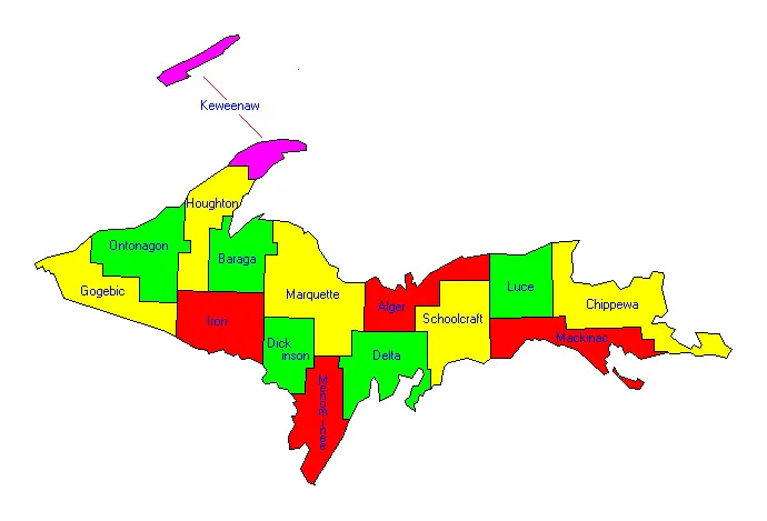
Figure 1: Official cartographic map of the 15 Upper Peninsula counties of Michigan.
Directory of All 15 Upper Peninsula Michigan Counties
Alphabetical breakdown including county seats, population, land area, time zones, shoreline borders, and landmark geography.
| County Name | County Seat | Population | Land Area | Density | Time Zone | Major Water Border | Notable Features & Landmarks |
|---|---|---|---|---|---|---|---|
| Alger County | Munising | 8,769 | 918 sq mi | 9.6 /sq mi | Eastern (EST) | Lake Superior | Pictured Rocks National Lakeshore, Grand Island |
| Baraga County | L’Anse | 8,158 | 904 sq mi | 9.0 /sq mi | Eastern (EST) | Lake Superior (Keweenaw Bay) | Mount Arvon (1,979 ft – Michigan highest point) |
| Chippewa County | Sault Ste. Marie | 36,785 | 1,561 sq mi | 23.6 /sq mi | Eastern (EST) | Lake Superior & Lake Huron | Soo Locks, Drummond Island, Whitefish Point |
| Delta County | Escanaba | 36,903 | 1,171 sq mi | 31.5 /sq mi | Eastern (EST) | Lake Michigan (Bays de Noc) | Fayette Historic State Park, Escanaba River |
| Dickinson County | Iron Mountain | 25,947 | 761 sq mi | 34.1 /sq mi | Central (CST) | Inland (Menominee River) | Pine Mountain Ski Jump, Menominee River State Forest |
| Gogebic County | Bessemer | 14,380 | 1,102 sq mi | 13.0 /sq mi | Central (CST) | Lake Superior | Western Gateway, Copper Peak, Ottawa National Forest |
| Houghton County | Houghton | 37,361 | 1,012 sq mi | 36.9 /sq mi | Eastern (EST) | Lake Superior | Michigan Technological University, Portage Lake Lift Bridge |
| Iron County | Crystal Falls | 11,631 | 1,166 sq mi | 10.0 /sq mi | Central (CST) | Inland (Wisconsin Border) | Iron County Courthouse, over 2,000 lakes & rivers |
| Keweenaw County | Eagle River | 2,172 | 541 sq mi | 4.0 /sq mi | Eastern (EST) | Lake Superior | Isle Royale National Park, Brockway Mountain Drive, Copper Harbor |
| Luce County | Newberry | 5,339 | 903 sq mi | 5.9 /sq mi | Eastern (EST) | Lake Superior | Tahquamenon Falls State Park, Crisp Point Lighthouse |
| Mackinac County | St. Ignace | 10,834 | 1,022 sq mi | 10.6 /sq mi | Eastern (EST) | Lake Michigan & Lake Huron | Mackinac Bridge Gateway, St. Ignace, Les Cheneaux Islands |
| Marquette County | Marquette | 66,017 | 1,808 sq mi | 36.5 /sq mi | Eastern (EST) | Lake Superior | Northern Michigan University, Presque Isle, Sugarloaf Mountain |
| Menominee County | Menominee | 23,502 | 1,044 sq mi | 22.5 /sq mi | Central (CST) | Lake Michigan (Green Bay) | Southernmost U.P. county, Marinette WI border twin cities |
| Ontonagon County | Ontonagon | 5,811 | 1,311 sq mi | 4.4 /sq mi | Eastern (EST) | Lake Superior | Porcupine Mountains Wilderness, Lake of the Clouds |
| Schoolcraft County | Manistique | 8,047 | 1,178 sq mi | 6.8 /sq mi | Eastern (EST) | Lake Michigan | Kitch-iti-kipi (The Big Spring), Seney National Wildlife Refuge |
Geographical Highlights of Michigan’s Upper Peninsula
1. The 4 Central Time Zone Counties
While almost all of Michigan observes Eastern Time (EST/EDT), four counties in the western Upper Peninsula—Gogebic, Iron, Dickinson, and Menominee—observe Central Time (CST/CDT). These counties border Wisconsin along the Menominee and Montreal rivers, sharing trade, school districts, and television broadcast markets with Wisconsin neighbors.
2. Marquette County: The Regional Hub
Marquette County is by far the most populated and economically influential county in the Upper Peninsula. With 66,017 residents, Marquette is home to Northern Michigan University, UP Health System, major iron ore shipping docks on Lake Superior, and over 1,800 square miles of dense forest terrain.
3. The Keweenaw Peninsula & Copper Country
Jutting northward into Lake Superior, the Copper Country comprises Houghton County and Keweenaw County. Keweenaw is Michigan’s least populated county (2,172 residents) but holds historical fame for America’s 19th-century copper boom and contains Isle Royale National Park, located 56 miles offshore in Lake Superior.
4. The Straits of Mackinac & Eastern Gateway
At the eastern end, Mackinac County and Chippewa County guard the legendary water passageways between the Great Lakes. The five-mile Mackinac Bridge connects St. Ignace in Mackinac County to Mackinaw City in the Lower Peninsula, while the historic Soo Locks in Sault Ste. Marie lift 1,000-foot freighters 21 feet between Lake Huron and Lake Superior.
Navigating the Upper Peninsula: Primary Highway Arterials
Because the Upper Peninsula has no interstate highways (I-75 terminates at the Canadian border in Sault Ste. Marie), the region relies on major US and Michigan state trunklines:
- US Highway 2 (US-2): The southern lifeline of the U.P., spanning from the Mackinac Bridge at St. Ignace westward along Lake Michigan through Manistique, Escanaba, and Iron Mountain, reaching Ironwood on the Wisconsin border.
- US Highway 41 (US-41): Originating at the Menominee border with Wisconsin, running north through Escanaba and Marquette, ascending through the Keweenaw Peninsula to its northern terminus at Copper Harbor.
- M-28: The central East-West route running 290 miles from Wakefield near Ironwood through Marquette and Munising (Pictured Rocks) across the Seney Stretch to Chippewa County.
- Interstate 75 (I-75): Crosses the Mackinac Bridge and travels north through Mackinac and Chippewa counties directly to the International Bridge in Sault Ste. Marie.
Explore Related Michigan County Map Pages
Browse our full suite of interactive directories, statewide population rankings, and cartographic maps:
Geological Foundations & The Historic Mining Ranges of the UP
The cartography of Michigan’s Upper Peninsula reflects an extraordinary geological heritage that sharply distinguishes it from the sedimentary basin of the Lower Peninsula. Sitting largely atop the southern margin of the Precambrian Canadian Shield, the bedrock of the western and central UP features volcanic basalts, rhyolites, banded iron formations, and Jacobsville sandstones that formed between 1.1 and 2.7 billion years ago during the Midcontinent Rift system. These monumental geological upheavals laid down the immense mineral reserves that drove the industrialization of the United States throughout the nineteenth and twentieth centuries.
The Three Historic Iron Ranges of Northern Michigan:
- Marquette Iron Range (Marquette County): Discovered in 1844 near Negaunee by surveyor William A. Burt, this range was the birthplace of Great Lakes commercial iron mining. Deep underground shafts gave way to massive open-pit extraction operations such as the Empire and Tilden mines. Today, iron ore is processed into high-grade taconite pellets and transported by specialized Lake Superior and Ishpeming (LS&I) railroad trains directly to the towering Presque Isle ore docks in Marquette harbor for freighter shipment to Lower Great Lakes steel mills.
- Menominee Iron Range (Dickinson & Iron Counties): Opened in the 1870s across Iron Mountain, Norway, Vulcan, and Iron River, the Menominee Range extracted immense veins of rich hematite and limonite. To overcome dangerous groundwater inundation in deep shafts, engineers constructed the famous Cornish Pump at the Chapin Mine in Iron Mountain—a marvel of Victorian steam machinery with a 40-foot flywheel capable of pumping over 3,000 gallons per minute.
- Gogebic Iron Range (Gogebic County): Extending across Ironwood, Bessemer, and Wakefield into northern Wisconsin, the Gogebic Range triggered an aggressive mining speculative boom during the mid-1880s, establishing deep-shaft iron operations that supported thriving multi-ethnic immigrant mining communities for nearly a century.
The Keweenaw Copper Country (Keweenaw, Houghton & Ontonagon Counties):
The Keweenaw Peninsula hosts the planet’s premier deposits of native copper—pure elemental red metal requiring no smelting extraction. Triggered by Douglass Houghton’s 1841 geological report, thousands of Cornish, Finnish, German, and Croatian hardrock miners converged on the peninsula during the Copper Boom of the 1840s, predating the California Gold Rush. Mega-corporations like the Calumet and Hecla Mining Company excavated shafts plummeting over 9,000 feet inclined depth, wiring America’s electric grid and municipal power systems.
How Michigan Acquired the Upper Peninsula: The Toledo War Compromise
One of the most consequential chapters in American cartographic history is how the Upper Peninsula became an integral part of Michigan rather than neighboring Wisconsin. In 1835, Michigan Territory and the State of Ohio engaged in a tense, bloodless border confrontation known as the Toledo War. Both governments laid claim to the “Toledo Strip,” a 468-square-mile wedge of fertile agricultural land containing the strategic commercial mouth of the Maumee River along Lake Erie.
Tensions reached a fever pitch with the deployment of rival state militias along the Maumee River. However, President Andrew Jackson recognized that Ohio’s substantial electoral votes were essential in the upcoming 1836 presidential election, leaving Michigan’s territorial ambitions in political jeopardy. To broker a peaceful resolution, Congress enacted the Northern Ohio Boundary Bill in June 1836. Under the terms of this historic compromise, Michigan conceded the Toledo Strip to Ohio; in compensation, Congress granted Michigan full sovereign jurisdiction over the western three-quarters of the Upper Peninsula, extending from the St. Marys River to the Montreal and Menominee Rivers.
Although contemporary Michigan delegates initially decried the agreement—deriding the UP as an uninhabitable subarctic wasteland of tamarack swamps and barren rock—the discovery of the world’s richest copper deposits and limitless iron ranges within the decade made the swap the most lucrative territorial bargain in state history, transforming Michigan into an industrial powerhouse.
Public Lands, Conservation Forests & Wilderness Stewardship
Over 80 percent of the Upper Peninsula is cloaked in dense northern boreal and mixed hardwood forests, with millions of contiguous acres preserved in the public trust. These vast tracts of public land provide crucial habitat for gray wolves, black bears, moose, cougars, bald eagles, and brook trout, while sustaining recreational hunting, fishing, timber harvest, and wilderness hiking:
- Ottawa National Forest: Encompassing nearly one million contiguous acres across Gogebic, Ontonagon, Iron, Houghton, and Baraga counties, offering over 500 named inland lakes, 2,000 miles of clear river streams, and the rugged Sturgeon River Gorge Wilderness.
- Hiawatha National Forest: Spanning approximately 895,000 acres in two distinct eastern and central operational units across Chippewa, Mackinac, Alger, Delta, and Schoolcraft counties, uniquely bordering three Great Lakes: Lake Superior, Lake Michigan, and Lake Huron.
- Porcupine Mountains Wilderness State Park: Encompassing 60,000 acres in Ontonagon and Gogebic counties, the “Porkies” represent the largest stand of virgin old-growth northern hardwoods in the Midwest, crowned by the breathtaking escarpment overlooking Lake of the Clouds.
- Pictured Rocks National Lakeshore: A federally protected 42-mile shoreline sanctuary in Alger County, showcasing multicolored 200-foot sandstone cliffs, pristine sandy beaches, inland dunes, and roaring waterfalls sculpted by Lake Superior waves.
- Isle Royale National Park: Michigan’s premier national park, situated 56 miles offshore in Lake Superior as an isolated wilderness island archipelago in Keweenaw County, celebrated worldwide for the longest-running predator-prey research study between wild wolves and moose.
Upper Peninsula Waterfalls, Hydrography & The Soo Locks Gateway
The dramatic elevation drop from the ancient Precambrian highlands down to the Great Lakes water levels creates more than 300 named waterfalls across the Upper Peninsula, making it a world-renowned destination for hydrological and ecotourism exploration. Flowing over hard basaltic ledges and soft sedimentary sandstones, these cascading river systems sculpted magnificent gorges across Alger, Gogebic, Ontonagon, and Chippewa counties:
Iconic Upper Peninsula Waterfalls:
- Tahquamenon Falls (Chippewa & Luce Counties): Among the largest waterfalls east of the Mississippi River, the Upper Tahquamenon Falls spans over 200 feet across with a sheer drop of nearly 50 feet. The river discharges up to 50,000 gallons of water per second, tinted a distinctive golden amber by natural cedar and hemlock tannins leaching from surrounding northern peatlands.
- Bond Falls & Agate Falls (Ontonagon County): Located along the Middle Branch of the Ontonagon River, Bond Falls drops over 50 feet across a broad series of fractured basalt cascades, maintained with a year-round minimum aesthetic flow by hydroelectric reservoirs.
- Miners Falls & Chapel Falls (Alger County): Deep within Pictured Rocks National Lakeshore, Miners Falls plunges 50 feet over a hard sandstone escarpment into a lush hemlock gorge, while Chapel Falls drops 60 feet into Chapel Basin.
- Presque Isle River Cascades (Gogebic County): Entering Lake Superior at the western boundary of the Porcupine Mountains Wilderness, the Presque Isle River cuts through deep shale gorges forming Manido, Nawadaha, and Manabezho falls.
The Soo Locks: Linchpin of the Great Lakes Maritime Navigation:
At Sault Ste. Marie in Chippewa County, the St. Marys River drops 21 feet over shallow rapids between Lake Superior and Lake Huron. To bypass this barrier, the historic Soo Locks were constructed in 1855. Operated by the U.S. Army Corps of Engineers, the Poe and MacArthur locks elevate and lower 1,000-foot Great Lakes freighters carrying over 80 million tons of raw iron ore, metallurgical coal, low-sulfur grain, and limestone annually. As the sole waterborne corridor connecting Lake Superior mines to Midwestern steel mills, the Department of Homeland Security considers the Soo Locks one of the most critical infrastructure assets in North America.
Frequently Asked Questions: Upper Peninsula Michigan Counties
How many counties are located in Michigan’s Upper Peninsula?
There are exactly 15 counties in the Upper Peninsula of Michigan. In alphabetical order, they are: Alger, Baraga, Chippewa, Delta, Dickinson, Gogebic, Houghton, Iron, Keweenaw, Luce, Mackinac, Marquette, Menominee, Ontonagon, and Schoolcraft.
Which Upper Peninsula counties are in the Central Time Zone?
Four western U.P. counties observe Central Time (CST/CDT): Gogebic, Iron, Dickinson, and Menominee. These four counties border the state of Wisconsin and operate on Central Time to remain synchronized with neighboring commercial centers like Green Bay, Marinette, and Hurley.
What is the largest county in the Upper Peninsula?
Marquette County is the largest county in the Upper Peninsula by both land area (1,808 square miles) and population (approx. 66,017 residents). It contains the city of Marquette, Northern Michigan University, and the U.P.’s largest regional hospital and commercial airport.
What is the smallest county in the Upper Peninsula?
Keweenaw County is the smallest county in the Upper Peninsula by population, with roughly 2,172 residents, and the smallest in land area at 541 square miles. However, including its vast Lake Superior territorial waters, it spans an enormous total area of 5,966 square miles.
What national parks and major attractions are in the U.P. counties?
Key attractions include Isle Royale National Park in Keweenaw County, Pictured Rocks National Lakeshore in Alger County, Tahquamenon Falls in Luce/Chippewa counties, the historic Soo Locks in Chippewa County, Porcupine Mountains Wilderness in Ontonagon County, and Kitch-iti-kipi in Schoolcraft County.