Explore our comprehensive Calhoun County Map guide, delivering an authoritative cartographic, municipal, and transportation directory for one of Southwest Michigan’s most historically distinguished and economically vital regions. Positioned along the bustling Interstate 94 corridor midway between Detroit and Chicago, Calhoun County spans 718.4 square miles of fertile glacial farmland, river valleys, and thriving urban centers. The county encompasses 19 civil townships, the global cereal manufacturing powerhouse of Battle Creek (“Cereal City”), the historic 19th-century architectural jewel of Marshall (the county seat), the collegiate community of Albion, and major industrial logistics hubs. Whether you are researching township assessing records, navigating regional freeways, mapping the confluence of the Kalamazoo and Battle Creek rivers, or planning a visit to Binder Park Zoo or the historic Honolulu House, this comprehensive guide provides verified spatial, demographic, and civic data.
As an essential pillar in Michigan’s food production, defense logistics (Fort Custer), and advanced manufacturing corridor, Calhoun County plays a central role in Great Lakes commerce. Every spatial and municipal dataset on this page has been cross-referenced against the State of Michigan Center for Geographic Information (CGI), the United States Census Bureau TIGER/Line geographic files, and the official Michigan county map cartographic framework.
1. Official Calhoun County Map Gallery & Locator
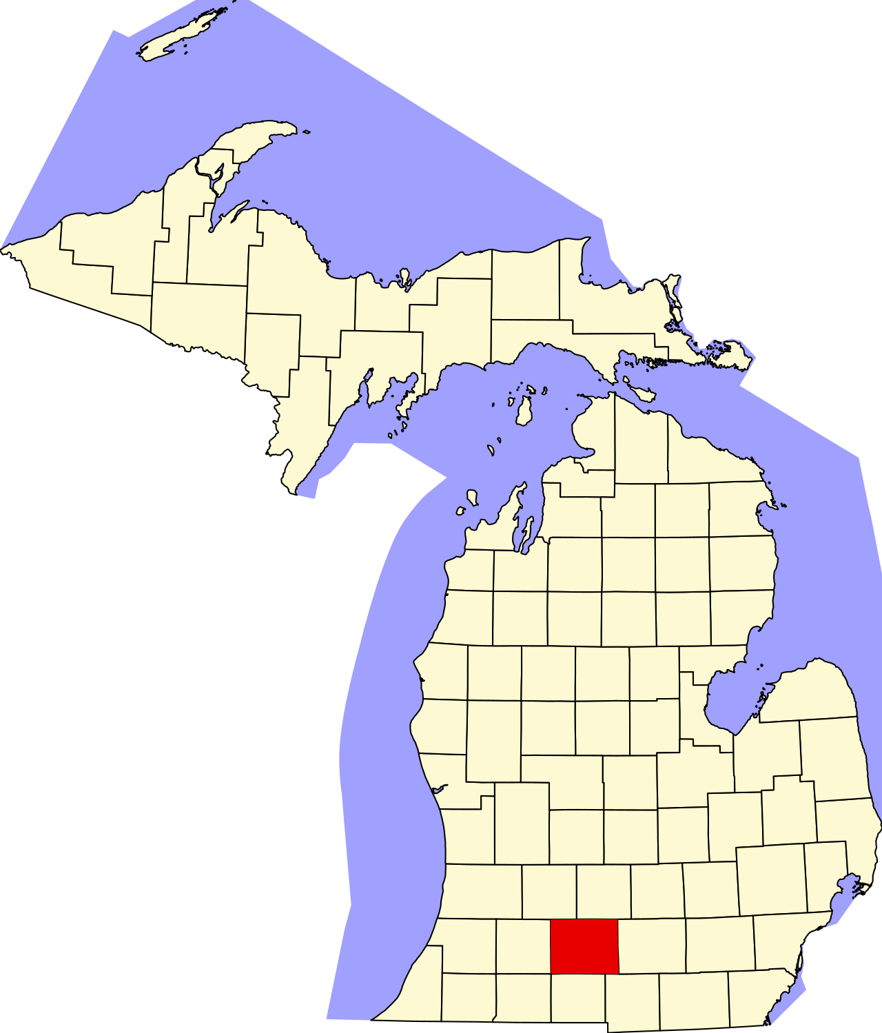
Below is the authentic United States Census Bureau and State GIS locator map depicting Calhoun County highlighted within Michigan’s southern Lower Peninsula:
2. Calhoun County Geographic & Civic Profile (FIPS 26025)
This master administrative summary outlines the primary civic, demographic, and territorial benchmarks for Calhoun County, Michigan:
| Administrative Benchmark | Verified Value & Data Point | Cartographic & Legal Context |
|---|---|---|
| State & Region | Michigan (Southwest Lower Peninsula) | Part of the Battle Creek MSA and Kalamazoo-Battle Creek Combined Area |
| County Seat | City of Marshall | County Courthouse located at 161 E. Michigan Ave. |
| Federal FIPS Code | 26025 | US Census Bureau spatial identifier |
| Date Organized | March 6, 1833 | One of Michigan’s historic Cabinet Counties, named for John C. Calhoun |
| Total Area | 718.4 square miles | Land Area: 708.6 sq mi | Water Area: 9.8 sq mi |
| Population (2020 Census) | 134,310 residents | Population Density: ~189.5 persons per sq mi |
| Largest Municipality | City of Battle Creek (52,731 residents) | Followed by Marshall (7,088) and Albion (7,700) |
| Higher Education | Albion College & Kellogg Community College (KCC) | Distinguished liberal arts and regional community college institutions |
| Primary River Systems | Kalamazoo River & Battle Creek River | Historic river confluence located in downtown Battle Creek |
3. Municipal Directory: Cities, Villages & Urban Hubs
Calhoun County features four incorporated cities, four general-law villages, and extensive suburban charter townships:
A. Battle Creek (“The Cereal City”)
Anchoring western Calhoun County, the City of Battle Creek (population 52,731) is the commercial, industrial, and healthcare capital of the county. Globally celebrated as the birthplace of the modern ready-to-eat breakfast cereal industry—pioneered in the late 19th and early 20th centuries by Dr. John Harvey Kellogg, W.K. Kellogg, and C.W. Post—Battle Creek remains a multinational powerhouse in food science, logistics, and defense manufacturing. Key features include:
- W.K. Kellogg Foundation Headquarters: One of the world’s largest philanthropic philanthropic foundations, maintaining its global headquarters in downtown Battle Creek along the Kalamazoo River linear park.
- Fort Custer Industrial Park & Military Training Center: Encompassing over 3,000 acres, this is the largest modern industrial park in the State of Michigan, housing international automotive suppliers (Denso Manufacturing), food logistics centers, and the Fort Custer Training Center (a major training base for the Michigan Army National Guard and federal law enforcement).
- Binder Park Zoo: A world-class 433-acre zoological facility located in southern Battle Creek, renowned for its immersive 50-acre African Wilds exhibit and elevated giraffe-feeding boardwalks.
- Hart-Dole-Inouye Federal Center: A massive historic federal facility in downtown Battle Creek (originally the Battle Creek Sanitarium), housing federal defense logistics agencies and civil service operations.
B. The City of Marshall (The County Seat & National Historic Landmark District)
Located in the geographic center of Calhoun County at the junction of I-94 and I-69, the City of Marshall (population 7,088) is widely recognized as one of the most architecturally significant small towns in the United States. Marshall boasts the largest National Historic Landmark District in a small American city, containing over 850 preserved 19th-century Greek Revival, Italianate, Queen Anne, and Gothic Revival buildings. Highlights include:
- The Honolulu House Museum: Built in 1860 by former US Consul to Hawaii Abner Pratt, this extraordinary residence combines tropical Hawaiian architecture with Victorian Gothic ornamentation, featuring a 100-foot wraparound veranda and historic museum collections.
- The American Museum of Magic: The largest private museum dedicated to the history of magic in the Americas, housing over 250,000 artifacts from Harry Houdini, Howard Thurston, and Blackstone the Magician.
- BlueOval Battery Park Michigan: Situated in Marshall Township just west of the city along I-94, this multi-billion-dollar electric vehicle lithium battery manufacturing campus represents one of the largest economic development investments in Michigan history.
C. The City of Albion (The College Town)
Located in eastern Calhoun County along the Kalamazoo River, Albion (population 7,700) is a vibrant collegiate and historic industrial community. Home to Albion College (established in 1835), a nationally ranked private liberal arts institution, the city features the historic Bohm Theatre, the Whitehouse Nature Center (140 acres of preserved riparian ecosystems along the river), and direct Amtrak passenger rail connectivity on the Wolverine Line.
D. City of Springfield & Incorporated Villages
- Springfield (population 5,292): An incorporated home-rule city completely surrounded by the western portion of Battle Creek, Springfield functions as a vital residential and commercial community with dedicated municipal services.
- Homer (Homer Township): Situated in southeastern Calhoun County along M-60, Homer is an active industrial and agricultural village home to Folk Oil and major metal fabricators.
- Athens (Athens Township): Located in southwestern Calhoun County, Athens preserves rural agricultural roots and serves as the ancestral home of the Pine Creek Reservation of the Nottawaseppi Huron Band of the Potawatomi.
- Tekonsha (Tekonsha Township): Situated at the crossroads of I-69 and historic US-12 (Old Chicago Road), Tekonsha is a charming agricultural and travel service center.
- Burlington (Burlington Township): An agricultural village located in south-central Calhoun County along the St. Joseph River basin.
4. Comprehensive Guide to Calhoun County’s 19 Civil Townships
Calhoun County is subdivided into 19 civil townships administering local governance, tax assessment rolls, and zoning ordinances:
| Township Name | Population (2020) | Land Area (sq mi) | Key Spatial Features & Infrastructure |
|---|---|---|---|
| Albion Township | 1,123 | 33.4 | Surrounds southern City of Albion; Kalamazoo River agricultural valley. |
| Athens Township | 2,554 | 36.1 | Contains Village of Athens, Pine Creek Indian Reservation, M-66 access. |
| Battle Creek Township | 11,845 | 28.2 | Historic township surrounding southern and western Battle Creek suburbs. |
| Bedford Charter Township | 9,264 | 29.8 | North of Battle Creek along M-37; Waubascon Lake, St. Mary’s Lake residential shoreline. |
| Burlington Township | 1,911 | 36.1 | Village of Burlington, Union City border, pastoral farmland. |
| Clarence Township | 1,974 | 34.8 | Duck Lake (627-acre premier all-sports lake), Duck Lake County Park. |
| Clarendon Township | 1,139 | 35.6 | M-60 corridor, St. Joseph River headwaters, agricultural acreage. |
| Convis Township | 1,636 | 36.2 | North of Marshall along I-69; Bellevue border, rolling wooded countryside. |
| Eckford Township | 1,303 | 35.1 | Historic Eckford hamlet, prime grain and corn agriculture, 22 Mile Road corridor. |
| Emmet Charter Township | 11,744 | 32.4 | East of Battle Creek along I-94; commercial retail, Raymond Road, FireKeepers Casino corridor. |
| Fredonia Township | 1,629 | 34.2 | South of Marshall; Lyon Lake (all-sports lake and country club), Cedar Lake. |
| Homer Township | 3,015 | 36.1 | Surrounds Village of Homer; M-60 and M-99 intersection, manufacturing. |
| Lee Township | 1,214 | 36.2 | Northeastern corner of county; Partello hamlet, state game preserves. |
| Leroy Township | 3,712 | 36.4 | South of Battle Creek; Sonoma hamlet, Pine Creek, I-94 to Kalamazoo corridor. |
| Marengo Township | 2,213 | 35.6 | Between Marshall and Albion along historic Michigan Ave; Kalamazoo River greenways. |
| Marshall Township | 3,115 | 32.0 | Surrounds City of Marshall; I-94 / I-69 interchange, BlueOval Battery Park Michigan site. |
| Newton Township | 2,551 | 36.2 | Ceresco area, Nottawa Creek marshes, rural executive housing. |
| Pennfield Charter Township | 9,005 | 36.3 | Northeast of Battle Creek along M-66; Battle Creek River valley, Clear Lake, suburban growth. |
| Sheridan Township | 1,936 | 35.4 | Surrounds northern City of Albion; I-94 Exit 121, historic Montcalm Lake. |
5. Transportation Logistics, Interstates & Rail Networks
Calhoun County’s highway and rail infrastructure makes it one of the premier distribution hubs in the Midwestern United States:
- Interstate 94 (I-94): Bisects Calhoun County from east to west over 32 continuous miles, providing direct freeway transit between Detroit, Ann Arbor, Jackson, Battle Creek, Kalamazoo, and Chicago. I-94 accommodates over 70,000 vehicles daily through Calhoun County.
- Interstate 69 (I-69): Traverses eastern Calhoun County from south to north, intersecting I-94 just east of Marshall. I-69 links the county south to Fort Wayne and Indianapolis, and north to Lansing, Flint, and the Canadian border crossing at Port Huron.
- Interstate 194 (I-194 / Sojourner Truth Freeway): A 3.4-mile freeway spur extending from I-94 directly into downtown Battle Creek, carrying commuter traffic to the Kellogg corporate headquarters and the W.K. Kellogg Foundation.
- Michigan State Highway 66 (M-66): A primary north-south regional highway connecting Calhoun County northward to Ionia and Mount Pleasant, and southward through Athens into Sturgis and the Indiana Toll Road.
- Michigan State Highway 37 (M-37): Connects Battle Creek northwest through Hastings to Grand Rapids.
- High-Speed Passenger Rail (Amtrak Wolverine Line): Both Battle Creek (Battle Creek Transportation Center) and Albion feature active Amtrak stations on the federally designated high-speed corridor between Chicago and Detroit/Pontiac.
6. Industrial Economy, Food Science & Defense Infrastructure
Calhoun County is recognized internationally as an epicenter of advanced food technology, defense logistics, and green automotive battery production:
- Global Food Production: Home to WK Kellogg Co (global cereal manufacturing), Post Consumer Brands, and Archer Daniels Midland (ADM), Battle Creek processes millions of pounds of grain and packaged food products daily.
- Fort Custer Defense Complex: An essential installation comprising the Fort Custer Training Center (National Guard), the Battle Creek Air National Guard Base (110th Wing), and the Hart-Dole-Inouye Federal Center, employing over 4,000 military and civilian personnel.
- Automotive & Clean Energy Innovation: In addition to Tier-1 automotive suppliers in the Fort Custer Industrial Park (Denso, Musashi, II Stanley), the developing BlueOval Battery Park Michigan campus in Marshall Township will manufacture lithium iron phosphate (LFP) battery cells for next-generation electric vehicles, creating thousands of advanced technical jobs.
7. Underground Railroad History & Sojourner Truth Legacy
Calhoun County holds profound significance in American civil rights and abolitionist history:
- Sojourner Truth Monument: Battle Creek was the adopted home of celebrated abolitionist and women’s rights orator Sojourner Truth from 1857 until her death in 1883. A monument in Monument Park and her gravesite in historic Oak Hill Cemetery honor her national legacy.
- The Underground Railroad Nexus: In the 1840s and 1850s, Marshall and Battle Creek served as vital junction stations on the Underground Railroad, where Quaker stationmasters (such as Erastus Hussey) guided thousands of freedom seekers northward to Canada. The historic 1847 “Crosswhite Affair” in Marshall directly influenced national debate leading to the Fugitive Slave Act of 1850.
Additionally, the Calhoun County Public Health Department operates comprehensive regional clinical health centers in Battle Creek and Albion, providing community preventative medicine, drinking water quality testing for private residential water wells, septic system permitting, and environmental sanitation inspections across all 19 civil townships. This inter-agency public health framework guarantees that rural residents in outlying townships like Clarence, Lee, and Burlington receive equal access to essential county health resources.
8. Frequently Asked Questions (Calhoun County Map)
Review these verified answers to the most common geographical and administrative questions regarding Calhoun County, Michigan:
What is the county seat of Calhoun County, Michigan?
The county seat of Calhoun County is the City of Marshall, where the Calhoun County Courthouse, County Administration Building, and circuit courts are located.
What is the largest city in Calhoun County?
Battle Creek is the largest city in Calhoun County, with an official population of 52,731 residents, serving as the commercial and industrial capital of the region.
Why is Battle Creek called the Cereal City?
Battle Creek is nicknamed “Cereal City” because it was the historic birthplace of commercial breakfast cereal manufacturing, founded by food pioneers W.K. Kellogg, Dr. John Harvey Kellogg, and C.W. Post.
How many townships are in Calhoun County?
Calhoun County comprises exactly 19 civil townships, including Battle Creek, Bedford, Emmet, Marshall, Pennfield, and Clarence townships.
Where can I view an interactive map of Calhoun County and all 83 Michigan counties?
You can explore all 83 Michigan counties with satellite imagery, zoom controls, and demographic data on our live interactive Michigan county map explorer, or download clean PDF study sheets on our printable Michigan county map hub.
9. Spatial Profiles & Land Use Across Calhoun County Townships
To provide complete municipal and land use utility for residents, commercial investors, and civil researchers, the following profiles examine Calhoun County’s suburban, agricultural, and recreational townships:
1. Bedford Charter Township (T1S, R8W)
Forming the northern suburban fringe of Battle Creek, Bedford Charter Township (9,264 residents) is a vibrant residential community. Traversed by North Avenue (M-37), the township features charming lakefront living on St. Mary’s Lake and Waubascon Lake. The township preserves rolling wooded hills and glacial kettle topography while providing convenient commuter access to Kellogg Community College and downtown Battle Creek. Public education is served by Battle Creek Public Schools and Pennfield Schools.
2. Emmet Charter Township (T2S, R7W)
Positioned immediately east of Battle Creek along Interstate 94, Emmet Charter Township (11,744 residents) is the primary retail and entertainment hub of eastern Calhoun County. The township contains major shopping corridors along Columbia Avenue and Michigan Avenue, as well as the FireKeepers Casino Hotel resort campus, operated by the Nottawaseppi Huron Band of the Potawatomi. The Kalamazoo River meanders through the heart of the township, offering linear park trails and public kayak launches. Students attend Harper Creek Community Schools.
3. Pennfield Charter Township (T1S, R7W)
Located northeast of Battle Creek along the scenic M-66 highway corridor, Pennfield Charter Township (9,005 residents) balances mature residential subdivisions with agricultural open space. The township is characterized by the Battle Creek River watershed, Clear Lake, and dense hardwood forests. Pennfield Community Schools operates modern elementary, middle, and high school facilities located on a central educational campus along Pennfield Road.
4. Marshall Township (T2S, R6W)
Surrounding the City of Marshall, Marshall Township (3,115 residents) occupies one of the most strategic transportation junctions in southern Michigan at the intersection of I-94 and I-69. The township features fertile grain acreage, historic Greek Revival farmhouses, and the Marshall Mega-Site (BlueOval Battery Park Michigan). The Kalamazoo River traverses the southern portion of the township, supporting diverse aquatic wildlife. Public education is served by the Marshall Public Schools district.
5. Clarence Township & Duck Lake (T1S, R4W)
Positioned in the northeastern corner of Calhoun County bordering Eaton and Jackson counties, Clarence Township (1,974 residents) is celebrated for Duck Lake, a premier 627-acre spring-fed inland lake. Duck Lake County Park features public sandy beaches, boat ramps, and historic stone picnic pavilions. The township maintains strict conservation zoning, preserving historic oak savannas and agricultural homesteads. Students attend Springport, Mar Lee, or Albion schools.
6. Leroy Township & Sonoma (T3S, R8W)
Situated south of Battle Creek along the I-94 corridor toward Kalamazoo County, Leroy Township (3,712 residents) encompasses the historic settlement of Sonoma. Crossed by Beaver Creek and Pine Creek, the township offers rolling country estates and active dairy farming. Families attend the Harper Creek or Climax-Scotts school districts.
10. River Watersheds, Glacial Geology & Linear Parks
Calhoun County’s physical landscape was shaped by the recessional moraines of the Michigan and Saginaw ice lobes during the late Pleistocene epoch:
- The Kalamazoo River Corridor: The primary hydrological artery of Calhoun County enters from Jackson County through Albion, flows westward through Marengo and Marshall, converges with the Battle Creek River in downtown Battle Creek, and continues into Kalamazoo County. The river provides exceptional recreational kayaking and supports the 20-mile Calhoun County Linear Park trail network.
- The Battle Creek River: Rising in northern Eaton County, the Battle Creek River flows southwest through Pennfield Township before meeting the Kalamazoo River in Battle Creek. The river historically provided water power for the flour mills and cereal processing factories that founded the city.
- Kalamazoo Nature Preserves: Notable protected wildlife habitats include the Ott Biological Preserve (a 300-acre county preserve in Emmet Township featuring rare wetland fens and spring-fed lakes) and the Kimball Pines County Park, renowned for its towering virgin red pine groves.
11. Public Safety, Emergency Dispatch & Educational Networks
Calhoun County maintains a comprehensive, inter-agency public safety and regional educational service framework:
- Calhoun County Consolidated Dispatch Authority (CCCDA): Headquartered in Marshall, the CCCDA coordinates 911 emergency communications across 18 fire departments, 7 police agencies, the Calhoun County Sheriff’s Department, and emergency medical services (LifeCare Ambulance).
- Calhoun Intermediate School District (CISD): Located in Marshall, the CISD coordinates special education services, curriculum development, and vocational instruction (Calhoun Area Career Center) for eight local public school districts: Albion, Battle Creek, Harper Creek, Homer, Lakeview, Mar Lee, Marshall, and Pennfield.
- Higher Education & Workforce Development: Kellogg Community College (KCC), founded in 1956, serves over 8,000 students on its 52-acre main campus in Battle Creek and regional centers in Albion, featuring the state-of-the-art Miller Physical Education Building and the Davidson Visual and Performing Arts Center. Albion College provides nationally distinguished undergraduate education, renowned for its Gerald R. Ford Institute for Public Policy and Service.
7. Marengo Township & The Historical Corridor (T2S, R5W)
Situated in central Calhoun County along the historic Michigan Avenue corridor between Marshall and Albion, Marengo Township (2,213 residents) is defined by deep agricultural roots and riparian greenways. The Kalamazoo River winds through the township, supporting diverse aquatic wildlife, historic stone railroad culverts, and family-owned grain farms. Marengo preserves its historic 1840s township hall and maintains active land conservation partnerships. Students attend Marshall or Albion school districts.
8. Homer Township & The Agricultural Heartland (T4S, R4W)
Positioned in southeastern Calhoun County, Homer Township (3,015 residents) surrounds the incorporated Village of Homer. Operating at the junction of state routes M-60 and M-99, the township combines extensive row-crop agriculture and livestock production with industrial precision machining. The South Branch of the Kalamazoo River flows through the township, providing scenic millpond vistas and public parks. Families are served by the Homer Community School District.
9. Fredonia Township & Lyon Lake (T3S, R6W)
Located immediately south of Marshall, Fredonia Township (1,629 residents) features an idyllic landscape of glacial kettle lakes and wooded residential acreage. The township is centered around Lyon Lake, a premier 150-acre recreational lake home to the historic Lyon Lake Country Club and public boat launch access. Fredonia maintains strong rural zoning safeguards to preserve its historic farmsteads and oak forests. Children attend Marshall Public Schools.
10. Athens Township & Tribal Sovereignty (T4S, R8W)
Anchoring the southwestern corner of Calhoun County, Athens Township (2,554 residents) holds profound cultural and political significance. The township encompasses the Pine Creek Indian Reservation, the sovereign ancestral homeland of the Nottawaseppi Huron Band of the Potawatomi. The tribal government operates health clinics, community education facilities, and cultural preservation centers in Athens. Crossed by M-66, the township offers prime agricultural acreage and tranquil country living. Students attend Athens Area Schools.
11. Convis Township & Bellevue Basin (T1S, R6W)
Situated in north-central Calhoun County along the Interstate 69 corridor, Convis Township (1,636 residents) is characterized by rolling glacial drumlins, hardwood timber tracts, and agricultural valleys. The township borders Eaton County to the north near the Village of Bellevue. Convis features several natural wetlands and waterfowl habitats protected under Michigan DNR wildlife conservation programs. Public education is served by Marshall, Bellevue, and Pennfield schools.
12. Eckford Township & Historic Agriculture (T3S, R5W)
Centrally located south of Marengo, Eckford Township (1,303 residents) is a peaceful farming township known for high-yield soybean and corn production. The unincorporated hamlet of Eckford functions as a historic rural gathering place along 22 Mile Road. Eckford maintains some of the lowest property tax millages in Calhoun County due to its conservative fiscal management. Children attend Marshall or Homer schools.
13. Burlington Township & St. Joseph River (T4S, R7W)
Forming Calhoun County’s southern border with Branch County, Burlington Township (1,911 residents) surrounds the historic Village of Burlington. The township sits within the upper watershed of the St. Joseph River, featuring meandering river channels, productive cattle farms, and historic 19th-century farm architecture. Local children attend Union City Community Schools or Tekonsha Community Schools.
12. The Birthplace of Michigan Public Education & Legal History
Beyond its industrial and abolitionist milestones, Calhoun County holds a revered position in American academic history as the intellectual birthplace of the modern American public education system:
- The Marshall Oak & The Michigan Education System (1834): In the summer of 1834, beneath the branches of a grand oak tree on Mansion Street in Marshall, two civic visionaries—attorney Isaac E. Crary and Congregational minister Rev. John D. Pierce—conceived and drafted the constitutional framework for Michigan’s public school system. Inspired by the Prussian educational model, their revolutionary plan established three foundational principles: that public schools should be free, tax-supported, and universally accessible; that education should be overseen by a constitutional State Superintendent of Public Instruction (the first such post in the United States, with Pierce appointed to the role); and that a state university (the University of Michigan) should crown the public system. The historic “Education Oak” marker in Marshall commemorates this watershed event.
- The Historic 1870s Courthouse & County Seat Preservation: In the 1830s, Marshall actively competed to become the permanent capital of the State of Michigan, going so far as to construct a designated “Capitol Hill” mansion district. When Lansing was ultimately chosen as the state capital in 1847 due to its central geographic location, Marshall pivoted its civic energy toward architectural preservation, legal education, and agricultural commerce. Today, the 37th Judicial Circuit Court of Michigan operates in Marshall, maintaining complete probate, criminal, and land title records dating back to territorial statehood in 1833.
- Newton & Sheridan Townships Agriculture: Newton Township (2,551 residents) and Sheridan Township (1,936 residents) encompass vital agricultural corridors in central and eastern Calhoun County. Sheridan surrounds the northern perimeter of the City of Albion, bisected by I-94 at the 28 Mile Road junction. Newton features rolling morainic terrain, the scenic Nottawa Creek trout stream, and large-tract equestrian farms that exemplify Southwest Michigan’s pastoral beauty.
13. Calhoun County GIS Mapping, Parcel Data & Property Assessment
For land surveyors, title attorneys, and real estate professionals navigating Calhoun County property boundaries, spatial data is administered through advanced county GIS and equalization systems:
- Calhoun County Equalization & GIS Department: Headquartered at the county building in Marshall, the Equalization Department maintains computerized digital parcel mapping (ESRI ArcGIS) for all 19 townships and 4 cities. Every real property parcel is assigned a unique 12-digit property identification number (PIN) formatted by township code (e.g., 53-xxx-xxx-xx).
- County Register of Deeds: The Calhoun County Register of Deeds office preserves official land records, warranty deeds, mortgages, subdivision plats, and federal tax liens dating back to the county’s 1833 inception. Modern deed recordings are digitized with public online search capabilities.
- Drain Commissioner & Watershed Management: Calhoun County maintains over 350 designated county drains spanning hundreds of miles of agricultural drainage ditches and urban storm channels, ensuring soil stability across low-lying farmlands in Homer, Clarendon, and Tekonsha townships.