
Michigan Watershed Map: River Basins, Great Lakes Drainage Divides & County Hydrologic Guide
Michigan is the hydrologic crown of North America, surrounded by four Great Lakes—Superior, Michigan, Huron, and Erie—and threaded by more than 51,000 miles of river streams and 11,000 inland lakes. Every single square foot of land across Michigan’s eighty-three counties drains into one of these freshwater seas. Understanding watershed boundaries, river drainage basins, and groundwater aquifer dynamics is critical for environmental protection, municipal drinking water management, agricultural irrigation, and world-class sports fisheries. Explore our high-resolution downloadable watershed maps, comprehensive 83-county river basin directory table, and aquatic conservation guides below.
Download Official Michigan Watershed & County Basemap PDFs
Access high-resolution vector PDF and PNG map downloads calibrated at 300 DPI for standard Letter (8.5″ x 11″) and Tabloid (11″ x 17″) printing, optimized for environmental impact reviews, collegiate hydrology studies, and watershed council planning:
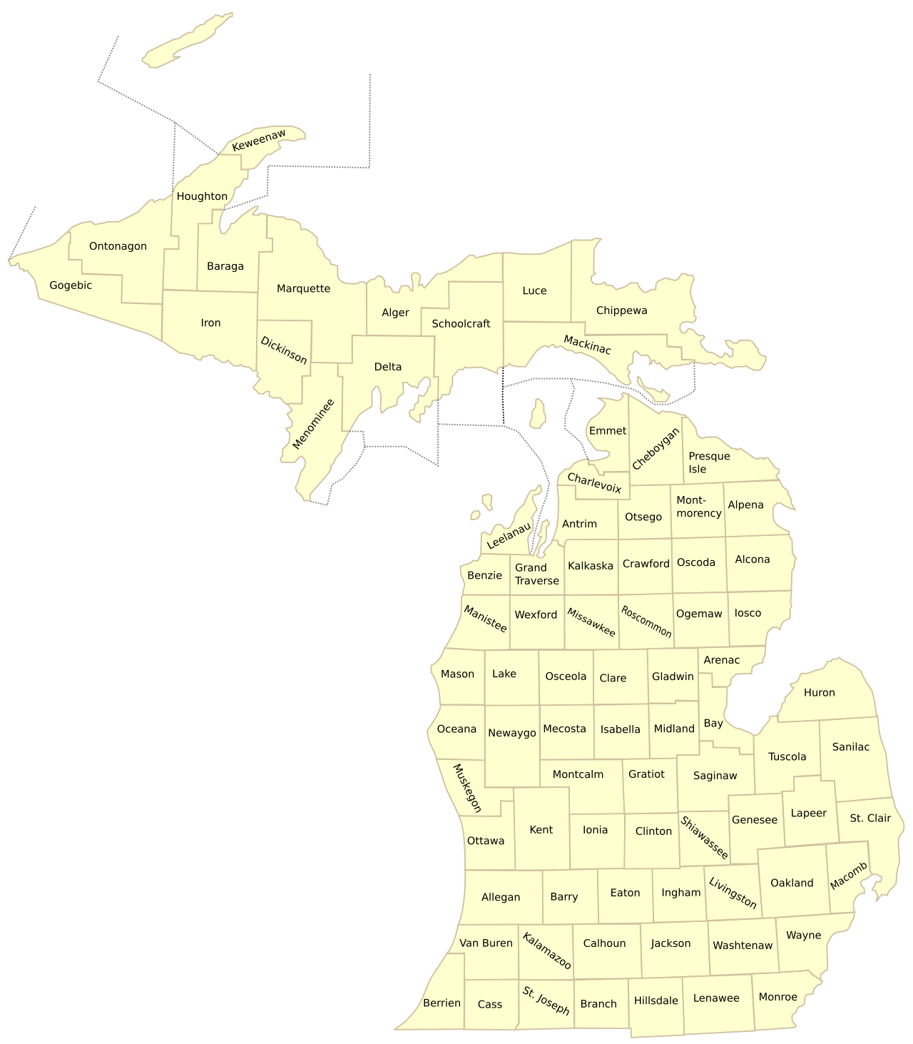
Figure 1: Official cartographic basemap illustrating Michigan’s 83 county boundaries overlaid against the Great Lakes drainage network.
The Great River Basins of Michigan: Geological Sculpture & Hydrography
Following the retreat of the Laurentide Ice Sheet approximately 11,000 years ago, glacial meltwater streams carved monumental glacial valleys through soft morainic till, establishing Michigan’s modern river systems. The state’s landmass is partitioned into several dominant river drainage basins:
Michigan’s Premier River Basins:
- Grand River Watershed (Michigan’s Longest River – 252 Miles): Originating in the glacial wetlands of northern Hillsdale County, the Grand River meanders through Jackson, Ingham, Eaton, Clinton, Ionia, Kent, and Ottawa counties before discharging into Lake Michigan at Grand Haven. Draining 5,572 square miles (over 13 percent of the Lower Peninsula), major tributaries include the Red Cedar, Looking Glass, Maple, Flat, and Thornapple rivers.
- Saginaw River Drainage Basin (Michigan’s Largest Basin – 8,500+ Sq Mi): Covering portions of 22 counties across Mid-Michigan, the Thumb, and Saginaw Bay, the Saginaw River itself is uniquely short (22 miles) but drains the largest watershed in the state. Formed at the Green Point confluence in Saginaw by the union of four major rivers: the Tittabawassee, Shiawassee, Flint, and Cass rivers.
- Kalamazoo River Watershed (130 Miles – 2,020 Sq Mi): Flowing from Hillsdale and Jackson counties through Calhoun, Kalamazoo, and Allegan counties into Lake Michigan at Saugatuck. The lower river basin has been the focus of massive federal Superfund PCB sediment remediations, restoring the river into a thriving fishery for walleye and smallmouth bass.
- Muskegon River Watershed (216 Miles – 2,725 Sq Mi): Originating at Houghton Lake and Higgins Lake in Roscommon County, the Muskegon River flows through Missaukee, Clare, Osceola, Mecosta, Newaygo, and Muskegon counties into Muskegon Lake and Lake Michigan. Impounded by major hydroelectric facilities at Croton and Hardy dams, its cold tailwaters support Michigan’s premier trophy steelhead and Chinook salmon runs.
- St. Joseph River Watershed (206 Miles – 4,685 Sq Mi): Originating in Hillsdale County, the St. Joseph River flows southwest into northern Indiana through Elkhart and South Bend before looping back into Michigan across Berrien County to empty into Lake Michigan at St. Joseph, hosting an innovative interstate fish ladder bypass system.
- Au Sable & Manistee River Watersheds (Northern Blue-Ribbon Trout Giants): The Au Sable River flows east into Lake Huron, globally celebrated as the birthplace of Trout Unlimited and home to the pristine "Holy Waters" fly fishing preserve in Crawford and Oscoda counties. The Manistee River flows west into Lake Michigan, renowned for pristine cedar seepages and cold-water gravel riffles.
- Upper Peninsula River Systems: Dominated by the Menominee River (draining into Lake Michigan / Green Bay and forming the Wisconsin border), the Tahquamenon River (discharging into Whitefish Bay over monumental amber sandstone waterfalls), the Ontonagon River, and the Escanaba River.
The Great Lakes Continental Divides & Water Resources Governance
Under the Great Lakes-St. Lawrence River Basin Sustainable Water Resources Compact (enacted in 2008 by all eight Great Lakes states and two Canadian provinces), all water within Michigan’s watersheds is legally protected from out-of-basin diversions. Rainwater that falls within Michigan cannot be piped or diverted to arid southwestern states, ensuring that Michigan’s freshwater aquifers remain permanently preserved for Great Lakes ecosystems and regional economic prosperity.
At the county level, drainage and stormwater infrastructure is administered by constitutional County Drain Commissioners / Water Resources Commissioners under the Michigan Drain Code (Public Act 40 of 1956). Commissioners oversee thousands of miles of legal drainage districts, inland lake level control dams, and urban retention ponds to prevent catastrophic flooding while filtering agricultural non-point source sediment runoff before it enters the Great Lakes.
County Directory: Major River Systems, Receiving Waters & Watershed Councils
The following master directory indexes all 83 Michigan counties with their primary river networks, receiving Great Lakes drainage basins, and governing regional watershed protection councils:
| County | Primary River & Stream Networks | Receiving Great Lake | Active Watershed Council / Protection Group |
|---|---|---|---|
| Alcona | Au Sable River, Pine River, Black River | Lake Huron | Huron Pines Watershed Council |
| Alger | Miners River, Au Train River, Anna River | Lake Superior | Superior Watershed Partnership |
| Allegan | Kalamazoo River, Black River, Rabbit River | Lake Michigan | Kalamazoo River Watershed Council |
| Alpena | Thunder Bay River, Devils River | Lake Huron | Thunder Bay River Watershed Council |
| Antrim | Chain of Lakes (Intermediate, Elk, Torch), Jordan River | Lake Michigan | The Watershed Center Grand Traverse Bay |
| Arenac | Rifle River, Au Gres River, Saganing River | Lake Huron (Saginaw Bay) | Saginaw Bay Watershed Initiative Network |
| Baraga | Sturgeon River, Falls River, Silver River | Lake Superior (Keweenaw Bay) | Keweenaw Bay Indian Community Natural Resources |
| Barry | Thornapple River, Fall Creek, Augusta Creek | Lake Michigan (via Grand River) | Thornapple River Watershed Council |
| Bay | Saginaw River, Kawkawlin River, Pinconning River | Lake Huron (Saginaw Bay) | Saginaw River Basin Watershed Initiative |
| Benzie | Betsie River, Platte River | Lake Michigan | Betsie River Watershed Council |
| Berrien | St. Joseph River, Paw Paw River, Galien River | Lake Michigan | Friends of the St. Joseph River |
| Branch | Coldwater River, St. Joseph River | Lake Michigan | St. Joseph River Basin Commission |
| Calhoun | Kalamazoo River, Battle Creek River, St. Joseph River | Lake Michigan | Kalamazoo River Watershed Council |
| Cass | Dowagiac River, Christian River, St. Joseph River | Lake Michigan | Dowagiac River Watershed Project |
| Charlevoix | Boyne River, Jordan River, Pine River | Lake Michigan | Tip of the Mitt Watershed Council |
| Cheboygan | Cheboygan River, Black River, Sturgeon River | Lake Huron | Tip of the Mitt Watershed Council |
| Chippewa | St. Marys River, Tahquamenon River, Munuscong River | Lake Superior / Lake Huron | Chippewa Luce Mackinac Conservation District |
| Clare | Tobacco River, Cedar River, Muskegon River | Lake Huron / Lake Michigan | Muskegon River Watershed Assembly |
| Clinton | Looking Glass River, Maple River, Grand River | Lake Michigan (via Grand River) | Grand River Watershed Council |
| Crawford | Au Sable River (Main & North Branches), Manistee River | Lake Huron / Lake Michigan | Au Sable North Branch Area Association |
| Delta | Escanaba River, Ford River, Rapid River, Whitefish River | Lake Michigan (Little Bay de Noc) | Delta Conservation District |
| Dickinson | Menominee River, Sturgeon River, Pine River | Lake Michigan (Green Bay) | Menominee River Watershed Coalition |
| Eaton | Grand River, Thornapple River, Battle Creek River | Lake Michigan | Middle Grand River Organization of Watersheds |
| Emmet | Maple River, Bear River, Minnehaha Creek | Lake Michigan / Lake Huron | Tip of the Mitt Watershed Council |
| Genesee | Flint River, Swartz Creek, Thread Creek | Lake Huron (via Saginaw River) | Flint River Watershed Coalition |
| Gladwin | Tittabawassee River, Cedar River, Sugar River | Lake Huron (via Saginaw River) | Tittabawassee River Basin Commission |
| Gogebic | Montreal River, Black River, Presque Isle River | Lake Superior | Superior Watershed Partnership |
| Grand Traverse | Boardman River (Ottaway), Mitchell Creek | Lake Michigan (Grand Traverse Bay) | The Watershed Center Grand Traverse Bay |
| Gratiot | Pine River, Bad River, Maple River | Lake Huron / Lake Michigan | Pine River Task Force |
| Hillsdale | St. Joseph River, Grand River, Kalamazoo River, Raisin River | Lake Michigan / Lake Erie | Hillsdale County Conservation District |
| Houghton | Sturgeon River, Portage Lake / Canal, Pilgrim River | Lake Superior | Keweenaw Land Trust & Watershed Basin |
| Huron | Pigeon River, Pinnebog River, Willow Creek | Lake Huron (Saginaw Bay) | Huron County Conservation District |
| Ingham | Grand River, Red Cedar River, Sycamore Creek | Lake Michigan (via Grand River) | Mid-Michigan Watershed Council |
| Ionia | Grand River, Flat River, Maple River, Looking Glass River | Lake Michigan | Grand River Watershed Council |
| Iosco | Au Sable River (Lower stem & impoundments), Tawas River | Lake Huron | Huron Pines Watershed Council |
| Iron | Paint River, Michigamme River, Iron River, Net River | Lake Michigan (via Menominee) | Iron County Watershed Protection Group |
| Isabella | Chippewa River, Salt River | Lake Huron (via Saginaw River) | Chippewa Watershed Conservancy |
| Jackson | Grand River (headwaters), Kalamazoo River, Raisin River | Lake Michigan / Lake Erie | Upper Grand River Watershed Alliance |
| Kalamazoo | Kalamazoo River, Portage Creek, Gull Creek | Lake Michigan | Kalamazoo River Watershed Council |
| Kalkaska | Manistee River (headwaters), Rapid River, Boardman River | Lake Michigan | Boardman River Clean Water Alliance |
| Kent | Grand River, Rogue River, Thornapple River, Flat River | Lake Michigan | Lower Grand River Organization of Watersheds |
| Keweenaw | Eagle River, Montreal River (Keweenaw), Gratiot River | Lake Superior | Superior Watershed Partnership |
| Lake | Pere Marquette River (Little South & Baldwin Branches), Pine River | Lake Michigan | Pere Marquette Watershed Council |
| Lapeer | Flint River, Belle River, Mill Creek, Cass River | Lake Huron / Lake St. Clair | Flint River Watershed Coalition |
| Leelanau | Carp River (Leland), Crystal River, Cedar River | Lake Michigan / Grand Traverse Bay | Leelanau Conservancy |
| Lenawee | River Raisin, Macon Creek, Bean Creek | Lake Erie | River Raisin Watershed Council |
| Livingston | Huron River (Chain of Lakes), Shiawassee River, Red Cedar | Lake Erie / Lake Huron | Huron River Watershed Council |
| Luce | Tahquamenon River (Upper & Lower), Two Hearted River | Lake Superior | Superior Watershed Partnership |
| Mackinac | Pine River, Carp River, Brevort River, Millecoquins River | Lake Huron / Lake Michigan | Straits Area Watershed Council |
| Macomb | Clinton River, Red Run, North Branch Clinton River | Lake St. Clair | Clinton River Watershed Council |
| Manistee | Manistee River, Little Manistee River, Pine River | Lake Michigan | Manistee River Watershed Project |
| Marquette | Dead River, Chocolay River, Carp River, Michigamme River | Lake Superior / Lake Michigan | Superior Watershed Partnership |
| Mason | Pere Marquette River, Lincoln River, Sable River | Lake Michigan | Pere Marquette Watershed Council |
| Mecosta | Muskegon River, Little Muskegon River, Chippewa River | Lake Michigan | Muskegon River Watershed Assembly |
| Menominee | Menominee River, Cedar River, Little Cedar River | Lake Michigan (Green Bay) | Menominee Conservation District |
| Midland | Tittabawassee River, Chippewa River, Pine River | Lake Huron (via Saginaw River) | Tittabawassee River Basin Council |
| Missaukee | Clam River, Muskegon River, Manistee River | Lake Michigan | Muskegon River Watershed Assembly |
| Monroe | River Raisin, Huron River, Swan Creek, Stony Creek | Lake Erie | River Raisin Watershed Council |
| Montcalm | Flat River, Fish Creek, Pine River | Lake Michigan / Lake Huron | Flat River Watershed Council |
| Montmorency | Thunder Bay River, Black River, Pigeon River, Hunt Creek | Lake Huron | Thunder Bay Watershed Council |
| Muskegon | Muskegon River, White River, Mona Lake / Black Creek | Lake Michigan | Muskegon River Watershed Assembly |
| Newaygo | Muskegon River, White River, Pere Marquette River | Lake Michigan | Muskegon River Watershed Assembly |
| Oakland | Clinton River, Huron River, Rouge River, Shiawassee River | Lake St. Clair / Lake Erie | Clinton River Watershed Council |
| Oceana | White River, Pentwater River, Stony Creek | Lake Michigan | White River Watershed Partnership |
| Ogemaw | Rifle River, Tittabawassee River | Lake Huron (Saginaw Bay) | Rifle River Watershed Council |
| Ontonagon | Ontonagon River (East, West, Middle, South Branches) | Lake Superior | Ontonagon River Watershed Council |
| Osceola | Muskegon River, Hersey River, Pine River | Lake Michigan | Muskegon River Watershed Assembly |
| Oscoda | Au Sable River (Mainstem, Big Creek) | Lake Huron | Au Sable River Watershed Committee |
| Otsego | Au Sable River, Manistee River, Sturgeon River, Pigeon River | Lake Huron / Lake Michigan | Headwaters Watershed Partnership |
| Ottawa | Grand River, Lake Macatawa / Macatawa River, Pigeon River | Lake Michigan | Lower Grand River Organization of Watersheds |
| Presque Isle | Ocqueoc River, Black River, Swan River | Lake Huron | Huron Pines Watershed Council |
| Roscommon | Muskegon River (Houghton Lake), Au Sable River | Lake Michigan / Lake Huron | Muskegon River Watershed Assembly |
| Saginaw | Saginaw River, Tittabawassee, Shiawassee, Flint, Cass | Lake Huron (Saginaw Bay) | Saginaw River Basin Watershed Initiative |
| St. Clair | St. Clair River, Black River, Pine River, Belle River | Lake Huron / Lake St. Clair | Friends of the St. Clair River |
| St. Joseph | St. Joseph River, Prairie River, Fawn River, Portage River | Lake Michigan | Friends of the St. Joseph River |
| Sanilac | Black River, Cass River, Elk Creek | Lake Huron / Lake St. Clair | Sanilac County Conservation District |
| Schoolcraft | Manistique River, Indian River, Fox River | Lake Michigan | Schoolcraft Conservation District |
| Shiawassee | Shiawassee River, Looking Glass River, Maple River | Lake Huron / Lake Michigan | Friends of the Shiawassee River |
| Tuscola | Cass River, Columbia Drain, Quanicassee River | Lake Huron (Saginaw Bay) | Cass River Greenway Coalition |
| Van Buren | Paw Paw River, Black River, South Branch Black River | Lake Michigan | Two Rivers Coalition |
| Washtenaw | Huron River, River Raisin, Saline River | Lake Erie | Huron River Watershed Council |
| Wayne | Detroit River, Rouge River, Ecorse River, Huron River | Lake Erie / Lake St. Clair | Friends of the Rouge / Friends of the Detroit River |
| Wexford | Manistee River, Pine River, Clam River | Lake Michigan | Manistee River Watershed Partnership |
Frequently Asked Questions: Michigan Watersheds & Rivers
What is the longest river in Michigan?
The longest river in Michigan is the Grand River, flowing 252 miles from northern Hillsdale County through Jackson, Ingham, Eaton, Clinton, Ionia, Kent, and Ottawa counties before emptying into Lake Michigan at Grand Haven.
What is the largest watershed drainage basin in Michigan?
The Saginaw River Basin is Michigan’s largest watershed by drainage area, encompassing over 8,500 square miles across 22 counties. It drains the agricultural heartland of the Saginaw Valley and the Thumb through four primary river tributaries: the Tittabawassee, Shiawassee, Flint, and Cass rivers.
Does any river in Michigan drain into the Mississippi River?
No. Virtually 100 percent of Michigan’s land area drains into the Great Lakes-St. Lawrence River basin. A tiny, negligible sub-watershed in the western Upper Peninsula along the Wisconsin border near Watersmeet drains toward the Wisconsin River, but all major interior Michigan rivers discharge directly into Lake Superior, Lake Michigan, Lake Huron, Lake St. Clair, or Lake Erie.
What is the Great Lakes Basin Compact?
The Great Lakes-St. Lawrence River Basin Sustainable Water Resources Compact is a legally binding interstate and international agreement signed in 2008 by Illinois, Indiana, Michigan, Minnesota, New York, Ohio, Pennsylvania, Wisconsin, Ontario, and Quebec. It bans all new or increased diversions of Great Lakes water outside the natural basin boundaries, with very rare, strictly regulated exceptions for straddling communities.
What is the role of a County Drain Commissioner in Michigan?
Under Michigan law (Public Act 40 of 1956), the elected County Drain Commissioner (or Water Resources Commissioner) is responsible for designing, constructing, financing, and maintaining legal county drainage systems, stormwater detention ponds, and court-established legal lake levels. They protect private property from flooding and enforce soil erosion and sedimentation control standards.
Explore Related Michigan Cartographic & County Resources
- Lower Peninsula Michigan County Map (68 Southern Counties)
- Upper Peninsula Michigan County Map (15 Northern Counties)
- Michigan Public Land Map by County (DNR & Hunting Lands)
- Complete Alphabetical List of All 83 Michigan Counties
- Michigan Highway and County Transportation Map
- Printable Michigan County Map (PDF Downloads)