Michigan County Numbers Map: Official 1 to 83 Numerical County Codes, FIPS & Reference Directory
The State of Michigan utilizes an official 1 to 83 numerical coding system to classify all eighty-three counties in precise alphabetical sequence—ranging from 01 (Alcona County) in the northeast Lower Peninsula down to 83 (Wexford County) in the northwest interior. Originally instituted for uniform state civil governance, public health statistical recordkeeping, and vehicular license registration, these numerical designations remain integral to state administrative operations, Department of Health and Human Services (MDHHS) reporting, court docketing, and geographic information systems (GIS). Explore our high-resolution downloadable numbered maps, complete 83-county directory tables, and comprehensive administrative history below.
Download Official Numbered & Labeled Michigan County Maps
Access high-resolution vector PDF downloads calibrated at 300 DPI for standard Letter (8.5″ x 11″) and Tabloid (11″ x 17″) printing, optimized for state agency research, classroom curriculum instruction, and logistics dispatch:
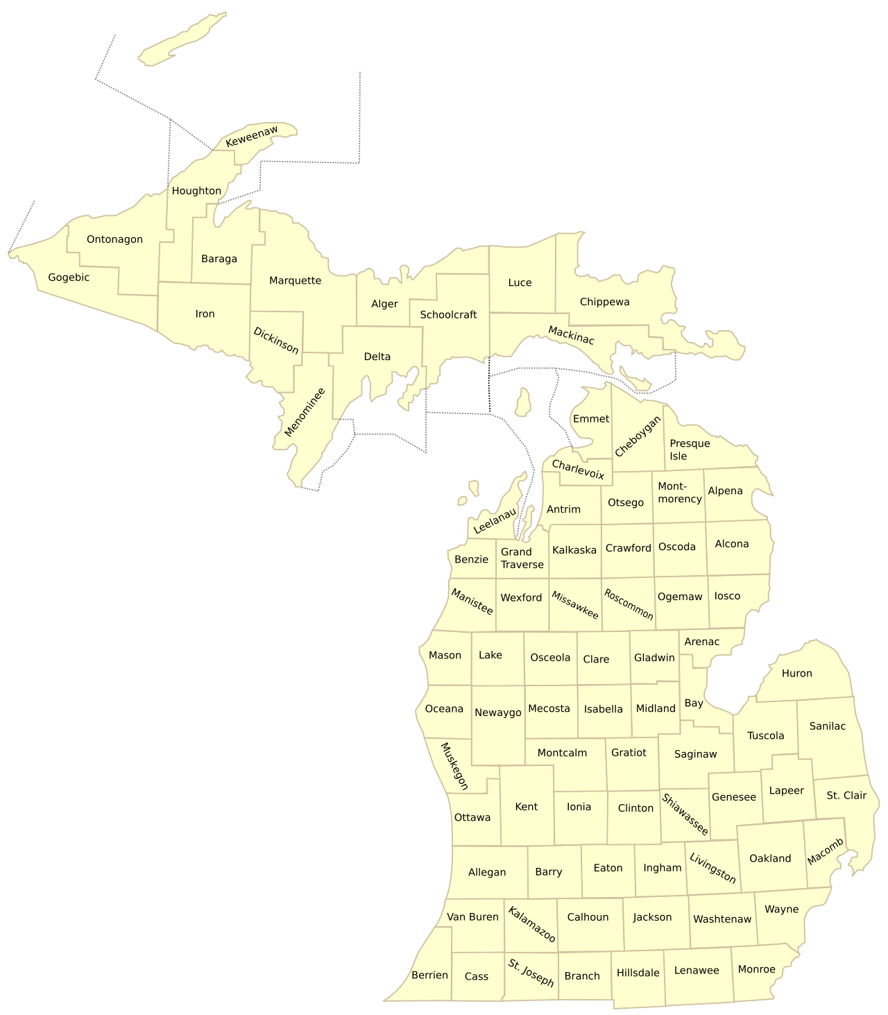
Figure 1: Official cartographic basemap of Michigan’s 83 counties, showing spatial boundaries across the Upper and Lower Peninsulas.
Origins & Architecture of the 1 to 83 Michigan County Numerical System
The establishment of Michigan’s standardized 1 to 83 county numbering system reflects the modernization of state governmental administration during the early twentieth century. Prior to centralized standardization, various executive departments utilized disjointed regional districts, causing administrative inefficiencies across tax collection, public health tracking, and court filings. To resolve these conflicts, state officials established an unyielding alphabetical enumeration based on each county’s legal statutory name.
Under this framework, County Number 1 was assigned to Alcona County, situated along Lake Huron in the northeast Lower Peninsula, while County Number 83 was assigned to Wexford County in the northwestern interior. Because the sequence is strictly alphabetical, counties organized decades apart reside side-by-side on the list: Wayne County (Michigan’s oldest county, established in 1796 under the Northwest Territory) holds number 82, while Dickinson County (Michigan’s newest county, organized in 1891 from portions of Iron, Marquette, and Menominee) holds number 22.
Primary Practical Applications of Michigan County Numbers:
- Historical License Plate Prefixes: Between 1954 and 1983, the Michigan Department of State embossed two-letter county prefix abbreviations and numerical codes directly onto passenger vehicle license plates, allowing law enforcement officers to immediately identify a motorist’s home county of registration.
- Vital Records & Public Health Tracking: The Michigan Department of Health and Human Services (MDHHS) utilizes 1-83 numerical coding on state death certificates, birth registries, and epidemiological communicable disease surveillance reports.
- Court Filing Dockets: Circuit, District, and Probate Court cases across Michigan’s judicial branch utilize county prefix codes to differentiate court filings across jurisdictions.
- Department of Agriculture & Rural Development (MDARD): State food safety inspectors, pesticide applicators, and livestock disease tracking programs index commercial farms and processing plants by numerical county codes.
Correlation with Federal FIPS Codes (Federal Information Processing Standard):
In addition to the state 1-83 numerical code, every Michigan county possesses a standardized 5-digit federal FIPS code assigned by the National Institute of Standards and Technology (NIST) and the U.S. Census Bureau. For Michigan, all FIPS codes commence with the two-digit state prefix 26, followed by a unique 3-digit odd-numbered county identifier (e.g., Alcona is 26001, Alger is 26003, and Wayne is 26163). Because federal FIPS numbers increment by two to accommodate future territorial subdivisions, a simple mathematical relationship exists: subtracting 1 from the 3-digit county FIPS code and dividing by 2 yields its corresponding 1-83 state alphabetical number!
Official Directory: All 83 Michigan Counties by Numerical Code (1 to 83)
The following searchable reference directory details all 83 Michigan counties arranged by their official 1 to 83 alphabetical state number, including county seats, 5-digit federal FIPS codes, geographic regions, latest official census population estimates, and land areas:
| Code | County Name | County Seat | FIPS Code | Geographic Region | Population | Land Area |
|---|---|---|---|---|---|---|
| 01 | Alcona | Harrisville | 26001 | Northern Lower | 10,167 | 674 sq mi |
| 02 | Alger | Munising | 26003 | Upper Peninsula | 8,769 | 918 sq mi |
| 03 | Allegan | Allegan | 26005 | West Michigan | 120,502 | 825 sq mi |
| 04 | Alpena | Alpena | 26007 | Northern Lower | 28,907 | 574 sq mi |
| 05 | Antrim | Bellaire | 26009 | Northern Lower | 23,431 | 477 sq mi |
| 06 | Arenac | Standish | 26011 | Mid-Michigan | 15,002 | 367 sq mi |
| 07 | Baraga | L’Anse | 26013 | Upper Peninsula | 8,158 | 904 sq mi |
| 08 | Barry | Hastings | 26015 | West Michigan | 62,422 | 553 sq mi |
| 09 | Bay | Bay City | 26017 | Great Lakes Bay | 103,856 | 444 sq mi |
| 10 | Benzie | Beulah | 26019 | Northern Lower | 17,970 | 321 sq mi |
| 11 | Berrien | St. Joseph | 26021 | Southwest Michigan | 154,316 | 568 sq mi |
| 12 | Branch | Coldwater | 26023 | Southern Border | 44,862 | 506 sq mi |
| 13 | Calhoun | Marshall | 26025 | Southwest Michigan | 134,310 | 706 sq mi |
| 14 | Cass | Cassopolis | 26027 | Southwest Michigan | 51,589 | 490 sq mi |
| 15 | Charlevoix | Charlevoix | 26029 | Northern Lower | 26,054 | 417 sq mi |
| 16 | Cheboygan | Cheboygan | 26031 | Northern Lower | 25,579 | 715 sq mi |
| 17 | Chippewa | Sault Ste. Marie | 26033 | Upper Peninsula | 36,785 | 1,561 sq mi |
| 18 | Clare | Harrison | 26035 | Central Michigan | 30,856 | 567 sq mi |
| 19 | Clinton | St. Johns | 26037 | Mid-Michigan | 79,128 | 569 sq mi |
| 20 | Crawford | Grayling | 26039 | Northern Lower | 12,988 | 556 sq mi |
| 21 | Delta | Escanaba | 26041 | Upper Peninsula | 36,903 | 1,171 sq mi |
| 22 | Dickinson | Iron Mountain | 26043 | Upper Peninsula (Central Time) | 25,947 | 761 sq mi |
| 23 | Eaton | Charlotte | 26045 | Mid-Michigan | 109,175 | 576 sq mi |
| 24 | Emmet | Petoskey | 26047 | Northern Lower | 34,057 | 468 sq mi |
| 25 | Genesee | Flint | 26049 | Flint / Mid-Michigan | 406,211 | 637 sq mi |
| 26 | Gladwin | Gladwin | 26051 | Central Michigan | 25,386 | 502 sq mi |
| 27 | Gogebic | Bessemer | 26053 | Upper Peninsula (Central Time) | 14,380 | 1,102 sq mi |
| 28 | Grand Traverse | Traverse City | 26055 | Northern Lower | 95,238 | 465 sq mi |
| 29 | Gratiot | Ithaca | 26057 | Central Michigan | 41,761 | 570 sq mi |
| 30 | Hillsdale | Hillsdale | 26059 | Southern Border | 45,742 | 598 sq mi |
| 31 | Houghton | Houghton | 26061 | Upper Peninsula | 37,361 | 1,012 sq mi |
| 32 | Huron | Bad Axe | 26063 | The Thumb | 31,407 | 836 sq mi |
| 33 | Ingham | Mason | 26065 | Capital Region | 284,900 | 556 sq mi |
| 34 | Ionia | Ionia | 26067 | West Michigan | 66,804 | 571 sq mi |
| 35 | Iosco | Tawas City | 26069 | Northern Lower | 25,237 | 549 sq mi |
| 36 | Iron | Crystal Falls | 26071 | Upper Peninsula (Central Time) | 11,631 | 1,166 sq mi |
| 37 | Isabella | Mt. Pleasant | 26073 | Central Michigan | 64,394 | 572 sq mi |
| 38 | Jackson | Jackson | 26075 | South Central Michigan | 160,366 | 707 sq mi |
| 39 | Kalamazoo | Kalamazoo | 26077 | Southwest Michigan | 261,670 | 561 sq mi |
| 40 | Kalkaska | Kalkaska | 26079 | Northern Lower | 17,939 | 560 sq mi |
| 41 | Kent | Grand Rapids | 26081 | West Michigan Hub | 657,974 | 847 sq mi |
| 42 | Keweenaw | Eagle River | 26083 | Upper Peninsula (Copper Country) | 2,172 | 541 sq mi |
| 43 | Lake | Baldwin | 26085 | West Central Michigan | 12,096 | 568 sq mi |
| 44 | Lapeer | Lapeer | 26087 | The Thumb / Metro Fringe | 88,619 | 654 sq mi |
| 45 | Leelanau | Suttons Bay | 26089 | Northern Lower | 22,301 | 347 sq mi |
| 46 | Lenawee | Adrian | 26091 | Southern Border | 99,423 | 750 sq mi |
| 47 | Livingston | Howell | 26093 | Metro Detroit Fringe | 194,385 | 565 sq mi |
| 48 | Luce | Newberry | 26095 | Upper Peninsula | 5,339 | 903 sq mi |
| 49 | Mackinac | St. Ignace | 26097 | Upper Peninsula (Straits) | 10,834 | 1,022 sq mi |
| 50 | Macomb | Mount Clemens | 26099 | Metro Detroit / Lake St. Clair | 881,217 | 479 sq mi |
| 51 | Manistee | Manistee | 26101 | Northern Lower | 25,032 | 542 sq mi |
| 52 | Marquette | Marquette | 26103 | Upper Peninsula Hub | 66,017 | 1,808 sq mi |
| 53 | Mason | Ludington | 26105 | West Michigan Coast | 29,052 | 495 sq mi |
| 54 | Mecosta | Big Rapids | 26107 | Central Michigan | 39,714 | 555 sq mi |
| 55 | Menominee | Menominee | 26109 | Upper Peninsula (Central Time) | 23,502 | 1,044 sq mi |
| 56 | Midland | Midland | 26111 | Great Lakes Bay | 83,494 | 518 sq mi |
| 57 | Missaukee | Lake City | 26113 | Northern Lower | 15,052 | 565 sq mi |
| 58 | Monroe | Monroe | 26115 | Lake Erie Shoreline | 155,274 | 551 sq mi |
| 59 | Montcalm | Stanton | 26117 | Central Michigan | 66,614 | 707 sq mi |
| 60 | Montmorency | Atlanta | 26119 | Northern Lower | 9,153 | 548 sq mi |
| 61 | Muskegon | Muskegon | 26121 | West Michigan Coast | 176,511 | 499 sq mi |
| 62 | Newaygo | White Cloud | 26123 | West Central Michigan | 49,978 | 842 sq mi |
| 63 | Oakland | Pontiac | 26125 | Metro Detroit Hub | 1,274,395 | 868 sq mi |
| 64 | Oceana | Hart | 26127 | West Michigan Coast | 26,585 | 512 sq mi |
| 65 | Ogemaw | West Branch | 26129 | Northern Lower | 20,770 | 563 sq mi |
| 66 | Ontonagon | Ontonagon | 26131 | Upper Peninsula | 5,811 | 1,311 sq mi |
| 67 | Osceola | Reed City | 26133 | Central Michigan | 22,891 | 566 sq mi |
| 68 | Oscoda | Mio | 26135 | Northern Lower | 8,219 | 565 sq mi |
| 69 | Otsego | Gaylord | 26137 | Northern Lower | 25,091 | 515 sq mi |
| 70 | Ottawa | Grand Haven | 26139 | West Michigan Lakeshore | 296,200 | 563 sq mi |
| 71 | Presque Isle | Rogers City | 26141 | Northern Lower | 12,982 | 659 sq mi |
| 72 | Roscommon | Roscommon | 26143 | Northern Lower | 23,459 | 520 sq mi |
| 73 | Saginaw | Saginaw | 26145 | Great Lakes Bay | 189,591 | 800 sq mi |
| 74 | St. Clair | Port Huron | 26147 | Blue Water / The Thumb | 160,383 | 721 sq mi |
| 75 | St. Joseph | Centreville | 26149 | Southern Border | 60,939 | 501 sq mi |
| 76 | Sanilac | Sandusky | 26151 | The Thumb | 40,611 | 963 sq mi |
| 77 | Schoolcraft | Manistique | 26153 | Upper Peninsula | 8,047 | 1,178 sq mi |
| 78 | Shiawassee | Corunna | 26155 | Mid-Michigan | 68,094 | 531 sq mi |
| 79 | Tuscola | Caro | 26157 | The Thumb | 53,323 | 803 sq mi |
| 80 | Van Buren | Paw Paw | 26159 | Southwest Michigan Coast | 75,587 | 607 sq mi |
| 81 | Washtenaw | Ann Arbor | 26161 | Southeast Michigan | 372,258 | 706 sq mi |
| 82 | Wayne | Detroit | 26163 | Metro Detroit Urban Core | 1,793,561 | 597 sq mi |
| 83 | Wexford | Cadillac | 26165 | Northern Lower | 33,673 | 565 sq mi |
Regional Clusters & Distribution of County Numbers Across Michigan
Because Michigan’s 1-83 county codes are ordered alphabetically rather than geographically, county numbers are scattered across both peninsulas. Understanding where specific number ranges appear on the map provides valuable spatial perspective:
Key Regional County Number Patterns:
- The 15 Upper Peninsula Counties: Scattered throughout the alphabetical list, the UP encompasses Code 02 (Alger), 07 (Baraga), 17 (Chippewa), 21 (Delta), 22 (Dickinson), 27 (Gogebic), 31 (Houghton), 36 (Iron), 42 (Keweenaw), 48 (Luce), 49 (Mackinac), 52 (Marquette), 55 (Menominee), 66 (Ontonagon), and 75 (Schoolcraft).
- Southeast Michigan Metropolitan Hubs: Anchored by Code 82 (Wayne County), 63 (Oakland County), 50 (Macomb County), 47 (Livingston County), 58 (Monroe County), and 81 (Washtenaw County). Together, these six counties represent over 4.5 million residents.
- West Michigan Urban & Coastal Corridors: Represented by Code 41 (Kent County / Grand Rapids), 70 (Ottawa County / Holland & Grand Haven), 61 (Muskegon County), 03 (Allegan County), 39 (Kalamazoo County), and 11 (Berrien County).
- Mid-Michigan & Capital District: Encompasses Code 33 (Ingham County / Lansing & Mason), 23 (Eaton County / Charlotte), 19 (Clinton County / St. Johns), and 78 (Shiawassee County / Corunna).
- The Saginaw Bay & Thumb Region: Formed by Code 73 (Saginaw County), 09 (Bay County), 56 (Midland County), 32 (Huron County), 79 (Tuscola County), 76 (Sanilac County), and 74 (St. Clair County).
Cartographic Best Practices: Labeling Maps with County Numbers
When designing printed maps or student worksheets where text space is constrained, utilizing two-digit numerical codes (01 to 83) instead of full county names is an established cartographic best practice. This technique is especially advantageous in densely clustered geographic zones such as Southeast Michigan, where small county polygons (e.g., Wayne, Macomb, Livingston) cannot comfortably accommodate large text labels without obscuring municipal borders and river hydrology.
For academic classrooms following Michigan K-12 Social Studies standards, teachers frequently issue our blank outline maps and instruct students to fill in the official 1 to 83 numbers as an engaging spatial recall quiz. This reinforces student understanding of county locations, geographic regions, and historical territorial settlement patterns.
Frequently Asked Questions: Michigan County Numbers & Codes
What is Michigan County Number 1?
Michigan County Number 1 is Alcona County, situated along Lake Huron in northeastern Lower Michigan with its county seat at Harrisville. Because the official state numbering system is strictly alphabetical, Alcona holds the first numerical position.
What is Michigan County Number 83?
Michigan County Number 83 is Wexford County, located in northwestern Lower Michigan with its county seat at Cadillac. As the final county in alphabetical order, Wexford holds the 83rd code.
What county number is Wayne County (Detroit)?
Wayne County is official Michigan County Number 82. Although it is Michigan’s oldest county (organized in 1796) and most populous county (with nearly 1.8 million residents), its alphabetical ranking places it second to last.
How do Michigan county numbers relate to federal FIPS codes?
Every Michigan county has a 5-digit federal FIPS code starting with ’26’ (Michigan’s state code), followed by an odd 3-digit number. For example, Alcona (County 01) is 26001, Alger (County 02) is 26003, and Wexford (County 83) is 26165. The 1-83 state number represents the exact sequential alphabetical order of these federal FIPS codes.
Were county numbers ever used on Michigan license plates?
Yes. For several decades prior to the mid-1980s, the Michigan Department of State embossed two-letter county prefix codes and registration numbers directly on vehicle license plates. Today, county identification on standard passenger license plates is no longer used, though commercial fleet registrations and tax filings continue to index vehicles by county code.