
Lower Peninsula Michigan County Map: Guide to All 68 Mitten Counties & Regions
The definitive cartographic guide to Michigan’s Lower Peninsula (“The Mitten”). Explore all 68 Lower Peninsula counties, regional economic clusters, Lake Michigan and Lake Huron coastlines, municipal county seats, and printable PDF maps.
Download Official Lower Peninsula County Maps
High-resolution vector PDF downloads showing all 68 Lower Peninsula counties, arterial highways (I-75, I-94, I-96), and county seats.
Lower Peninsula Michigan County Cartographic Map
Michigan’s Lower Peninsula is famously shaped like a mitten, bounded by Lake Michigan to the west, Lake Huron to the east, Lake Erie to the southeast, and the Straits of Mackinac to the north. All 68 counties operate on Eastern Time (EST/EDT) and represent the industrial, agricultural, and cultural heartland of Michigan.
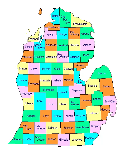
Figure 1: Official cartographic map of the 68 Lower Peninsula counties of Michigan.
Directory of All 68 Lower Peninsula Michigan Counties
Alphabetical breakdown including county seats, population, land area, and geographic sub-regions.
| County Name | County Seat | Population | Land Area | Density | Regional Designation |
|---|---|---|---|---|---|
| Alcona County | Harrisville | 10,167 | 674 sq mi | 15.1 /sq mi | Northern Lower |
| Allegan County | Allegan | 120,502 | 825 sq mi | 146.1 /sq mi | West Michigan |
| Alpena County | Alpena | 28,907 | 574 sq mi | 50.4 /sq mi | Northern Lower |
| Antrim County | Bellaire | 23,431 | 477 sq mi | 49.1 /sq mi | Northern Lower |
| Arenac County | Standish | 15,002 | 367 sq mi | 40.9 /sq mi | Mid-Michigan |
| Barry County | Hastings | 62,422 | 553 sq mi | 112.9 /sq mi | West Michigan |
| Bay County | Bay City | 103,856 | 444 sq mi | 233.9 /sq mi | Great Lakes Bay |
| Benzie County | Beulah | 17,970 | 321 sq mi | 56.0 /sq mi | Northern Lower |
| Berrien County | St. Joseph | 154,316 | 568 sq mi | 271.7 /sq mi | Southwest Michigan |
| Branch County | Coldwater | 44,862 | 506 sq mi | 88.7 /sq mi | Southern Border |
| Calhoun County | Marshall | 134,310 | 706 sq mi | 190.2 /sq mi | Southwest Michigan |
| Cass County | Cassopolis | 51,589 | 490 sq mi | 105.3 /sq mi | Southwest Michigan |
| Charlevoix County | Charlevoix | 26,054 | 417 sq mi | 62.5 /sq mi | Northern Lower |
| Cheboygan County | Cheboygan | 25,579 | 715 sq mi | 35.8 /sq mi | Northern Lower |
| Clare County | Harrison | 30,856 | 567 sq mi | 54.4 /sq mi | Central Michigan |
| Clinton County | St. Johns | 79,128 | 569 sq mi | 139.1 /sq mi | Mid-Michigan |
| Crawford County | Grayling | 12,988 | 556 sq mi | 23.4 /sq mi | Northern Lower |
| Eaton County | Charlotte | 109,175 | 576 sq mi | 189.5 /sq mi | Mid-Michigan |
| Emmet County | Petoskey | 34,057 | 468 sq mi | 72.8 /sq mi | Northern Lower |
| Genesee County | Flint | 406,211 | 637 sq mi | 637.7 /sq mi | Flint / Mid-Michigan |
| Gladwin County | Gladwin | 25,386 | 502 sq mi | 50.6 /sq mi | Central Michigan |
| Grand Traverse County | Traverse City | 95,238 | 465 sq mi | 204.8 /sq mi | Northern Lower |
| Gratiot County | Ithaca | 41,761 | 570 sq mi | 73.3 /sq mi | Central Michigan |
| Hillsdale County | Hillsdale | 45,742 | 598 sq mi | 76.5 /sq mi | Southern Border |
| Huron County | Bad Axe | 31,407 | 836 sq mi | 37.6 /sq mi | The Thumb |
| Ingham County | Mason | 284,900 | 556 sq mi | 512.4 /sq mi | Capital Region |
| Ionia County | Ionia | 66,804 | 571 sq mi | 117.0 /sq mi | West Michigan |
| Iosco County | Tawas City | 25,237 | 549 sq mi | 46.0 /sq mi | Northern Lower |
| Isabella County | Mt. Pleasant | 64,394 | 572 sq mi | 112.6 /sq mi | Central Michigan |
| Jackson County | Jackson | 160,366 | 707 sq mi | 226.8 /sq mi | South Central Michigan |
| Kalamazoo County | Kalamazoo | 261,670 | 561 sq mi | 466.4 /sq mi | Southwest Michigan |
| Kalkaska County | Kalkaska | 17,939 | 560 sq mi | 32.0 /sq mi | Northern Lower |
| Kent County | Grand Rapids | 657,974 | 847 sq mi | 776.8 /sq mi | West Michigan Hub |
| Lake County | Baldwin | 12,096 | 568 sq mi | 21.3 /sq mi | West Central Michigan |
| Lapeer County | Lapeer | 88,619 | 654 sq mi | 135.5 /sq mi | The Thumb / Metro Fringe |
| Leelanau County | Suttons Bay | 22,301 | 347 sq mi | 64.3 /sq mi | Northern Lower |
| Lenawee County | Adrian | 99,423 | 750 sq mi | 132.6 /sq mi | Southern Border |
| Livingston County | Howell | 194,385 | 565 sq mi | 344.0 /sq mi | Metro Detroit Fringe |
| Macomb County | Mount Clemens | 881,217 | 479 sq mi | 1839.7 /sq mi | Metro Detroit / Lake St. Clair |
| Manistee County | Manistee | 25,032 | 542 sq mi | 46.2 /sq mi | Northern Lower |
| Mason County | Ludington | 29,052 | 495 sq mi | 58.7 /sq mi | West Michigan Coast |
| Mecosta County | Big Rapids | 39,714 | 555 sq mi | 71.6 /sq mi | Central Michigan |
| Midland County | Midland | 83,494 | 518 sq mi | 161.2 /sq mi | Great Lakes Bay |
| Missaukee County | Lake City | 15,052 | 565 sq mi | 26.6 /sq mi | Northern Lower |
| Monroe County | Monroe | 155,274 | 551 sq mi | 281.8 /sq mi | Lake Erie Shoreline |
| Montcalm County | Stanton | 66,614 | 707 sq mi | 94.2 /sq mi | Central Michigan |
| Montmorency County | Atlanta | 9,153 | 548 sq mi | 16.7 /sq mi | Northern Lower |
| Muskegon County | Muskegon | 176,511 | 499 sq mi | 353.7 /sq mi | West Michigan Coast |
| Newaygo County | White Cloud | 49,978 | 842 sq mi | 59.4 /sq mi | West Central Michigan |
| Oakland County | Pontiac | 1,274,395 | 868 sq mi | 1468.2 /sq mi | Metro Detroit Hub |
| Oceana County | Hart | 26,585 | 512 sq mi | 51.9 /sq mi | West Michigan Coast |
| Ogemaw County | West Branch | 20,770 | 563 sq mi | 36.9 /sq mi | Northern Lower |
| Osceola County | Reed City | 22,891 | 566 sq mi | 40.4 /sq mi | Central Michigan |
| Oscoda County | Mio | 8,219 | 565 sq mi | 14.5 /sq mi | Northern Lower |
| Otsego County | Gaylord | 25,091 | 515 sq mi | 48.7 /sq mi | Northern Lower |
| Ottawa County | Grand Haven | 296,200 | 563 sq mi | 526.1 /sq mi | West Michigan Lakeshore |
| Presque Isle County | Rogers City | 12,982 | 659 sq mi | 19.7 /sq mi | Northern Lower |
| Roscommon County | Roscommon | 23,459 | 520 sq mi | 45.1 /sq mi | Northern Lower |
| Saginaw County | Saginaw | 189,591 | 800 sq mi | 237.0 /sq mi | Great Lakes Bay |
| Sanilac County | Sandusky | 40,611 | 963 sq mi | 42.2 /sq mi | The Thumb |
| Shiawassee County | Corunna | 68,094 | 531 sq mi | 128.2 /sq mi | Mid-Michigan |
| St. Clair County | Port Huron | 160,383 | 721 sq mi | 222.4 /sq mi | Blue Water / The Thumb |
| St. Joseph County | Centreville | 60,939 | 501 sq mi | 121.6 /sq mi | Southern Border |
| Tuscola County | Caro | 53,323 | 803 sq mi | 66.4 /sq mi | The Thumb |
| Van Buren County | Paw Paw | 75,587 | 607 sq mi | 124.5 /sq mi | Southwest Michigan Coast |
| Washtenaw County | Ann Arbor | 372,258 | 706 sq mi | 527.3 /sq mi | Southeast Michigan |
| Wayne County | Detroit | 1,793,561 | 597 sq mi | 3004.3 /sq mi | Metro Detroit Urban Core |
| Wexford County | Cadillac | 33,673 | 565 sq mi | 59.6 /sq mi | Northern Lower |
The Distinct Sub-Regions of Michigan’s Lower Peninsula
Shaped distinctly like a mitten, Michigan’s Lower Peninsula encompasses 68 counties that demonstrate profound economic, cultural, and geographic diversity. The land is characterized by five primary sub-regions, each shaped by distinct glacial landforms and historical settlement patterns:
Five Functional Lower Peninsula Regional Profiles:
- Southeast Michigan Metro (Wayne, Oakland, Macomb, Livingston, Monroe, Washtenaw): Home to nearly half the state’s population, this economic engine centers on Detroit, Ann Arbor, and Pontiac. It is globally recognized for automotive research and development, advanced robotics, biomedical healthcare systems, and world-class universities like the University of Michigan.
- West Michigan Lakeshore & Urban Hubs (Kent, Ottawa, Muskegon, Allegan, Kalamazoo): Centered around Grand Rapids, Kalamazoo, and Holland, this dynamic region is known for medical device manufacturing, office furniture production (Steelcase, Herman Miller), craft beverage innovation, and vibrant Dutch cultural heritage.
- Mid-Michigan & The Capital Region (Ingham, Eaton, Clinton, Shiawassee): Anchored by the state capital of Lansing and Michigan State University in East Lansing, this region focuses on state governmental governance, agricultural science research, insurance corporate headquarters, and automotive assembly.
- The Saginaw Bay & The Thumb (Saginaw, Bay, Midland, Tuscola, Huron, Sanilac): Formed by the Saginaw River basin and the “Thumb” projecting into Lake Huron, this flat, fertile plain represents Michigan’s richest agricultural heartland, complemented by chemical giant Dow Inc. in Midland and commercial shipping along Saginaw Bay.
- Northern Lower Michigan (Grand Traverse, Charlevoix, Emmet, Leelanau, Otsego, Crawford, etc.): Characterized by rolling glacial moraines, crystal-clear inland lakes, vast state forests, and premier resort destinations like Traverse City and Petoskey, serving as the Midwest’s playground for skiing, boating, and wineries.
Glacial Moraines, Major Watersheds & River Drainage Systems
The physical topography of the Lower Peninsula was entirely sculpted during the Wisconsin Glacial Episode approximately 10,000 to 14,000 years ago. As continental glaciers melted and retreated, they deposited massive belts of glacial till, outwash sand plains, kames, eskers, and kettle lakes that govern modern land use, agriculture, and municipal groundwater supplies:
- Grand River Basin: Michigan’s longest river at 252 miles, originating in Hillsdale County and traversing Jackson, Ingham, Eaton, Clinton, Ionia, Kent, and Ottawa counties before discharging into Lake Michigan at Grand Haven.
- Saginaw River Drainage Basin: Michigan’s largest watershed by drainage area, encompassing over 8,500 square miles across 22 counties via major tributaries including the Tittabawassee, Shiawassee, Flint, and Cass Rivers before entering Saginaw Bay.
- Kalamazoo River Watershed: Flowing 130 miles through Hillsdale, Jackson, Calhoun, Kalamazoo, and Allegan counties into Lake Michigan at Saugatuck, historically powering 19th-century paper mills and modern industrial centers.
- Muskegon River Basin: Flowing 216 miles from Houghton Lake in Roscommon County through Missaukee, Clare, Osceola, Mecosta, Newaygo, and Muskegon counties, celebrated for historic logging drives and hydroelectric impoundments.
Agricultural Specialty Belts of the Lower Peninsula
Thanks to microclimates created by the surrounding Great Lakes, Michigan’s Lower Peninsula boasts the second-most diverse agricultural economy in the United States, second only to California. Understanding these regional agricultural corridors reveals why specific county boundaries thrive with distinct crops:
The West Michigan Fruit Ridge—a unique 20-mile-long elevated glacial ridge sitting 8 miles inland from Lake Michigan across Kent, Ottawa, Muskegon, and Newaygo counties—produces over 60 percent of Michigan’s commercial fresh apples. Meanwhile, the lake-moderated coastal belt along Berrien, Van Buren, and Allegan counties yields abundant commercial blueberries, peaches, juice grapes, and asparagus. In the east, the lacustrine lakebed soils of Huron, Tuscola, and Sanilac counties make Michigan a national leader in sugar beets, navy beans, and dry edible beans.
Lower Peninsula Coastal Dunes, State Parks & Great Lakes Shorelines
Michigan possesses more freshwater coastline than any other political unit on earth, stretching over 3,200 miles. The western flank of the Lower Peninsula contains the world’s largest collection of freshwater coastal sand dunes, formed by prevailing westerly winds depositing glacial sands along the eastern shores of Lake Michigan. These towering dunes and coastal ecosystems represent ecological and recreational treasures preserved across dozens of celebrated state parks:
Premier Lower Peninsula Coastal Preserves:
- Warren Dunes State Park (Berrien County): Rising nearly 260 feet above Lake Michigan, these dramatic dunes offer rugged hiking, hang-gliding launch pads, and three miles of white sand shoreline within an easy drive of Chicago and South Bend.
- Silver Lake Sand Dunes (Oceana County): A 2,000-acre sandbox paradise divided into three dedicated zones: a pristine pedestrian nature sanctuary, a commercial dune scooter concession, and Michigan’s only designated 450-acre off-road vehicle (ORV) dune scramble area.
- Ludington State Park (Mason County): Nestled between Lake Michigan and Hamlin Lake, this 5,300-acre park showcases miles of shifting dunes, the iconic Big Sable Point Lighthouse, and tubing rapids along the Sable River.
- Grand Haven State Park (Ottawa County): Michigan’s most visited beach state park, renowned for its wide quartz-sand beaches, active south pier, and historic red inner and outer range lighthouses.
Inland Lake Giants: Houghton Lake & Higgins Lake:
In the north-central interior of Roscommon County lie two of Michigan’s most famous freshwater lakes. Houghton Lake is Michigan’s largest inland lake by surface area (covering over 20,000 acres / 31 square miles), celebrated for year-round walleye and pike angling and the winter "Tip-Up Town USA" festival. Directly to the north, Higgins Lake is an ultra-deep, spring-fed glacial basin covering nearly 10,000 acres, consistently ranked among the world’s clearest freshwater bodies due to its crystalline sapphire waters and limestone sands.
What are the primary economic and industrial specializations across Lower Peninsula counties?
The Lower Peninsula functions as a multifaceted economic juggernaut. Southeast Michigan (Wayne, Oakland, Macomb) leads the world in connected and autonomous vehicle development, automotive design, and advanced robotics. West Michigan (Kent, Ottawa, Muskegon) is internationally recognized for medical manufacturing, industrial automation, and commercial office furniture production. Mid-Michigan (Ingham, Eaton) anchors state civil governance, insurance headquarters, and major collegiate biotechnology research at Michigan State University, while the Thumb and Saginaw Valley provide high-yield agricultural food security and industrial chemical production.
How does the Lower Peninsula climate compare between the eastern and western coasts?
Due to prevailing westerly winds crossing the open waters of Lake Michigan, the western coastal counties enjoy significantly moderated winter and summer temperatures, supporting delicate fruit orchards while receiving heavy lake-effect snowfalls averaging 80 to 140 inches per season. In contrast, the eastern counties bordering Lake Huron and Lake Erie experience more continental weather patterns with slightly drier winter conditions, less lake-effect snowfall, and greater temperature fluctuations during seasonal transitions.
Frequently Asked Questions: Lower Peninsula Michigan Counties
How many counties are in the Lower Peninsula of Michigan?
The Lower Peninsula contains 68 counties out of Michigan’s 83 total counties. The remaining 15 counties make up the Upper Peninsula.
Are all Lower Peninsula Michigan counties in the Eastern Time Zone?
Yes, 100% of the 68 counties in the Lower Peninsula observe Eastern Time (EST/EDT). The only Michigan counties on Central Time are four counties in the western Upper Peninsula along the Wisconsin border.
What is the most populous county in the Lower Peninsula?
Wayne County is the most populous county with approximately 1,793,561 residents, home to the city of Detroit. It is followed by Oakland County (1.27 million) and Macomb County (881,000).
How does highway traffic travel between the Lower and Upper Peninsulas?
Vehicles travel between the peninsulas across the Mackinac Bridge, a 5-mile suspension bridge carrying Interstate 75 from Mackinaw City (Lower Peninsula) to St. Ignace (Upper Peninsula).