Northern Michigan County Map: Complete Guide to the 21 “Up North” Counties & Vacation Hubs
The ultimate authoritative guide to the 21 counties of Northern Lower Michigan. Explore Traverse City, Petoskey, Sleeping Bear Dunes, Mackinaw City, Lake Michigan beaches, Huron sunrise coasts, state forest trail systems, municipal county seats, and printable PDF maps.
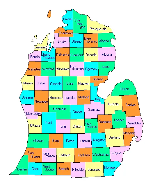
Download Official Northern Michigan County Maps
Download vector PDF maps displaying county lines, scenic highways (M-22, M-119), state forest pathways, and municipal seats.
Defining “Up North”: Geography, Culture & Boundaries
In Michigan folklore, vernacular culture, and tourism cartography, the phrase “Up North” carries deep emotional, recreational, and geographic resonance. While casual travelers often associate Up North with anywhere past their home suburban beltway, professional geographers, state planners, and the Michigan Department of Transportation formally designate Northern Michigan as the northern tier of the Lower Peninsula lying north of the historic Townline road or the US Route 10 corridor (roughly latitude 44 degrees North).
This vast territory encompasses exactly twenty-one administrative counties: Alcona, Alpena, Antrim, Benzie, Charlevoix, Cheboygan, Crawford, Emmet, Grand Traverse, Iosco, Kalkaska, Leelanau, Manistee, Missaukee, Montmorency, Ogemaw, Oscoda, Otsego, Presque Isle, Roscommon, and Wexford. Stretching from the sandy bluffs of Manistee on Lake Michigan across to the rocky limestone reefs of Alpena on Lake Huron, Northern Lower Michigan spans over 11,400 square miles of dense hardwood timberlands, glacial kettle lakes, cold-water trout streams, and over eight hundred miles of pristine Great Lakes freshwater coastline.
The Three Distinct Sub-Regions of Northern Lower Michigan
1. Northwest Lower Michigan (The Gold Coast)
Comprising Grand Traverse, Leelanau, Emmet, Charlevoix, Antrim, Benzie, and Manistee. This region is world-renowned for its Caribbean-blue waters, the massive 450-foot dunes of Sleeping Bear Dunes National Lakeshore, premier viticultural microclimates, historic resort enclaves like Petoskey and Harbor Springs, and the thriving culinary metropolis of Traverse City. It is Northern Michigan’s primary population and economic dynamo.
2. Northeast Lower Michigan (The Sunrise Coast)
Anchored by Alcona, Alpena, Presque Isle, Iosco, and Cheboygan. Facing Lake Huron to the east, the Sunrise Coast offers a more rugged, tranquil, and untamed maritime character. Highlights include the Thunder Bay National Marine Sanctuary (preserving over 200 historic shipwrecks), limestone quarries, maritime lighthouses, deep-water salmon fishing, and quiet harbor towns like Rogers City, Harrisville, and Tawas City.
3. Central Northern Heartland (Lakes & Pine Forests)
Encompassing Otsego, Crawford, Roscommon, Kalkaska, Missaukee, Wexford, Ogemaw, and Oscoda. This interior plateau features immense public state forests (Mackinaw and Au Sable State Forests), Michigan’s premier inland resort waters (Houghton Lake, Higgins Lake, Lake Margrethe), world-class fly fishing on the Au Sable and Manistee rivers, winter snowmobiling networks, and the Alpine Village of Gaylord.
Arterial Corridors: How to Reach Northern Michigan
Reaching Northern Michigan requires traveling along specific north-south highway spines that traverse the state’s interior glacial moraines:
- Interstate 75 (I-75): The eastern freeway spine carrying the vast majority of downstate traffic from Detroit, Flint, and Saginaw directly north through West Branch, Grayling, and Gaylord to Mackinaw City and the Mackinac Bridge.
- US Highway 131 (US-131): The western interior spine running north from Kalamazoo and Grand Rapids through Cadillac, continuing past Kalkaska to Petoskey on Little Traverse Bay.
- US Highway 31 (US-31): The scenic coastal highway tracing Lake Michigan through Manistee, Traverse City, Charlevoix, and Petoskey, terminating at I-75 in Mackinaw City.
- US Highway 23 (US-23): The Heritage Route hugging Lake Huron from Standish through Tawas City, Alcona County, and Alpena to Cheboygan.
- M-72: Michigan’s premier east-west trans-peninsula highway, connecting Empire on Lake Michigan directly to Harrisville on Lake Huron via Traverse City, Kalkaska, and Grayling.
Directory of All 21 Northern Lower Michigan Counties
Exhaustive statistical breakdown of all 21 Up North county jurisdictions, seats, populations, and square mileage.
| County Name | County Seat | Population | Land Area | Water Area | Density | Organized | FIPS |
|---|---|---|---|---|---|---|---|
| Alcona County | Harrisville | 10,167 | 674 sq mi | 1,117 sq mi | 15.1 /sq mi | 1869 | 26001 |
| Alpena County | Alpena | 28,907 | 574 sq mi | 1,121 sq mi | 50.4 /sq mi | 1857 | 26007 |
| Antrim County | Bellaire | 23,431 | 477 sq mi | 125 sq mi | 49.1 /sq mi | 1840 | 26009 |
| Benzie County | Beulah | 17,970 | 321 sq mi | 539 sq mi | 56.0 /sq mi | 1863 | 26019 |
| Charlevoix County | Charlevoix | 26,054 | 417 sq mi | 974 sq mi | 62.5 /sq mi | 1869 | 26029 |
| Cheboygan County | Cheboygan | 25,579 | 715 sq mi | 170 sq mi | 35.8 /sq mi | 1853 | 26031 |
| Crawford County | Grayling | 12,988 | 556 sq mi | 7 sq mi | 23.4 /sq mi | 1879 | 26039 |
| Emmet County | Petoskey | 34,057 | 468 sq mi | 414 sq mi | 72.8 /sq mi | 1853 | 26047 |
| Grand Traverse County | Traverse City | 95,238 | 465 sq mi | 136 sq mi | 204.8 /sq mi | 1851 | 26055 |
| Iosco County | Tawas City | 25,237 | 549 sq mi | 1,342 sq mi | 46.0 /sq mi | 1857 | 26069 |
| Kalkaska County | Kalkaska | 17,939 | 560 sq mi | 11 sq mi | 32.0 /sq mi | 1871 | 26079 |
| Leelanau County | Suttons Bay | 22,301 | 347 sq mi | 2,185 sq mi | 64.3 /sq mi | 1840 | 26089 |
| Manistee County | Manistee | 25,032 | 542 sq mi | 739 sq mi | 46.2 /sq mi | 1855 | 26101 |
| Missaukee County | Lake City | 15,052 | 565 sq mi | 9 sq mi | 26.6 /sq mi | 1871 | 26113 |
| Montmorency County | Atlanta | 9,153 | 548 sq mi | 15 sq mi | 16.7 /sq mi | 1881 | 26119 |
| Ogemaw County | West Branch | 20,770 | 563 sq mi | 12 sq mi | 36.9 /sq mi | 1875 | 26129 |
| Oscoda County | Mio | 8,219 | 565 sq mi | 7 sq mi | 14.5 /sq mi | 1881 | 26135 |
| Otsego County | Gaylord | 25,091 | 515 sq mi | 11 sq mi | 48.7 /sq mi | 1875 | 26137 |
| Presque Isle County | Rogers City | 12,982 | 659 sq mi | 1,914 sq mi | 19.7 /sq mi | 1871 | 26141 |
| Roscommon County | Roscommon | 23,459 | 520 sq mi | 60 sq mi | 45.1 /sq mi | 1875 | 26143 |
| Wexford County | Cadillac | 33,673 | 565 sq mi | 11 sq mi | 59.6 /sq mi | 1869 | 26165 |
Statewide Geographic Context: All 83 Michigan Counties
Understand how Northern Michigan fits into Michigan’s complete 83-county statewide administrative framework.
| County Jurisdiction | County Seat | Population | Land Area | Region |
|---|---|---|---|---|
| Alcona County | Harrisville | 10,167 | 674 sq mi | Northern Lower |
| Alger County | Munising | 8,769 | 918 sq mi | Upper Peninsula |
| Allegan County | Allegan | 120,502 | 825 sq mi | West Michigan |
| Alpena County | Alpena | 28,907 | 574 sq mi | Northern Lower |
| Antrim County | Bellaire | 23,431 | 477 sq mi | Northern Lower |
| Arenac County | Standish | 15,002 | 367 sq mi | Mid-Michigan |
| Baraga County | L’Anse | 8,158 | 904 sq mi | Upper Peninsula |
| Barry County | Hastings | 62,422 | 553 sq mi | West Michigan |
| Bay County | Bay City | 103,856 | 444 sq mi | Great Lakes Bay |
| Benzie County | Beulah | 17,970 | 321 sq mi | Northern Lower |
| Berrien County | St. Joseph | 154,316 | 568 sq mi | Southwest Michigan |
| Branch County | Coldwater | 44,862 | 506 sq mi | Southern Border |
| Calhoun County | Marshall | 134,310 | 706 sq mi | Southwest Michigan |
| Cass County | Cassopolis | 51,589 | 490 sq mi | Southwest Michigan |
| Charlevoix County | Charlevoix | 26,054 | 417 sq mi | Northern Lower |
| Cheboygan County | Cheboygan | 25,579 | 715 sq mi | Northern Lower |
| Chippewa County | Sault Ste. Marie | 36,785 | 1,561 sq mi | Upper Peninsula |
| Clare County | Harrison | 30,856 | 567 sq mi | Central Michigan |
| Clinton County | St. Johns | 79,128 | 569 sq mi | Mid-Michigan |
| Crawford County | Grayling | 12,988 | 556 sq mi | Northern Lower |
| Delta County | Escanaba | 36,903 | 1,171 sq mi | Upper Peninsula |
| Dickinson County | Iron Mountain | 25,947 | 761 sq mi | Upper Peninsula (Central Time) |
| Eaton County | Charlotte | 109,175 | 576 sq mi | Mid-Michigan |
| Emmet County | Petoskey | 34,057 | 468 sq mi | Northern Lower |
| Genesee County | Flint | 406,211 | 637 sq mi | Flint / Mid-Michigan |
| Gladwin County | Gladwin | 25,386 | 502 sq mi | Central Michigan |
| Gogebic County | Bessemer | 14,380 | 1,102 sq mi | Upper Peninsula (Central Time) |
| Grand Traverse County | Traverse City | 95,238 | 465 sq mi | Northern Lower |
| Gratiot County | Ithaca | 41,761 | 570 sq mi | Central Michigan |
| Hillsdale County | Hillsdale | 45,742 | 598 sq mi | Southern Border |
| Houghton County | Houghton | 37,361 | 1,012 sq mi | Upper Peninsula |
| Huron County | Bad Axe | 31,407 | 836 sq mi | The Thumb |
| Ingham County | Mason | 284,900 | 556 sq mi | Capital Region |
| Ionia County | Ionia | 66,804 | 571 sq mi | West Michigan |
| Iosco County | Tawas City | 25,237 | 549 sq mi | Northern Lower |
| Iron County | Crystal Falls | 11,631 | 1,166 sq mi | Upper Peninsula (Central Time) |
| Isabella County | Mt. Pleasant | 64,394 | 572 sq mi | Central Michigan |
| Jackson County | Jackson | 160,366 | 707 sq mi | South Central Michigan |
| Kalamazoo County | Kalamazoo | 261,670 | 561 sq mi | Southwest Michigan |
| Kalkaska County | Kalkaska | 17,939 | 560 sq mi | Northern Lower |
| Kent County | Grand Rapids | 657,974 | 847 sq mi | West Michigan Hub |
| Keweenaw County | Eagle River | 2,172 | 541 sq mi | Upper Peninsula (Copper Country) |
| Lake County | Baldwin | 12,096 | 568 sq mi | West Central Michigan |
| Lapeer County | Lapeer | 88,619 | 654 sq mi | The Thumb / Metro Fringe |
| Leelanau County | Suttons Bay | 22,301 | 347 sq mi | Northern Lower |
| Lenawee County | Adrian | 99,423 | 750 sq mi | Southern Border |
| Livingston County | Howell | 194,385 | 565 sq mi | Metro Detroit Fringe |
| Luce County | Newberry | 5,339 | 903 sq mi | Upper Peninsula |
| Mackinac County | St. Ignace | 10,834 | 1,022 sq mi | Upper Peninsula (Straits) |
| Macomb County | Mount Clemens | 881,217 | 479 sq mi | Metro Detroit / Lake St. Clair |
| Manistee County | Manistee | 25,032 | 542 sq mi | Northern Lower |
| Marquette County | Marquette | 66,017 | 1,808 sq mi | Upper Peninsula Hub |
| Mason County | Ludington | 29,052 | 495 sq mi | West Michigan Coast |
| Mecosta County | Big Rapids | 39,714 | 555 sq mi | Central Michigan |
| Menominee County | Menominee | 23,502 | 1,044 sq mi | Upper Peninsula (Central Time) |
| Midland County | Midland | 83,494 | 518 sq mi | Great Lakes Bay |
| Missaukee County | Lake City | 15,052 | 565 sq mi | Northern Lower |
| Monroe County | Monroe | 155,274 | 551 sq mi | Lake Erie Shoreline |
| Montcalm County | Stanton | 66,614 | 707 sq mi | Central Michigan |
| Montmorency County | Atlanta | 9,153 | 548 sq mi | Northern Lower |
| Muskegon County | Muskegon | 176,511 | 499 sq mi | West Michigan Coast |
| Newaygo County | White Cloud | 49,978 | 842 sq mi | West Central Michigan |
| Oakland County | Pontiac | 1,274,395 | 868 sq mi | Metro Detroit Hub |
| Oceana County | Hart | 26,585 | 512 sq mi | West Michigan Coast |
| Ogemaw County | West Branch | 20,770 | 563 sq mi | Northern Lower |
| Ontonagon County | Ontonagon | 5,811 | 1,311 sq mi | Upper Peninsula |
| Osceola County | Reed City | 22,891 | 566 sq mi | Central Michigan |
| Oscoda County | Mio | 8,219 | 565 sq mi | Northern Lower |
| Otsego County | Gaylord | 25,091 | 515 sq mi | Northern Lower |
| Ottawa County | Grand Haven | 296,200 | 563 sq mi | West Michigan Lakeshore |
| Presque Isle County | Rogers City | 12,982 | 659 sq mi | Northern Lower |
| Roscommon County | Roscommon | 23,459 | 520 sq mi | Northern Lower |
| Saginaw County | Saginaw | 189,591 | 800 sq mi | Great Lakes Bay |
| Sanilac County | Sandusky | 40,611 | 963 sq mi | The Thumb |
| Schoolcraft County | Manistique | 8,047 | 1,178 sq mi | Upper Peninsula |
| Shiawassee County | Corunna | 68,094 | 531 sq mi | Mid-Michigan |
| St. Clair County | Port Huron | 160,383 | 721 sq mi | Blue Water / The Thumb |
| St. Joseph County | Centreville | 60,939 | 501 sq mi | Southern Border |
| Tuscola County | Caro | 53,323 | 803 sq mi | The Thumb |
| Van Buren County | Paw Paw | 75,587 | 607 sq mi | Southwest Michigan Coast |
| Washtenaw County | Ann Arbor | 372,258 | 706 sq mi | Southeast Michigan |
| Wayne County | Detroit | 1,793,561 | 597 sq mi | Metro Detroit Urban Core |
| Wexford County | Cadillac | 33,673 | 565 sq mi | Northern Lower |
Climatic Dynamics, Lake-Effect Snowfall & Four-Season Tourism
Northern Lower Michigan experiences a dramatic microclimatic dichotomy dictated by the prevailing westerly winds crossing Lake Michigan. During autumn and winter months, cold Arctic air masses sweeping over the relatively warm surface waters of Lake Michigan absorb vast quantities of moisture, depositing intense lake-effect snow belts across counties like Antrim, Charlevoix, Otsego, Kalkaska, and Leelanau. Communities like Gaylord and Boyne Falls routinely receive between 140 and 180 inches of annual snowfall, transforming the central high plateau into the Midwest’s premier downhill skiing, snowboarding, and snowmobiling sanctuary.
Conversely, in spring and summer, the Great Lakes exert a moderating maritime thermal buffer. The cold lake waters delay springtime bud development in coastal fruit orchards, protecting delicate cherry, apple, and grape blossoms from catastrophic late spring frosts. By mid-summer, radiant coastal breezes maintain pleasant daytime temperatures between 75°F and 84°F, attracting millions of summer vacationers to waterfront resorts in Petoskey, Harbor Springs, Charlevoix, Glen Arbor, and Frankfort.
Premier Northern Michigan Natural Landmarks & State Parks:
- Sleeping Bear Dunes National Lakeshore (Leelanau & Benzie): 71,000 acres of preserved glacial dunes, coastal forests, and the historic Glen Haven maritime cannery village.
- Wilderness State Park (Emmet County): 10,500 acres of undisturbed northern woodland featuring 26 miles of shoreline near the Straits of Mackinac.
- Hartwick Pines State Park (Crawford County): Michigan’s premier old-growth white pine virgin timber preserve, featuring logging camp museums and hiking trails near Grayling.
- Inland Waterway (Cheboygan & Emmet): A historic 38-mile navigable freshwater boat route connecting Crooked Lake, Burt Lake, the Indian River, Mullett Lake, and the Cheboygan River into Lake Huron.
- Au Sable State Forest (Oscoda & Crawford): The celebrated birthplace of Trout Unlimited, providing legendary blue-ribbon fly fishing along the Holy Waters of the Au Sable River.
Frequently Asked Questions: Northern Michigan Counties
How many counties are in Northern Lower Michigan?
There are exactly 21 counties in Northern Lower Michigan. The region is bounded by Lake Michigan on the west, Lake Huron on the east, the Straits of Mackinac to the north, and the US-10 Townline corridor to the south.
What is the most populous county in Northern Michigan?
Grand Traverse County is the most populous county in Northern Lower Michigan, home to an estimated 95,238 residents. Its county seat, Traverse City, serves as the regional commercial, medical, and cultural epicenter.
What major national parks are located in Northern Michigan?
The crown jewel of Northern Lower Michigan is Sleeping Bear Dunes National Lakeshore in Leelanau and Benzie counties, featuring towering 450-foot perched sand dunes overlooking Lake Michigan, North and South Manitou islands, and dense coastal forests.