The State of Michigan is partitioned into exactly 83 counties across its two distinct landmasses: the mitten-shaped Lower Peninsula (68 counties) and the rugged Upper Peninsula (15 counties). Established between 1796 and 1891, Michigan’s county system forms the bedrock of administrative government, judicial circuits, property deeds, emergency management, and road maintenance across more than 96,700 total square miles of land and Great Lakes freshwater.
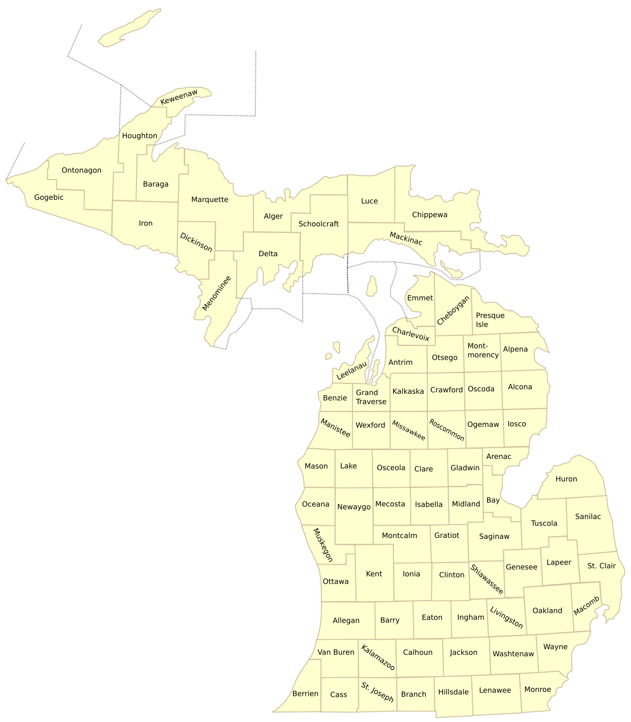
Whether you need an alphabetical list of Michigan counties for research, are verifying official county seats and courthouse addresses, studying county population rankings from the U.S. Census Bureau, or looking for printable cartographic maps, this comprehensive directory provides the complete, authoritative guide to all 83 Michigan county jurisdictions.
📌 Michigan County System: Key Fast Facts
Complete List of Michigan Counties in Alphabetical Order
Below is the complete, verified inventory of all 83 Michigan counties arranged alphabetically from Alcona to Wexford. Click on highlighted county names to access our detailed county map pages, city and township breakdowns, highway guides, and printable vector maps:
| # | County Name | County Seat | Est. Population | Land Area | Total Area | FIPS | Geographic Region |
|---|---|---|---|---|---|---|---|
| 1 | Alcona County | Harrisville | 10,167 | 674 sq mi | 1,791 sq mi | 26001 | Northern Lower |
| 2 | Alger County | Munising | 8,769 | 918 sq mi | 5,049 sq mi | 26003 | Upper Peninsula |
| 3 | Allegan County | Allegan | 120,502 | 825 sq mi | 1,833 sq mi | 26005 | West Michigan |
| 4 | Alpena County | Alpena | 28,907 | 574 sq mi | 1,695 sq mi | 26007 | Northern Lower |
| 5 | Antrim County | Bellaire | 23,431 | 477 sq mi | 602 sq mi | 26009 | Northern Lower |
| 6 | Arenac County | Standish | 15,002 | 367 sq mi | 681 sq mi | 26011 | Mid-Michigan |
| 7 | Baraga County | L’Anse | 8,158 | 904 sq mi | 1,069 sq mi | 26013 | Upper Peninsula |
| 8 | Barry County | Hastings | 62,422 | 553 sq mi | 577 sq mi | 26015 | West Michigan |
| 9 | Bay County | Bay City | 103,856 | 444 sq mi | 631 sq mi | 26017 | Great Lakes Bay |
| 10 | Benzie County | Beulah | 17,970 | 321 sq mi | 860 sq mi | 26019 | Northern Lower |
| 11 | Berrien County | St. Joseph | 154,316 | 568 sq mi | 1,581 sq mi | 26021 | Southwest Michigan |
| 12 | Branch County | Coldwater | 44,862 | 506 sq mi | 520 sq mi | 26023 | Southern Border |
| 13 | Calhoun County | Marshall | 134,310 | 706 sq mi | 718 sq mi | 26025 | Southwest Michigan |
| 14 | Cass County | Cassopolis | 51,589 | 490 sq mi | 508 sq mi | 26027 | Southwest Michigan |
| 15 | Charlevoix County | Charlevoix | 26,054 | 417 sq mi | 1,391 sq mi | 26029 | Northern Lower |
| 16 | Cheboygan County | Cheboygan | 25,579 | 715 sq mi | 885 sq mi | 26031 | Northern Lower |
| 17 | Chippewa County | Sault Ste. Marie | 36,785 | 1,561 sq mi | 2,698 sq mi | 26033 | Upper Peninsula |
| 18 | Clare County | Harrison | 30,856 | 567 sq mi | 575 sq mi | 26035 | Central Michigan |
| 19 | Clinton County | St. Johns | 79,128 | 569 sq mi | 575 sq mi | 26037 | Mid-Michigan |
| 20 | Crawford County | Grayling | 12,988 | 556 sq mi | 563 sq mi | 26039 | Northern Lower |
| 21 | Delta County | Escanaba | 36,903 | 1,171 sq mi | 1,992 sq mi | 26041 | Upper Peninsula |
| 22 | Dickinson County | Iron Mountain | 25,947 | 761 sq mi | 777 sq mi | 26043 | Upper Peninsula (Central Time) |
| 23 | Eaton County | Charlotte | 109,175 | 576 sq mi | 579 sq mi | 26045 | Mid-Michigan |
| 24 | Emmet County | Petoskey | 34,057 | 468 sq mi | 882 sq mi | 26047 | Northern Lower |
| 25 | Genesee County | Flint | 406,211 | 637 sq mi | 649 sq mi | 26049 | Flint / Mid-Michigan |
| 26 | Gladwin County | Gladwin | 25,386 | 502 sq mi | 516 sq mi | 26051 | Central Michigan |
| 27 | Gogebic County | Bessemer | 14,380 | 1,102 sq mi | 1,476 sq mi | 26053 | Upper Peninsula (Central Time) |
| 28 | Grand Traverse County | Traverse City | 95,238 | 465 sq mi | 601 sq mi | 26055 | Northern Lower |
| 29 | Gratiot County | Ithaca | 41,761 | 570 sq mi | 572 sq mi | 26057 | Central Michigan |
| 30 | Hillsdale County | Hillsdale | 45,742 | 598 sq mi | 607 sq mi | 26059 | Southern Border |
| 31 | Houghton County | Houghton | 37,361 | 1,012 sq mi | 1,502 sq mi | 26061 | Upper Peninsula |
| 32 | Huron County | Bad Axe | 31,407 | 836 sq mi | 2,137 sq mi | 26063 | The Thumb |
| 33 | Ingham County | Mason | 284,900 | 556 sq mi | 561 sq mi | 26065 | Capital Region |
| 34 | Ionia County | Ionia | 66,804 | 571 sq mi | 580 sq mi | 26067 | West Michigan |
| 35 | Iosco County | Tawas City | 25,237 | 549 sq mi | 1,891 sq mi | 26069 | Northern Lower |
| 36 | Iron County | Crystal Falls | 11,631 | 1,166 sq mi | 1,211 sq mi | 26071 | Upper Peninsula (Central Time) |
| 37 | Isabella County | Mt. Pleasant | 64,394 | 572 sq mi | 578 sq mi | 26073 | Central Michigan |
| 38 | Jackson County | Jackson | 160,366 | 707 sq mi | 723 sq mi | 26075 | South Central Michigan |
| 39 | Kalamazoo County | Kalamazoo | 261,670 | 561 sq mi | 580 sq mi | 26077 | Southwest Michigan |
| 40 | Kalkaska County | Kalkaska | 17,939 | 560 sq mi | 571 sq mi | 26079 | Northern Lower |
| 41 | Kent County | Grand Rapids | 657,974 | 847 sq mi | 872 sq mi | 26081 | West Michigan Hub |
| 42 | Keweenaw County | Eagle River | 2,172 | 541 sq mi | 5,966 sq mi | 26083 | Upper Peninsula (Copper Country) |
| 43 | Lake County | Baldwin | 12,096 | 568 sq mi | 575 sq mi | 26085 | West Central Michigan |
| 44 | Lapeer County | Lapeer | 88,619 | 654 sq mi | 663 sq mi | 26087 | The Thumb / Metro Fringe |
| 45 | Leelanau County | Suttons Bay | 22,301 | 347 sq mi | 2,532 sq mi | 26089 | Northern Lower |
| 46 | Lenawee County | Adrian | 99,423 | 750 sq mi | 761 sq mi | 26091 | Southern Border |
| 47 | Livingston County | Howell | 194,385 | 565 sq mi | 585 sq mi | 26093 | Metro Detroit Fringe |
| 48 | Luce County | Newberry | 5,339 | 903 sq mi | 1,912 sq mi | 26095 | Upper Peninsula |
| 49 | Mackinac County | St. Ignace | 10,834 | 1,022 sq mi | 2,101 sq mi | 26097 | Upper Peninsula (Straits) |
| 50 | Macomb County | Mount Clemens | 881,217 | 479 sq mi | 570 sq mi | 26099 | Metro Detroit / Lake St. Clair |
| 51 | Manistee County | Manistee | 25,032 | 542 sq mi | 1,281 sq mi | 26101 | Northern Lower |
| 52 | Marquette County | Marquette | 66,017 | 1,808 sq mi | 3,425 sq mi | 26103 | Upper Peninsula Hub |
| 53 | Mason County | Ludington | 29,052 | 495 sq mi | 1,242 sq mi | 26105 | West Michigan Coast |
| 54 | Mecosta County | Big Rapids | 39,714 | 555 sq mi | 567 sq mi | 26107 | Central Michigan |
| 55 | Menominee County | Menominee | 23,502 | 1,044 sq mi | 1,338 sq mi | 26109 | Upper Peninsula (Central Time) |
| 56 | Midland County | Midland | 83,494 | 518 sq mi | 528 sq mi | 26111 | Great Lakes Bay |
| 57 | Missaukee County | Lake City | 15,052 | 565 sq mi | 574 sq mi | 26113 | Northern Lower |
| 58 | Monroe County | Monroe | 155,274 | 551 sq mi | 680 sq mi | 26115 | Lake Erie Shoreline |
| 59 | Montcalm County | Stanton | 66,614 | 707 sq mi | 721 sq mi | 26117 | Central Michigan |
| 60 | Montmorency County | Atlanta | 9,153 | 548 sq mi | 563 sq mi | 26119 | Northern Lower |
| 61 | Muskegon County | Muskegon | 176,511 | 499 sq mi | 1,459 sq mi | 26121 | West Michigan Coast |
| 62 | Newaygo County | White Cloud | 49,978 | 842 sq mi | 861 sq mi | 26123 | West Central Michigan |
| 63 | Oakland County | Pontiac | 1,274,395 | 868 sq mi | 907 sq mi | 26125 | Metro Detroit Hub |
| 64 | Oceana County | Hart | 26,585 | 512 sq mi | 1,307 sq mi | 26127 | West Michigan Coast |
| 65 | Ogemaw County | West Branch | 20,770 | 563 sq mi | 575 sq mi | 26129 | Northern Lower |
| 66 | Ontonagon County | Ontonagon | 5,811 | 1,311 sq mi | 3,741 sq mi | 26131 | Upper Peninsula |
| 67 | Osceola County | Reed City | 22,891 | 566 sq mi | 573 sq mi | 26133 | Central Michigan |
| 68 | Oscoda County | Mio | 8,219 | 565 sq mi | 572 sq mi | 26135 | Northern Lower |
| 69 | Otsego County | Gaylord | 25,091 | 515 sq mi | 526 sq mi | 26137 | Northern Lower |
| 70 | Ottawa County | Grand Haven | 296,200 | 563 sq mi | 1,632 sq mi | 26139 | West Michigan Lakeshore |
| 71 | Presque Isle County | Rogers City | 12,982 | 659 sq mi | 2,573 sq mi | 26141 | Northern Lower |
| 72 | Roscommon County | Roscommon | 23,459 | 520 sq mi | 580 sq mi | 26143 | Northern Lower |
| 73 | Saginaw County | Saginaw | 189,591 | 800 sq mi | 816 sq mi | 26145 | Great Lakes Bay |
| 74 | St. Clair County | Port Huron | 160,383 | 721 sq mi | 837 sq mi | 26147 | Blue Water / The Thumb |
| 75 | St. Joseph County | Centreville | 60,939 | 501 sq mi | 521 sq mi | 26149 | Southern Border |
| 76 | Sanilac County | Sandusky | 40,611 | 963 sq mi | 1,590 sq mi | 26151 | The Thumb |
| 77 | Schoolcraft County | Manistique | 8,047 | 1,178 sq mi | 1,884 sq mi | 26153 | Upper Peninsula |
| 78 | Shiawassee County | Corunna | 68,094 | 531 sq mi | 541 sq mi | 26155 | Mid-Michigan |
| 79 | Tuscola County | Caro | 53,323 | 803 sq mi | 1,125 sq mi | 26157 | The Thumb |
| 80 | Van Buren County | Paw Paw | 75,587 | 607 sq mi | 1,090 sq mi | 26159 | Southwest Michigan Coast |
| 81 | Washtenaw County | Ann Arbor | 372,258 | 706 sq mi | 722 sq mi | 26161 | Southeast Michigan |
| 82 | Wayne County | Detroit | 1,793,561 | 597 sq mi | 672 sq mi | 26163 | Metro Detroit Urban Core |
| 83 | Wexford County | Cadillac | 33,673 | 565 sq mi | 576 sq mi | 26165 | Northern Lower |
The 15 Upper Peninsula Counties & The Central Time Zone
Michigan’s Upper Peninsula (U.P.) accounts for nearly one-third of the state’s total land area, encompassing 15 sprawling, wilderness-rich counties. Connected to the Lower Peninsula by the iconic 5-mile Mackinac Bridge over the Straits of Mackinac, the U.P. features vast state and national forests, the Lake Superior shoreline, copper and iron ranges, and outdoor recreational centers:
- The 15 U.P. Counties: Alger, Baraga, Chippewa, Delta, Dickinson, Gogebic, Houghton, Iron, Keweenaw, Luce, Mackinac, Marquette, Menominee, Ontonagon, and Schoolcraft.
- The Central Time Zone Border Counties: While 79 of Michigan’s 83 counties operate on Eastern Time (ET), four western Upper Peninsula counties border the State of Wisconsin and officially observe Central Time (CT): Gogebic County, Iron County, Dickinson County, and Menominee County.
Michigan Counties by Land Area: Largest & Smallest
When analyzing Michigan counties by surface dimensions, there is a marked contrast between landmass and territorial water boundaries:
Top 10 Largest Counties by Land Area
- Marquette County: 1,808 sq miles (Seat: Marquette)
- Chippewa County: 1,561 sq miles (Seat: Sault Ste. Marie)
- Ontonagon County: 1,311 sq miles (Seat: Ontonagon)
- Schoolcraft County: 1,178 sq miles (Seat: Manistique)
- Delta County: 1,171 sq miles (Seat: Escanaba)
- Iron County: 1,166 sq miles (Seat: Crystal Falls)
- Gogebic County: 1,102 sq miles (Seat: Bessemer)
- Menominee County: 1,044 sq miles (Seat: Menominee)
- Mackinac County: 1,022 sq miles (Seat: St. Ignace)
- Houghton County: 1,012 sq miles (Seat: Houghton)
Top 10 Smallest Counties by Land Area
- Benzie County: 321 sq miles (Seat: Beulah)
- Leelanau County: 347 sq miles (Seat: Suttons Bay)
- Arenac County: 367 sq miles (Seat: Standish)
- Charlevoix County: 417 sq miles (Seat: Charlevoix)
- Bay County: 444 sq miles (Seat: Bay City)
- Grand Traverse County: 465 sq miles (Seat: Traverse City)
- Emmet County: 468 sq miles (Seat: Petoskey)
- Antrim County: 477 sq miles (Seat: Bellaire)
- Macomb County: 479 sq miles (Seat: Mount Clemens)
- Cass County: 490 sq miles (Seat: Cassopolis)
Note on Water Area: If territorial waters extending into Lake Superior, Lake Michigan, and Lake Huron are counted, Keweenaw County is by far Michigan’s largest total county at 5,966 square miles, of which 5,425 square miles (over 90%) consists of Lake Superior waters and Isle Royale National Park.
Michigan Counties Ranked by Population
Michigan’s population distribution is concentrated predominantly in the southern half of the Lower Peninsula, particularly across Metro Detroit, the Grand Rapids metropolitan hub, and the Capital Region:
Top 10 Most Populated Counties
- Wayne County: 1,793,561 residents (Seat: Detroit)
- Oakland County: 1,274,395 residents (Seat: Pontiac)
- Macomb County: 881,217 residents (Seat: Mount Clemens)
- Kent County: 657,974 residents (Seat: Grand Rapids)
- Genesee County: 406,211 residents (Seat: Flint)
- Washtenaw County: 372,258 residents (Seat: Ann Arbor)
- Ottawa County: 296,200 residents (Seat: Grand Haven)
- Ingham County: 284,900 residents (Seat: Mason)
- Kalamazoo County: 261,670 residents (Seat: Kalamazoo)
- Livingston County: 194,385 residents (Seat: Howell)
Top 10 Least Populated Counties
- Keweenaw County: 2,172 residents (Seat: Eagle River)
- Luce County: 5,339 residents (Seat: Newberry)
- Ontonagon County: 5,811 residents (Seat: Ontonagon)
- Schoolcraft County: 8,047 residents (Seat: Manistique)
- Baraga County: 8,158 residents (Seat: L’Anse)
- Oscoda County: 8,219 residents (Seat: Mio)
- Alger County: 8,769 residents (Seat: Munising)
- Montmorency County: 9,153 residents (Seat: Atlanta)
- Alcona County: 10,167 residents (Seat: Harrisville)
- Mackinac County: 10,834 residents (Seat: St. Ignace)
Michigan’s Historic “Cabinet Counties”
A unique cartographic chapter in Michigan history occurred during the administration of President Andrew Jackson in 1829. To honor the sitting presidential cabinet, the Michigan Territorial Legislature created eight neighboring counties in the southern tier named after Jackson and his cabinet secretaries:
- Jackson County: Named directly for President Andrew Jackson.
- Calhoun County: Named for Vice President John C. Calhoun.
- Berrien County: Named for Attorney General John M. Berrien.
- Ingham County: Named for Treasury Secretary Samuel D. Ingham.
- Eaton County: Named for Secretary of War John Eaton.
- Branch County: Named for Navy Secretary John Branch.
- Barry County: Named for Postmaster General William T. Barry.
- Van Buren County: Named for Secretary of State (and later 8th U.S. President) Martin Van Buren.
📥 Download Official Printable Michigan County Maps
Download free vector cartographic PDFs and high-resolution outline maps optimized for desktop printing, school assessments, and commercial logistics:
Frequently Asked Questions About Michigan Counties
How many counties are in Michigan?
There are exactly 83 counties in Michigan. Fifteen counties are located in the Upper Peninsula, and 68 counties comprise the Lower Peninsula.
What is the largest county in Michigan by size?
Marquette County in the Upper Peninsula is the largest Michigan county by land area at 1,808 square miles. Keweenaw County is the largest by total area (5,966 square miles) when including Great Lakes territorial waters.
What is the smallest county in Michigan?
Benzie County in the Northern Lower Peninsula is the smallest county in Michigan by land area at only 321 square miles. Keweenaw County has the smallest population with approximately 2,172 residents.
What is the most populated county in Michigan?
Wayne County, which includes the City of Detroit and its surrounding suburbs, is the most populated county in Michigan with approximately 1.79 million residents.
What are the 15 counties in Michigan’s Upper Peninsula?
The 15 Upper Peninsula counties are Alger, Baraga, Chippewa, Delta, Dickinson, Gogebic, Houghton, Iron, Keweenaw, Luce, Mackinac, Marquette, Menominee, Ontonagon, and Schoolcraft.
Which Michigan counties are in the Central Time Zone?
Four Michigan counties in the western Upper Peninsula border Wisconsin and operate on Central Time (CT): Gogebic, Iron, Dickinson, and Menominee. The other 79 Michigan counties operate on Eastern Time (ET).
What was the first county formed in Michigan?
Wayne County was the first county established in Michigan, organized in 1796 under the Northwest Territory prior to Michigan achieving statehood in 1837.