
Positioned in the geographic center of Michigan’s Lower Peninsula within the bustling Tri-Cities region, Midland County is renowned for its harmonious balance of world-class chemical innovation, architectural significance, pristine river valleys, and thriving parklands. Whether you are navigating between the corporate headquarters of Dow Chemical, planning a family trip to Dow Gardens, researching property boundaries in rural townships, or studying regional watersheds, this comprehensive Midland County Map provides the exact geographic details you need. Explore our interactive resources, township profiles, and free downloadable map.
Interactive Midland County Map Michigan
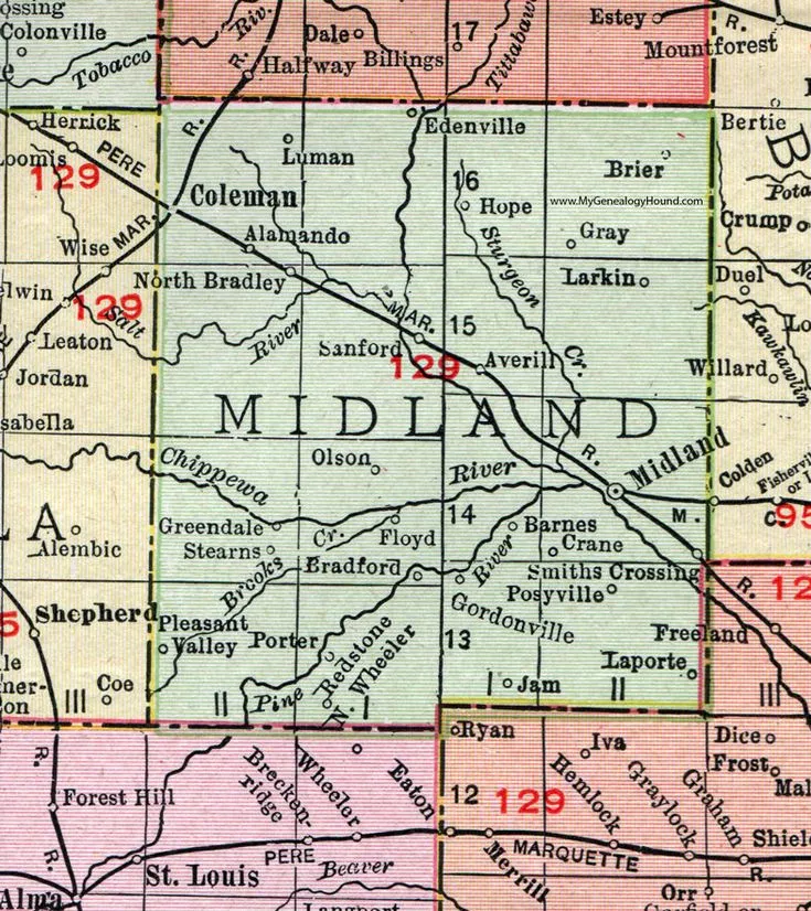
When exploring the geographic layout of Midland County, key navigational landmarks include:
- Principal Municipalities: The City of Midland (County Seat), City of Coleman, and Village of Sanford.
- Arterial Highway Corridors: US Highway 10 (US-10) freeway connecting to Bay City and Clare, M-20 connecting Mount Pleasant to Midland, and M-30 running north into Gladwin County.
- Scenic River Systems: The Tittabawassee River, Chippewa River, Pine River, and Salt River.
- Premier Cultural & Recreational Destinations: Dow Gardens (featuring the nation’s longest Canopy Walk), Chippewa Nature Center, Midland Center for the Arts, and the Tridge (world-famous three-way footbridge).
Need a wider view of the Great Lakes State? Explore our master Interactive Michigan County Map covering all 83 Michigan counties.
Midland County Quick Facts & Geographic Data
Created in 1831 and officially organized in 1855, Midland County serves as an anchor of the Saginaw Valley and Tri-Cities metropolitan area (alongside Bay and Saginaw counties).
| Geographic Metric | Data / Details |
|---|---|
| County Seat | Midland, MI |
| Region | Central Michigan / Tri-Cities |
| Established | March 2, 1831 (Organized 1855) |
| Total Area | 528 sq miles (1,367 km²) |
| Land Area | 516 sq miles (97.7%) |
| Water Area | 12 sq miles (2.3%) |
| Population (Census Est.) | ~83,494 residents |
| Population Density | 161.8 people per sq mile |
| FIPS Code | 26-111 |
| Major Highways | US-10, M-20, M-30 |
| Bordering Counties | Gladwin (North), Bay (East), Saginaw (Southeast), Gratiot (Southwest), Isabella (West), Clare (Northwest) |
Midland County Township Map & Communities Guide
Midland County is structured into 16 civil townships. Understanding the distinctions between suburban charter townships and rural agricultural zones is vital for planning, property ownership, and road navigation:
Suburban Growth Corridors
- Larkin Charter Township: Bordering the north side of Midland city, Larkin is one of the county’s fastest-growing residential communities, known for premier suburban subdivisions and top-rated schools.
- Homer Township: Located southwest of Midland city, balancing quiet rural living, subdivisions along the Chippewa River, and convenient highway access.
- Midland Charter Township: Encircles portions of the city of Midland, hosting critical industrial infrastructure and established residential neighborhoods.
- Ingersoll Township: Bordering Saginaw County to the southeast, known for rich agricultural farmlands and scenic river valley acreage.
Lakes, Rivers & Northern Townships
- Jerome & Edenville Townships: Home to the village of Sanford and Sanford Lake, these northern communities are centered around boating, fishing, and community waterfront revitalization.
- Lincoln & Hope Townships: Featuring rolling rural terrain, family farms, and inland lakes popular for seasonal camping and fishing.
- Geneva, Greendale, Jasper, Lee, Mills, Mount Haley, Porter & Warren Townships: These tranquil townships comprise the agricultural and timberland heartland of western and central Midland County, offering extensive acreage, hunting land, and outdoor privacy.
Why You Need a Dedicated Midland County Map
A precision Midland County Michigan Map serves multiple practical uses:
- Navigating River Corridors & Trails: Locate kayak launches along the Chippewa and Tittabawassee rivers, and access trailheads for the 30-mile paved Pere Marquette Rail-Trail.
- Real Estate & Zoning Research: Determine township tax jurisdictions, municipal water access, and school district lines (Midland Public Schools, Bullock Creek, Meridian, and Coleman).
- Commercial Logistics: Map commercial trucking routes between the US-10 freeway and industrial complexes across the Great Lakes Bay Region.
Frequently Asked Questions (FAQ) – Midland County Map
What is the county seat of Midland County, Michigan?
The county seat of Midland County is the City of Midland. Founded at the confluence of the Tittabawassee and Chippewa rivers, it serves as the administrative, cultural, and economic hub of the county.
What is \”The Tridge\” in Midland, Michigan?
The Tridge is a famous three-way wooden footbridge located in downtown Midland that spans the confluence of the Chippewa and Tittabawassee rivers. It connects Chippewa Trail, St. Charles Park, and the Farmers Market area.
What major highways run through Midland County?
The primary freeway is US-10, providing four-lane expressway transit east to I-75/Bay City and west toward Clare. State highway M-20 connects Midland directly to Mount Pleasant and Central Michigan University, while M-30 provides a direct north-south connection into Gladwin County.
Explore Other Michigan County Maps
Explore detailed maps and municipal guides for neighboring regions across Michigan:
- Genesee County Map – Flint metro hub, highway corridors & township boundaries.
- Washtenaw County Map – Ann Arbor, Ypsilanti & University of Michigan district.
- Alcona County Map – Lake Huron shoreline, Huron National Forest & Harrisville.
- Keweenaw County Map – Lake Superior shoreline, Brockway Mountain & Copper Harbor.