
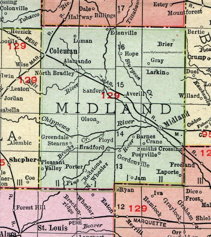
Located in the heart of Michigan’s Lower Peninsula, Midland County is known for its balanced mix of urban development, industrial innovation, and natural beauty. Whether you’re planning a trip, researching local geography, or studying county lines, a detailed Midland County map helps you understand the area’s layout more clearly.
For a full overview of every region in the state, visit our Michigan County Map — an interactive guide covering all 83 counties.
Where is Midland County in Michigan?
Midland County is centrally positioned, bordered by Gladwin, Bay, Saginaw, Isabella, and Clare Counties. The county seat, Midland City, is a vibrant community known for the Dow Gardens, Chippewa Nature Center, and the Pine and Tittabawassee Rivers that flow through its landscape.
| Feature | Details |
|---|---|
| County Seat | Midland |
| Region | Central Michigan |
| Founded | 1831 |
| Area | 528 sq mi |
| Major Highways | US-10, M-20, M-30 |
| Nearby Counties | Gladwin, Clare, Isabella, Saginaw, Bay |
| Population (2020) | ~83,000 |
| ZIP Codes | 48623–48686 range |
What the Midland County Map Shows
A Midland County map displays key roadways, townships, rivers, and parks — offering a complete picture for travelers and residents alike. Its road system connects smaller townships with neighboring economic centers like Saginaw and Bay City.
Important townships featured on the Midland County township map include:
- Homer Township – a blend of rural scenery and community living.
- Larkin Township – suburban developments near the Midland city core.
- Lincoln Township – home to farmlands and small lakes.
- Jerome Township – popular for the Sanford Lake recreation area.
- Geneva Township – quiet countryside with outdoor trails and nature parks.
Key Landmarks & Natural Areas
- Dow Gardens – a 110-acre botanical garden and one of Midland’s most visited sites.
- Chippewa Nature Center – 1,200 acres of trails and riverfront ecosystems.
- Sanford Lake – ideal for boating, fishing, and summer recreation.
- Barstow Woods Park – perfect for family picnics and short hiking loops.
Why Use a Midland County Michigan Map?
A Midland County Michigan map helps you:
- Navigate between townships, cities, and landmarks.
- Understand property lines, local zoning, and natural areas.
- Plan travel routes and outdoor trips.
- Study Michigan’s county-level geography for education or research.
If you’re exploring other regions of the state, don’t miss our detailed Alcona County Map MI guide. It highlights Alcona County’s townships, scenic roads, and key attractions along Michigan’s northeastern shoreline.