
Washtenaw County is the vibrant heart of Southeastern Michigan, a dynamic blend of world-class education, cutting-edge innovation, and rich cultural scenes. Navigating from the bustling streets of Ann Arbor to the historic charm of Ypsilanti requires a precise tool. This Washtenaw County Map is more than a directory; it’s your essential key to understanding the neighborhoods, townships, and arteries that power this iconic region. Whether you’re a student mapping your way to class, a family planning a move, or a visitor exploring, our interactive and printable maps will guide you.
Interactive Washtenaw County Map Michigan
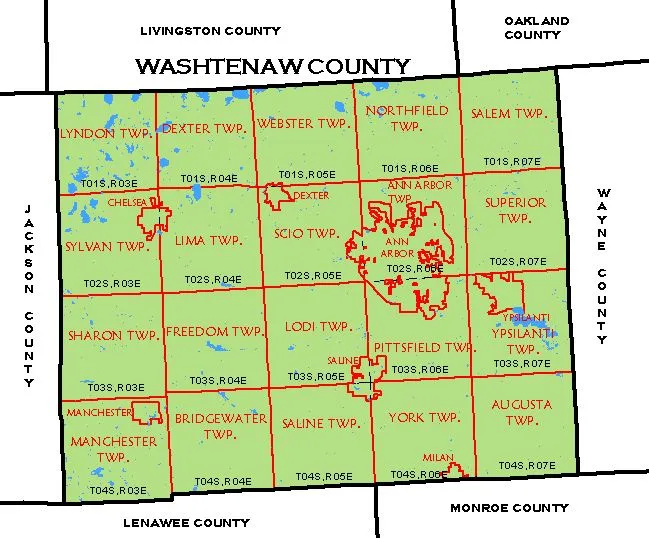
- Cities & Villages (Ann Arbor, Ypsilanti, Chelsea, Saline, Dexter)
- Township Boundaries (Ann Arbor Twp, Ypsilanti Twp, Scio Twp, Pittsfield Twp)
- Major Highways & Roads (I-94, US-23, M-14, M-17)
- Points of Interest (University of Michigan Campus, Eastern Michigan University, Huron River Parks, Hospitals, Cultural Districts)
Getting a broader view of the region? See how Washtenaw connects to its neighbors on our complete Michigan County Map.
Where is Washtenaw County, Michigan?
Washtenaw County is strategically positioned in Southeastern Michigan, directly southwest of Wayne County (Detroit). It serves as a critical corridor between Detroit and points west, making it a central hub for commerce, education, and culture.
| Feature | Details |
|---|---|
| County Seat | Ann Arbor |
| Region | Southeastern Michigan |
| Founded | 1826 |
| Total Area | 722 sq mi |
| Population (2023 Est.) | ~372,000 |
| Major Highways | I-94, US-23, M-14 |
| Bordering Counties | Wayne, Oakland, Livingston, Ingham, Jackson, Lenawee, Monroe |
| Key Institutions | University of Michigan, Eastern Michigan University |
Washtenaw County Township Map & Key Communities
The county’s character shifts dramatically from urban centers to scenic rural landscapes. Our detailed Washtenaw County Township Map clarifies these vital boundaries.
- City of Ann Arbor: The cosmopolitan core, home to the University of Michigan, top-tier hospitals, and a thriving downtown.
- City of Ypsilanti: A historic community with Eastern Michigan University and a vibrant, artistic identity.
- Ann Arbor Township: Borders the city, featuring upscale residential areas and protected green spaces.
- Scio Township: A rapidly growing area with a mix of residential subdivisions and commercial development.
- Pittsfield Township: A diverse township with significant retail, light industry, and residential communities.
- Saline & Chelsea: Charming, autonomous small cities known for their excellent school systems and strong community feel.
Why Use a Detailed Washtenaw County Map?
A precise Washtenaw County MI Map is indispensable for:
- Real Estate & Relocation: Identify precise school districts (e.g., Ann Arbor Public vs. Saline vs. Dexter), neighborhood boundaries, and proximity to employment hubs.
- University Life: Navigate the vast UMich and EMU campuses, find student housing, and locate essential services.
- Business & Commuting: Plan optimal routes around the complex I-94/US-23 interchange and understand the commercial landscape of different townships.
- Recreation & Culture: Locate parks along the Huron River, find your way to museums, theaters, and unique shopping districts.
Printable Washtenaw County Map (Free PDF Download)
For offline planning, we offer a high-resolution, printable Washtenaw County Map in PDF format. This is perfect for:
- Prospective students and parents touring the area.
- Real estate agents and home buyers analyzing locations.
- Community planners and educators.
Conclusion: Navigate Michigan’s Cultural Capital with Confidence
From the academic energy of Ann Arbor to the authentic spirit of Ypsilanti, Washtenaw County is a region of endless discovery. We’ve built this Washtenaw County Map resource to be the most authoritative, user-friendly, and comprehensive guide available. Your exploration of this dynamic corner of Michigan starts with the right map.