
Tucked at the very tip of Michigan’s Upper Peninsula, Keweenaw County isn’t just a location; it’s an experience of raw, unspoiled nature. A detailed Keweenaw County Map is less a navigational tool and more a key to unlocking America’s frontier history and breathtaking Lake Superior scenery. Whether you’re planning a rugged backpacking trip, tracing copper mining heritage, or seeking the solitude of Isle Royale, our interactive and printable maps are your first step into this remote and magnificent corner of Michigan.
Interactive Keweenaw County Map Michigan
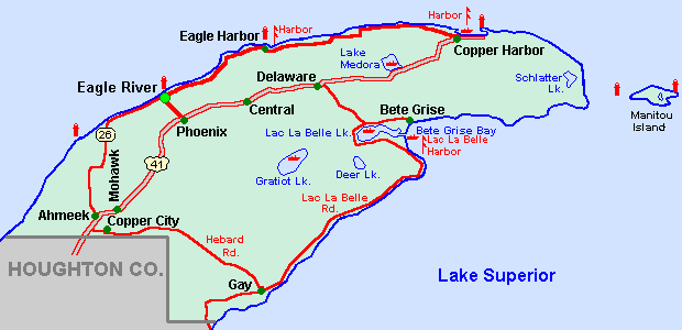
- Towns & Hamlets (Copper Harbor, Eagle Harbor, Delaware)
- Natural Features (Lake Superior shoreline, rivers, Brockway Mountain)
- Points of Interest (Lighthouses: Ft. Wilkins, Eagle Harbor; Ghost Towns: Central, Mandan; Hiking Trails: Estivant Pines, Brockway Mountain Drive)
- Transportation & Access (Ferry routes to Isle Royale, US-41 terminus)
Planning a broader Upper Peninsula adventure? Our master Interactive Michigan County Map provides context for how Keweenaw connects to the rest of the state.
Where is Keweenaw County, Michigan?
Keweenaw County is the northernmost part of Michigan, a rugged peninsula jutting into Lake Superior. It’s famously remote, accessible via a drive through Houghton County, and feels a world away from the rest of the Midwest.
| Feature | Details |
|---|---|
| County Seat | Eagle River (One of the smallest in the U.S.) |
| Largest Settlement | Copper Harbor (Gateway to Isle Royale) |
| Region | Upper Peninsula / Copper Country |
| Founded | 1861 |
| Total Area | 5,966 sq mi (Largest in Michigan by total area) |
| Water Area | ~91% (Explains the vast area with low population) |
| Population (2020 Est.) | ~2,100 (Least populous in Michigan) |
| Known For | Copper mining history, Isle Royale National Park, extreme snowfall |
Why is a Keweenaw County Map Essential?
A standard state map won’t cut it here. A dedicated Keweenaw County MI Map is crucial because:
- Navigating Remote Terrain: Cell service is unreliable. A downloadable, offline map is a safety necessity for exploring forest roads and finding remote trailheads.
- Exploring “Ghost Towns”: Locate the remnants of the copper boom, like Central Mine and Mandan, which are scattered off the main highways.
- Planning Your Isle Royale Trip: Visualize ferry departure points from Copper Harbor and understand the logistics of accessing the national park.
- Understanding the Geography: The county is over 90% water. A proper map helps you comprehend the sheer scale of the Lake Superior coastline and inland waterways you’re exploring.
Printable Keweenaw County Map (Free PDF Download)
For your adventure into the wild, we offer a high-resolution, printable Keweenaw County Map in PDF format. This is not a luxury; it’s essential gear for:
- Hikers and backpackers venturing into the trails.
- History buffs exploring off-the-grid mining sites.
- Road trippers driving the scenic Brockway Mountain Drive.
Conclusion: Your Journey to the End of the Road Begins Here
Keweenaw County offers a rare glimpse into a wilder America. It’s a place of profound quiet, deep history, and staggering natural beauty. We’ve built this Keweenaw County Map Michigan resource to be the most trusted and practical guide for the intrepid travelers drawn to this unique destination. Your Upper Peninsula adventure starts with the right map.